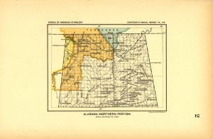
The Northern Alabama Land Cessions map was initially drawn up for a series found in the 18th Annual Report of the Bureau of American Ethnology. Specifically, it was created to reference the compilation by Charles C. Royce for the Indian Land Cessions in the United States. Since the map was drawn up in 1896 it only references those land cessions occurring before that year.
The Northern Alabama Land Cessions map was drawn by A. Hoen & Company, Lithographers from Baltimore.
Map by Cession #
The map references 4 specific cessions as defined by Treaties, Acts and Agreements with Indian Tribes across Alabama. The treaties referenced by those areas can be found below:
- Cession 64
- Treaty of January 7, 1806
The Cherokees cede to the United States all claim to all that tract of country lying to the northward of the river Tennessee and westward of a line to be run from the upper part of the Chickasaw Old Fields, at the upper point of an island called Chickasaw Island, on said river, to the most easterly head waters of that branch of Tennessee River called Duck River. The boundaries of this cession overlap the Chickasaw cession of November 14, 1805, and in turn are overlapped by the boundaries of the Chickasaw cession of September 20, 1816. For explanation and elucidation of this cession, see Cherokee treaty of September 11, 1807.
- Treaty of January 7, 1806
- Cession 80
- Treaty of September 20, 1816
The Chickasaw nation cede to the United States (with the exception of such reservations as shall hereafter be specified) all right or title to lands on the North side of Tennessee river. The Chickasaws also relinquish all claim to territory on the South side of Tennessee river and East of a line commencing at the month of Caney Creek and running up the same to its source; thence a due South course to the Ridge Path, commonly called Gaines’ Road; along said road southwestwardly to a point on Tombigby River, called Cotton Gin Port, and down the West bank of the Tombigby to the Choctaw boundary. This cession overlaps the Cherokee cession of September 11, 1816.
- Treaty of September 20, 1816
- Cession 81
- Treaty of September 20, 1816
One tract of land for the use of Col. George Colbert and his heirs, described as follows: Beginning on the North bank of Tennessee river at a point that, running North 4 miles, will include a big spring about halfway between his ferry and the mouth of Cypress Creek, it being a spring that a large cow path crosses its branch near where a cypress tree is cut down; thence westwardly to a point 4 miles from the Tennessee River, and standing due North of a point on the North bank of the river 3 [4] miles below his ferry on the Tennessee River, and up the meanders of said river to the beginning. Confirmed to George Colbert and his heirs by treaty of October 19, 1818. Subsequently deeded to the United States May 15, 1819.
- Treaty of September 20, 1816
- Cession 178
- Treaty of October 20, 1832
The Chickasaw nation, finding themselves oppressed in their present situation by being made subject to the laws of the States in which they reside, which laws they can not understand, rather than submit to this evil, prefer to seek a home in the West where they may live and be governed by their own laws. Believing they can procure for themselves a home in a country suited to their wants and condition, provided they had the means to pay for the same, they have determined to sell their country and hunt a new home. Therefore, for the consideration hereinafter expressed, the Chickasaw nation cede to the U. S. all the land which they own on the East side of the Mississippi River, including all the country where they at present live and occupy. It is agreed that the boundary line between the Choctaw and Chickasaw country, as formerly owned by them East of the Mississippi, shall be definitely ascertained and established. This cession overlaps the Cherokee cession of September 14, 1816.
- Treaty of October 20, 1832
Land Cessions by Tribe
The following information references the current tribal names for each specific land cession.
/home/accessgenealogy/public_html/wp-content/uploads/2016/10/52-Northern-Alabama-Land-Cessions-Map-2016-10-06.csv is an Invalid Spreadsheet file.
Map References
The following pages on our site (and others) references the Alabama Land Cessions Map. We do not include the treaties already listed above.
- Alabama Land Cessions by Native American Tribes
The Native American tribes of Alabama who ceded lands to the United States Government. Included in this list, were the tribes names at the time of the cession, and present day tribal name.
