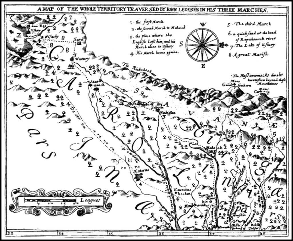
The Shenandoah Valley, first explored by Johann Lederer and his associates in 1670, holds a rich history shaped by early exploration, settlement, and conflict. Following Lederer’s journey, which reached as far west as present-day Strasburg, VA, the region saw further exploration by Colonel Cadwallader Jones in 1673 and George Ritter in 1705. In 1719, Thomas Fairfax inherited the Northern Neck proprietary estate, managing it as a feudal manor and significantly influencing the area’s development. Germanic and other European settlers, recruited by Fairfax’s agents, began shaping the valley’s landscape with intensive farming practices. Native American presence in the valley persisted until the mid-18th century, with peaceful coexistence giving way to displacement during the French and Indian War. The departure of Native Americans by 1754 marked a pivotal shift in the valley’s demographic and cultural composition.

The first recorded exploration of the Shenandoah Valley was by German immigrant, Johann Lederer, and several associates in 1670. They went as far west as present day Strasburg, VA, then turned around. His journey came on the heels of a decade of ethnic cleansing by the Rickohockens. Colonel Cadwallader Jones explored the central part of the valley in 1673. Colonial records do not document any more expeditions until 1705, when George Ritter, from Bern, Switzerland, led a party into the heart of the Shenandoah Valley, then decide to settle east of the valley.
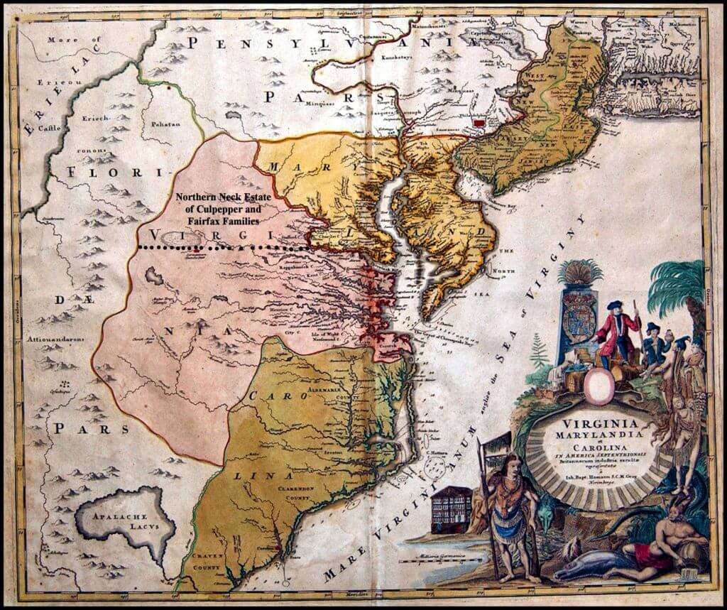
In 1719, Thomas Fairfax, 6th Lord of Cameron, inherited the 5,282,000 acre Northern Neck proprietary estate in what is now Northern Virginia. Unlike most portions of the British North American colonies, it was operated as feudal manor in which tenants paid land rents, rather than owning their farms fee simple. However, some tracts were sold outright to purchasers from prominent families in England, and later in Fairfax’s life, to anyone with the money. Between 1719 and 1732, Robert “King” Carter became extremely wealthy working as Lord Fairfax’s agent. Carter focused sales and rentals on the east side of the Blue Ridge Mountains. There were few settlers in the heart of the Shenandoah Valley until after 1732. That was when Lord Fairfax moved to Virginia and began developing his plantation. He sent agents to Europe to recruit tenants, who were skilled yeoman farmers.
The Shenandoah Valley’s unique man-made landscape is a result of its mid-and-late 18th century settlement patterns. The Germanic settlers were accustomed to intensive farming of tracts ranging between 50 and 60 acres in size. The North Fork of the Shenandoah Valley was almost exclusively settled by Protestant immigrants from the German Palatinate, the Netherlands, Switzerland, Moravia and Denmark. The portion of the valley north of where the two forks join was settled at the same time by Germans, Ulster Irish and Quakers from Pennsylvania. The western half of Rockingham County, in the southern end of the valley was settled by Mennonites from Pennsylvania. The first Mennonites arrived around 1730, but there were not substantial numbers of Mennonites until the 1820s.
Native Americans continued to live on lands officially owned by Fairfax until 1753. Early Shenandoah County resident and historian, Samuel Kercheval, wrote in his book, A History of the Valley of Virginia, that European and Native American settlers lived side by side. The Indians did not pay land rent to Lord Fairfax. Relations were peaceful between Europeans and Native Americans until 1754. Those Natives not involved with the hostilities between Great Britain and France left the region, when war began.

Apparently, none of the Natives in the heart of the valley were indigenous. Immediately prior to the arrival of British settlers, the northern tip of the Shenandoah County had been occupied by a branch of the Huron (Wyandot) Indians. The Wyandot cultivated high quality tobacco, which was traded throughout New England, southern Canada and Great Lakes region. According to tradition, the Huron were driven out of the Valley in the late 1600s by the Iroquois Confederacy. By the time that the settlers arrived in the valley, the northern tip was occupied by Tuscarora refugees from North Carolina.
Some Shawnee villages were located in the vicinity of present day Winchester and Front Royal, VA. The principal town of this band of Shawnee was located at Shawnee Springs, immediately west of Winchester, VA. In 1753 emissaries traveled to the Shenandoah Shawnee and invited them to move west. All Shawnee soon left the valley and relocated in eastern Ohio.
There were Native American farmsteads and extended family hamlets scattered about the Shenandoah Valley until 1754. There is very little information about their ethnicity. Apparently, they migrated from various parts of eastern Virginia, or were remnant tribes. It is believed that they moved south during the French & Indian War and joined the Cherokees.
Midwestern tribes continued to attack the Shenandoah Valley farmsteads until around 1766. Attacks on frontiersmen in present day West Virginia continued to beyond the end of the Revolution. After aroun1756 there is no mention in official records of any Native American living in the Shenandoah Valley.
