Dr. O. G. Libby, of University, N. D., and Dr. A. B. Stout, of the New York Botanical Garden, who ten years ago examined this old Cheyenne village site on the Sheyenne River, most kindly consent that I should announce the results of their work there; and Dr. Melvin R. Gilmore, Curator of the Historical Society of North Dakota, where the maps and notes on this village site are deposited, agrees that the material should be published. This generous permission enables me to add to this paper the maps made in 1908 by Dr. Libby and Dr. Stout, as well as their recorded notes, which furnish some further details as to the village as they found it. The matter is of interest to students of the Plains tribes, who will be grateful to these gentlemen for the opportunity to learn the results of their inquiry.
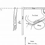
The north face of village (fig. 33) is on slope of about 45° to old river bed some 40 feet below. To east a gentle slope extends. A shallow and gently sloping ravine separates village from a round topped broad knoll by road evidently the burial ground.

To the south a gently sloping level area extends. To the west a trail can be traced about 20 rods. It extends down slope to edge of marsh land where a spring is now located.
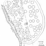
No large, well defined refuse heaps are to be found. No traces of refuse heaps are to be found in village or along ditch. On the slopes of the bank facing old river channel are evidences of refuse especially near rings Nos. 4-7 and between 14 and 18. At latter place -a path leads down to a small refuse pile. A path not only leads directly down but paths come diagonally down slope as shown.
Located on a flat area of land overlooking old river channel and also overlooking surrounding lands to east and south. See larger map (fig. 33) for general topography. Rings inside plowed field — to south of fence indicated — have been plowed over for past 8 years — hence all that could be done was to locate tepee sites. — The centers and ditch showed plainly.

Hut rings in pasture are nearly all quite distinct and outlines are easily deter-mined.
Ditch is from 16 to 28 or 30 feet wide and at opening to west is 2| feet deep. In no place in pasture is ditch less than if feet deep.
The “cache” pits are shallow depressions. They vary in depth from a few inches to a foot or a foot and a half. Most of them are from three to eight feet across.
