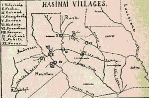
For determining the location of these tribes our chief materials are the Journal of Joutel (1687), the Relación of Francisco de Jesus Maria Casañas (1691), De Leon’s diary of the expedition of 1690, Terán’s for that of 1691-2, those of Ramon and Espinosa for the expedition of 1716, Pena’s for that of Aguayo (1721), Rivera’s for his visita of 1727, Solis’s for that made by him in 1767-8, and Mezières accounts of his tours among the Indians in 1772, 1778, and 1779. Two only of these are in print, while two of them have not before been used. 1 Besides these and numerous supplementing documentary sources, there are:
- The early surveys showing the Camino Real, or Old San Antonio Road, whose windings in eastern Texas were determined mainly by the location of the principal Indian villages where the Spaniards had settlements,
- Certain unmistakable topographical features, such as the principal rivers and the Neche Indian mounds, and
- Geographical names that have come down to us from the period of Spanish occupation.
It will be interesting, before studying the location of each one of the tribes separately, to read the general description of the group given by Jesus Maria in 1691. Speaking of the Great Xinesi, he said, “To him are subject all of these nine tribes: The Nabadacho, which, for another name, is called Yneci. Within this tribe are founded the mission of Nuestro Padre San Francisco and the one which I have founded in Your Excellency’s name, that of El Santíssimo Nombre de Maria. The second tribe is that of the Necha. It is separated from the former by the Rio del Arcangel San Miguel [the Neches]. Both are between north and east. 2 At one side of these two, looking south, between south and east, is the tribe of the Nechaui, and half a league from the last, another, called the Nacono. Toward the north, where the above-mentioned Necha tribe ends, is the tribe called Nacachau. Between this tribe and another called Nazadachotzi, which is toward the east, in the direction of the house of the Great Xinesi, which is about half way between these two tribes, 3 comes another, which begins at the house of the Great Xinesi, between north and east, and which is called Cachaé. At the end of this tribe, looking toward the north, is another tribe called Nabiti, and east of this a tribe called the Nasayaha. These nine tribes embrace an extent of about thirty-five leagues and are all subject to this Great Xinesi.” 4 This description will be convenient for reference as we proceed.
It may be noted here that the average league of the old Spanish diaries of expeditions into Texas was about two miles. This should be kept in mind when reading the data hereafter presented.
Citations:
- Of the diaries of De León and Espinosa I cite only the manuscripts in the Archivo General y Pãblico, Mexico. These, I believe, are not otherwise available, and have not before been used except by Mr. R. C. Clark, who has recently had access to my transcripts. Of Jesus Maria’s Relaci6n I follow an autograph manuscript, which, however, appears to be a copy instead of the original. Of the diaries of Terán and Ramón I have had access to the originals, and of the Mezières manuscripts either to the originals or to certified official copies. My copy of the Rivera diary is from the edition printed in 1736. For the Peña and Soils diaries I have had to depend upon the copies in the Memorias. On comparing Memorias transcripts, in general, with the originals I have found that they are very corrupt and that numerous mistakes have resulted from their use. But in cases where there are no essential differences, I cite the Memorias copies, because they are more generally accessible; otherwise I cite the originals.[
]
- Meaning north and east of the point where he was writing, near San Pedro Creek, Houston County, as will appear below.[
]
- My text (see note 3, p. 256) may be correct here. It reads “q esta, Como almediodia y enel Medio de las dos N’aciones.” It is possible that the copyist first wrote almediodia by mistake for enel Medio de and then wrote the latter correctly, but neglected to erase the words written by mistake. Other data seem to bear out this supposition.[
]
- Relación of Francisco de Jesus Maria Casañas (1691), 107-108.[
]
