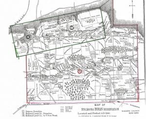
The Tuscarora Reservation, in Niagara County, New York, is formed from 3 adjoining tracts successively acquired, as indicated on the map. Their early antecedents as kinsmen of the Iroquois, their wanderings westward to the Mississippi, and their final lodgment at the head waters of the rivers Neuse and Tar, in North Carolina, are too much enveloped in tradition to be formulated as history, but courageous, self-supporting, and independent, after long residence upon lands owned by them in that colony, they first came into collision with white people, then with other tribes of that section, until finally, overpowered by numbers, they surrendered their lands upon the Neuse and Tar rivers, and by a treaty with the state of North Carolina removed to the banks of the Roanoke, The white people gave them no peace in their new home, and from 1715 to 1722 they removed to New York, near Oneida lake, and were admitted by their kinsmen of the Five Nations into the Iroquois Confederacy, thereafter known as the Six Nations.
In 1780 they removed to the mountain which o overlooks Lake Ontario, near the present town of Lewiston. This land site had been formerly occupied by other red men, remains of an ancient fort still remaining, also several mounds bearing signs of great antiquity. The Senecas donated 1 mile square as a resting home, and the Holland Land Company affirmed the grant and conveyed to them an additional 2 miles eastward, covering the entire north face of the mountain, upon which old fortifications rested. In 1804 the Tuscarora’s sold their lands in North Carolina, and with $13,722 of the proceeds purchased of the Holland Land Company, with the sanction of the United States, an additional tract of 4,329 acres, thus securing the title in fee simple to a total area of 6,249 acres, which they still retain.
A road from Lewiston touches the northwest corner of the reservation at a distance of a little over 2.5 miles and passes eastward at the foot of the mountain, while a fork, turning sharply to the right, ascends the mountain its Whole length, leads to Pekin, and bears the appropriate name, “The Mountain road.” A second road from Lewiston climbs the mountain at the station of the Rome, Watertown and Ogdensburg railroad; connects with a road from Suspension bridge, 5 miles distant, and enters the reservation at the Mountpleasant estate. This, nearly parallel with the mountain road, is known as the Mount Hope road. Still another road from Suspension bridge courses along the south line of the reservation and leads to the town of Sanborn.
Nearly the entire land not reserved for timber has been put to use. Five crossroads connect the two main roads running east and west. The whole reservation is under fence, the chiefs enforcing a rule that every landowner shall maintain a fence at least 4 feet high. Only one prostrate rod of fence, and that washed away by a sudden freshet, was seen during a visit to every house on the reservation. Reference is made to the map for a specific description of the land as divided among the people. With the exception of a few farms on the Holland donation tract, where wells must be dug, pure spring water for domestic and agricultural purposes is abundant. The migration of young men and the death of energetic heads of families have left widows who are land rich but purse poor. They have not the means to hire labor and are thus compelled to lease their farms to white men and live on the rental income. Even the most successful farmers are unable to find Indian laborers sufficient for the demand, and they also rent portions at a cash rental or on shares. Following the example of the white people, who have utilized the rich valley north of the mountain for fruit, the Tuscarora’s have developed line orchards of peach and apple trees to the extent of 269 acres. There is not a ragged, untrimmed orchard on the reservation. Two non-bearing years, almost three, have not worn out the patience of these farmers. The orchard spaces have been well utilized, and the whiter wheat, already well advanced in November, gave promise of good returns.
The Tuscarora Indians
The Tuscarora Indians were admitted to the Iroquois League on the ground of a common generic origin, retaining their own hereditary chiefs, but without enlarging the original framework of the confederacy. They had authority to be represented and enjoy nominal equality in the councils. They are styled “sons “, and in turn use the term “fathers” in their official relations with the league. No authority exists by which they can be disturbed by the league in the management of their own affairs. The prevalent opinion to the contrary is an error. In the Revolutionary War and in the War of 1812, they were faithful to the white people, and in the War of the Rebellion they furnished a reasonable contingent of volunteers to the Union cause.
Vacancies among the chiefs are filled by the women of the clans entitled to the appointment. Here, as among the Onondaga and Tonawanda bands, the ruling chiefs arrogate and occasionally exercise the power of displacing chiefs by formal deposition. It is a stretch of prerogative to exercise this power except for a cause that would require a substantial impeachment, but there is no method of redress. The laws are few; the income is small; the people as a rule are orderly, peaceable, and accommodating;” so that society moves along evenly, but sluggishly, with rare infringement upon personal rights or disturbances of public peace. The crossroads are poor because the nation is poor, and public funds are inadequate to pay for their repair. Fences, however, are well Maintained under regulations well enforced by’ he governing chiefs. The distinction of sachem chiefs is retained by the governing chiefs as a title, but no practical difference in authority is recognized.
The government during the 1890 census year was constituted as follows:
Thomas Williams (Beaver), president, sachem, ago 36; Luther W. Jack (Wolf), clerk, sachem, 31; Daniel Printup (Beaver), treasurer, warrior, 50; Phillip T. Johnson (Sand Turtle), Warrior chief, 30; Simon A. Thompson (Wolf), warrior chief, 55; William J. Johnson (Turtle), sachem, 32; Grant. Mountpleasant (Turtle), warrior chief; 22; Marcus Pater (Beaver), sachem, 42; Nicholas Cusick (Beaver), warrior chief, 30; Isaac Patterson (Sand Piper), Snipe, sachem, 54; George Williams (Sand Piper), Snipe, Warrior chief, 24; James Bembleton (Bear), warrior chief, 60; Jefferson Chew (Beaver), warrior chief, 22; James Bembleton, sr. (Eel), warrior chief, 62.
Tuscarora Indian Reservation Occupants in 1890
We have carefully copied the names listed on the map in hopes it will provide a better record but also help you in your search for ancestors.
Section 1-2 – Green
Asa Thompson Estate
Emeline Garlow
John Garlow
Alex Garlow
W. J. Johnson
William J. Johnson
William Mount Pleasant Estate
Widow S. Bembleton
Susan Patterson Estate
Sampson Chew
W. J. Johnson
P. T. Johnson
Vacant
Rachel Printup
Phil. T. Johnson
National Farm
C. Jack
Helen Bennett
Isaac Smith’s Widow
Presbyterian Church and Cemetery
National Barn
C. Jacobs
Old Mission
F. Dean
Widow S. Cusick
Widow J. Cusick
Simeon Bembleton
Capt. C. C. Cusick, US Army
Elias Johnson
Thompson Estate
Luther W. Jack
Elias Johnson
Luther W. Jack
Edward Anderson
Wilson Cusick
Nicholas Cusick
Josiah Williams
Catharine Jack
Ely Patterson
George Rackett
William Williams
Thomas Williams
Helen Jones
Levi Peters
Jas. William Mountpleasant Estate
Daniel Williams
Titus Patterson
J. Hill
Temperance Hall
Jeremiah Peter
Section 3 – Red
Farms at top right of map
Elizabeth Jack
Thomas Williams
Levi Peters
Elizabeth Johnson
Marcus Peter
Heirs of I. Smith
Rachel Smith
William Johnson
Peter Cusick
Section 3 (left to right)
John Mountpleasant Estate
Asa Thompson Estate
J. Mountpleasant Estate
Widow J. Mountpleasant
Juno Rackett
Mt P Estate
J. Rackett
Ed. Anderson
Mt P Estate
Asa Thompson Estate
R. Printup
Heirs of S. J. Jack
Rachel Mountpleasant
Dan Printup
Charlotte Mountpleasant
Heirs of Silas Isaac
Dennis Bembleton
Isaac Garlow
J. Mountpleasant
David Hewitt
Rachel Miller’s Estate
S. Fish
Vacant
M. A. Smith
A. Thompson Estate
Grant Mountpleasant Estate
Dennis Bembleton
C. Mitchall
Enoch Chew Estate
Jack Anderson
Silas Chew
School House
Matilda John
Mary A. Smith
John Bembleton
Frank Mountpleasant
Wm. Garlow
Eliza Green
S. Jacobs
Nancy Cusick
Sarah Fish
Calinda Patterson
Amos Smith
George Green
Edward Anderson
Elias Johnson
Wilson Cusick
James Bembleton
Frank Mountpleasant
National Woods (50 Acres)
Isaac N. Jack
Lucy Mountpleasant
Rachel Printup
Jas. Bembleton
Elizabeth Johnson
Public Domain (640 acres woods)
Joseph Thompson
Sarah A. Thompson
Alex Garlow
Hiram Green
Frank Mountpleasant
Lucy Cusick
Jacob Green
Eliza Bembleton
Elias Johnson
Isaac N. Jack
J Patterson
Jer & Jas Peter
Old Mission School
Abigail Peck
Council House
W. J. Patterson
Eleanor Garlow
Alpheus Hewit
Elias Bissell
Wilkins Cusick
Alex Garlow
Isaac Johnson
Isaac Patterson
A. Williams
S. Green
Baptist Church
H. Garlow
Grant Mountpleasant
Ely Johnson
H. Garsfort
Noah Henry
H.D. Patterson
Store
L. Printup
Eliza Chew
Eliza Miller
W. H. Patterson
J. Bisell
Mary Printup
Eliza Chew
Chris Went
Lucy Williams
James Johnson Estate
Charles Printup
Dan Printup
Marcus Peter, occupied by Wm. Bunker
John Mayorn
National Woods or Commons
N. Henry
Silas Hewitt
Moses Printup
Anna Cusick
S. Printup
S. Thompson
Eliza Miller
Widow Geo. Bembleton
Natl. Thompson
Sarah Bembleton
Mary Thompson
Jas. Bembleton
Elias Smith
S. Chew
Mrs. M. Johnson
Osias Chew
D. Hewitt
Daniel Printup
Chas. Seneca
Peach Orchard
Nations Picnic Grounds
Saml. A. Thompson
Mary Printup
Maria Jacobs
Eleazur Gralow
Amos Printup
Harley Chew
Discover more from Access Genealogy
Subscribe to get the latest posts sent to your email.

