
Tuscarora Reservation Map and Occupants, 1890
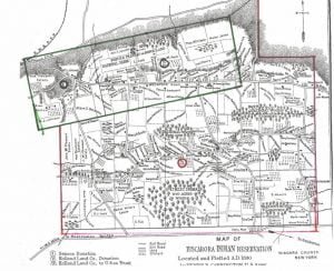
Tuscarora Reservation Map, 1890

The Tuscarora Reservation, established in 1890 in Niagara County, New York, was formed from three tracts acquired over time. The Tuscaroras, originally part of the Iroquois Confederacy, migrated from North Carolina to New York, facing numerous challenges along the way. They cultivated their land, developed extensive orchards, and maintained communal governance. Despite their rich ancestral lands, economic struggles led many to lease farmland to whites. The reservation’s structure and inhabitants are documented, alongside the political leadership of the Tuscarora Nation during that period.
Washington Indian Reservations

This post details the Indian reservations in Washington State, including the tribes associated with each reservation, land size, and the legislative acts or treaties that established them. Notable reservations include Chehalis, Columbia, and Yakima, among others, each with unique historical contexts and varying acreage. The information emphasizes significant treaties such as the Treaty of Medicine Creek and the Treaty of Walla Walla, showcasing the complex history of land allotment and tribal rights in Washington.

Wisconsin Indian Reservations

This post details the Indian reservations in Wisconsin, including the respective tribes, land area, and the legal documents that established each reservation. Notable reservations include Lac Court Oreille with 20,096 acres, Lac du Flambeau at 26,153 acres, and Menominee encompassing 231,680 acres, among others. Each entry outlines the treaties and acts involved, particularly the Treaty of September 30, 1854, which played a significant role in the establishment of these lands for their respective tribes.

South Dakota Indian Reservations

The post details various South Dakota Indian reservations, including their corresponding tribes, acreage, and the legislative actions that established them. Key reservations mentioned are Crow Creek and Old Winnebago, Lake Traverse, Cheyenne River, Lower Brulé, Pine Ridge, Rosebud, and Yankton, each linked to specific Sioux tribes. The post includes significant historical dates, treaties, and proclamations that shaped the current status of these lands, highlighting the ongoing process of land allotment and the complexities of Native American land rights in South Dakota.

Oklahoma Indian Reservations

The post provides a comprehensive list of Oklahoma Indian reservations, detailing the tribes associated with each reservation, the acreage allocated, and the historical treaties and agreements that established them. Notable reservations include the Cherokee (877,229 acres), Chickasaw (1,690,964 acres), and Choctaw (3,505,766 acres), among others. Each reservation’s establishment involved various treaties and executive orders, with many lands now in the process of allotment or having been opened to settlement. The complexities of these legal frameworks reflect the historical interactions between the U.S. government and Native American tribes.

Oregon Indian Reservations

The post provides an overview of Oregon Indian reservations, detailing the tribes associated with each, the acreage designated for them, and the legal frameworks that established these lands. Notable reservations include Grande Ronde, Klamath, Siletz, Umatilla, and Warm Springs, each formed through various treaties and executive orders from the mid-19th century. These reservations reflect the historical complexities of land allocation and the diverse tribal groups of Oregon, alongside their respective legal foundations in federal legislation.

Indian Reservation History

The establishment of Indian reservations in the United States arose from land cessions by Native tribes to the government, beginning in 1786. The goal was to confine Indigenous populations due to expanding white settlement, facilitating government control and promoting agriculture among tribes. Reservations were created through treaties, executive orders, and congressional acts, with changing methods over time. This policy transformed Indigenous lifestyles and ownership structures, culminating in the allotment acts and the eventual creation of Oklahoma as a state, integrating various tribes into the U.S. governance framework.

North Dakota Indian Reservations

The post details various Indian reservations in North Dakota, outlining the tribes associated with each, land acreage, and the legal frameworks establishing them. Key reservations include Devils Lake, home to the Assiniboin and Sioux tribes, with 92,144 acres established by treaties from 1867 and 1904. Fort Berthold encompasses 884,780 acres for the Arikara, Hidatsa, and Mandan, while Standing Rock, covering 1,847,812 acres for multiple Sioux tribes, was established through treaties and executive orders from 1868 onwards. Lastly, the Turtle Mountain reservation for the Pembina Chippewa was established through executive orders in the 1880s.

Nebraska Indian Reservations

The post details the Indian reservations in Nebraska, listing the tribes associated with each reservation, the acreage allocated, and the legal documents that established them. Notably, the Niobrara Reservation is for the Santee Sioux and was established through multiple acts and treaties, covering approximately 32,875.75 acres. The Omaha Reservation covers 12,421 acres, while the Ponca, Sioux, and Winnebago reservations also have documented treaties, totaling various extents of land allocated to the respective tribes. The establishment of these reservations reflects a complex legal history.

New Mexico Indian Reservations

The post presents an overview of New Mexico’s Indian reservations, detailing the tribes associated with each, the acreage of the lands, and their establishment through various acts and executive orders. Key reservations include the Jicarilla Apache, spanning 286,400 acres; the Mescalero Apache, covering 474,240 acres; and several Pueblo reservations, such as Acoma and Laguna, with areas ranging from 17,510 to 215,040 acres. Many reservations were confirmed by U.S. patents and established under old Spanish grants and congressional acts.

New York Indian Reservations

This post details the various Indian reservations in New York, specifying the tribes associated with each, the size of the land in acres, and the historical acts and treaties that established them. Notable reservations include Allegany, Cattaraugus, Oil Springs, Oneida, St. Regis, Tonawanda, and Tuscarora, with sizes ranging from 350 to 30,469 acres. These lands were designated through treaties primarily in the late 18th and 19th centuries, reflecting the complex history of Native American land rights in New York.

Idaho Indian Reservations

The post details Idaho’s Indian reservations, including the Coeur d’Alene, Fort Hall, Lapwai, and Lemhi. Each reservation is associated with specific tribes, the total acres of land, and the legal instruments that established them, such as treaties and executive orders. For instance, the Coeur d’Alene reservation, home to the Coeur d’Oreille, Kutenai, and Pend d’Oreille tribes, comprises 404,480 acres, while Fort Hall is designated for the Bannock and Shoshoni tribes, spanning 447,940 acres.

American Indian Reservations

The post details various Indian reservations in Colorado, Iowa, Michigan, Nevada, North Carolina, Utah, and Wyoming, highlighting the tribes associated with each reservation, the acreage, and the legal acts, treaties, and executive orders used for their establishment. For instance, the Ute reservation in Colorado encompasses 483,750 acres, while the Qualla Boundary in North Carolina totals 63,211 acres. Each entry reveals the complex history of land allocation and indigenous rights through a series of legal and governmental decisions.

Kansas Indian Reservations

The post outlines various Indian reservations in Kansas, detailing the tribes associated with each, the acreage designated, and the treaties and acts enabling their establishment. For example, the Chippewa and Munsee reservation was established by a 1859 treaty, allotting over 4,195 acres; the Iowa reservation was created through treaties in 1854 and 1861, encompassing nearly 11,769 acres. Other reservations mentioned include those for the Kickapoo, Potawatomi, and Sauk and Fox tribes, each with their respective acreages and governing treaties.

Minnesota Indian Reservations

The post outlines Minnesota Indian reservations, detailing the tribes associated with each, land acreage, and the legal frameworks that established them. Key reservations include Bois Fort, Deer Creek, Fond du Lac, Grand Portage, Leech Lake, Mdewakanton, Mille Lac, Red Lake, Vermillion Lake, White Earth, and White Oak Point. Established through various treaties, acts, and executive orders, these reservations have different acreage allotments for tribal members and land reserved for public settlement, reflecting the historical interactions between Indigenous peoples and the U.S. government.

Montana Indian Reservations

Montana Indian Reservations

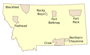
In 1906, Montana Indian Reservations included the Blackfeet, Crow, Fort Belknap, Fort Peck, Jocko, and Northern Cheyenne, each with distinct tribal affiliations and acreage. The Blackfeet Reservation was established via multiple treaties, covering 959,644 acres. The Crow Reservation, at 1,844,182 acres, stemmed from the 1868 treaty. Fort Belknap and Fort Peck Reservations encompassed 497,600 and 1,766,000 acres, respectively, while Jocko had 1,128,182 acres, and Northern Cheyenne covered 489,500 acres, reflecting complex treaty histories and administrative actions.

Arizona Indian Reservations

This post outlines various Indian reservations in Arizona, detailing the tribes assigned to each, the acreage, and the legal means through which they were established. Examples include Camp McDowell, designated for the Yavapai tribe, covering 24,971 acres, and the extensive Navahob reservation, home to the Navaho tribe, encompassing over 9 million acres. Established through executive orders and acts, these reservations reflect the legal and administrative history of tribal land allocation in Arizona.

California Indian Reservations

The post details various California Indian reservations, including the tribes associated with each, the land acreage, and the legislative measures that established them. For example, the Digger Reservation consists of 330 acres and was established in 1893, while the Hupa Valley Reservation covers 99,051 acres, created through a series of acts and executive orders from 1864 to 1891. Other reservations mentioned include Mission (187,958 acres), Round Valley (32,282 acres), Tule River (48,551 acres), and Yuma (45,889 acres), with similar establishment histories.

Chronology of Plains Tribes Culture

The post outlines the cultural history of the Plains Indians, dividing it into prehistoric (pre-Columbian) and historic periods. With limited written records, reliance is placed on observations and archaeological findings. Key cultural characteristics include their nomadic lifestyle, dependence on buffalo, and later adaptation to horse culture introduced around 1540. The post traces significant changes from the horse culture era through the establishment of reservations, culminating in the gradual Americanization and cultural diminishment of the Plains tribes by the late 19th century.

Indian Reservations 1908

In 1908, the Office of Indian Affairs compiled a schedule detailing each Federal Indian Reservation across the United States. The document identified the specific tribes residing in each location, the agency or school associated with the reservation, and the areas that remained unallotted or specially reserved. It also recorded the acreage of reservations by state, highlighting significant land holdings such as Oklahoma’s 9,705,453 acres and Arizona’s 17,025,609 acres, reflecting the diverse landscape of Native American territories during this period.