John Mitchell’s Map

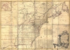
1755 Mitchell Map

The Mitchell Map remained the most detailed map of North America available in the later eighteenth century. Various impressions (and also French copies) were directly used to help establish the boundaries of the new United States of America by diplomats at the Treaty of Paris (1783) that ended the American Revolutionary War. The map’s inaccuracies subsequently led to a number of border disputes, such as in Maine. Its supposition that the Mississippi extended north to the 50th parallel (into British territory) resulted in the treaty using it as a landmark for a geographically impossible definition of the border in that … Read more

1930 Ponca Census Extraction

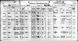
Ponca Census Image

An extraction of the 1930 Indian Census for the Ponca tribe of the Ponca Reservation in South Dakota. In 1930 there were 398 members that fell under the jurisdiction of the Yankton Agency. Most of them still resided within the Ponca Reservation, but some had moved elsewhere and are so indicated within the actual census images. This extraction provides their given names, surnames, sometimes the maiden name, age, and sex of each tribal member.

Probable Mixed-Blood Heads of Household, 1834

Dr. Samuel James Wells’ “Choctaw Mixed Bloods and the Advent of Removal” includes three extensive appendices documenting individuals of mixed ancestry within the Choctaw Nation during the removal era. Appendix C, the focus of this analysis, includes mixed-blood Choctaws Heads of Household in 1834 as taken from the Register of Choctaw Indians: Feb. 24, 1834-May 13, 1834.

Choctaw Mixed-Bloods, 1831-33

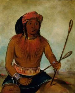
Tul-lock-chísh-ko, Choctaw Ball Player. George Catlin, 1834

Dr. Samuel James Wells’ “Choctaw Mixed Bloods and the Advent of Removal” includes three extensive appendices documenting individuals of mixed ancestry within the Choctaw Nation during the removal era. Appendix B, the focus of this analysis, includes mixed-blood Choctaws from a variety of source documents for the years of 1831-1833.

Micmac Customs And Traditions

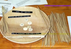
Waltes Bowl and Sticks

My information about the customs and traditions of the Micmac Indians of Nova Scotia has been derived almost entirely from Abram and Newell Glode, the first a man of seventy-three years, the latter somewhat younger and of exceptionally pure blood for a time when none are wholly so. These two Indians have justly achieved a reputation among their tribe for intelligence and knowledge of their native lore. During the many days I have spent with them at Digby and elsewhere I have invariably found them as eager and interested in being questioned as I was in catechizing them. However, in … Read more

The Mi’kmaq Language

Within Algonquian, the Eastern languages are generally considered to constitute a genetic subgroup . Goddard provides a good overview of the languages in this branch. The precise number of distinct languages spoken at contact and their interrelationships are difficult to establish with certainty for several reasons. Many have disappeared. Attestation of some is limited to short word-lists, some showing internal dialect variation. Languages of many groups mentioned in early accounts were never documented at all. There was also continued contact among groups. Early authors differ in their appraisals of mutual intelligibility; some emphasize similarities, others differences. The northernmost and most … Read more

1832 Creek Census – Hitchetee Town

By a treaty of March 24, 1832, the Creek Indians ceded to the United States all of their land east of the Mississippi River. Heads of families were entitled to tracts of land, which, if possible, were to include their improvements. In 1833 Benjamin S. Parsons and Thomas J. Abbott prepared a census of Creek Indian heads of families, which gave their names and the number of males, females, and slaves in each family. The entries were arranged by town and numbered; these numbers were used for identification in later records. This is the 1832 Creek census for the town of Hitchetee.

1832 Creek Census – Hillabee Town

By a treaty of March 24, 1832, the Creek Indians ceded to the United States all of their land east of the Mississippi River. Heads of families were entitled to tracts of land, which, if possible, were to include their improvements. In 1833 Benjamin S. Parsons and Thomas J. Abbott prepared a census of Creek Indian heads of families, which gave their names and the number of males, females, and slaves in each family. The entries were arranged by town and numbered; these numbers were used for identification in later records. This is the 1832 Creek census for the town of Hillabee.

1832 Creek Census – Hihaje Town

By a treaty of March 24, 1832, the Creek Indians ceded to the United States all of their land east of the Mississippi River. Heads of families were entitled to tracts of land, which, if possible, were to include their improvements. In 1833 Benjamin S. Parsons and Thomas J. Abbott prepared a census of Creek Indian heads of families, which gave their names and the number of males, females, and slaves in each family. The entries were arranged by town and numbered; these numbers were used for identification in later records. This is the 1832 Creek census for the town of Hihaje.

1832 Creek Census – High Log Town

By a treaty of March 24, 1832, the Creek Indians ceded to the United States all of their land east of the Mississippi River. Heads of families were entitled to tracts of land, which, if possible, were to include their improvements. In 1833 Benjamin S. Parsons and Thomas J. Abbott prepared a census of Creek Indian heads of families, which gave their names and the number of males, females, and slaves in each family. The entries were arranged by town and numbered; these numbers were used for identification in later records. This is the 1832 Creek census for the town of High Log.

1832 Creek Census – Hickory Ground Town

By a treaty of March 24, 1832, the Creek Indians ceded to the United States all of their land east of the Mississippi River. Heads of families were entitled to tracts of land, which, if possible, were to include their improvements. In 1833 Benjamin S. Parsons and Thomas J. Abbott prepared a census of Creek Indian heads of families, which gave their names and the number of males, females, and slaves in each family. The entries were arranged by town and numbered; these numbers were used for identification in later records. This is the 1832 Creek census for the town of Hickory Ground.

1832 Creek Census – Hatchet Creek Town

By a treaty of March 24, 1832, the Creek Indians ceded to the United States all of their land east of the Mississippi River. Heads of families were entitled to tracts of land, which, if possible, were to include their improvements. In 1833 Benjamin S. Parsons and Thomas J. Abbott prepared a census of Creek Indian heads of families, which gave their names and the number of males, females, and slaves in each family. The entries were arranged by town and numbered; these numbers were used for identification in later records. This is the 1832 Creek census for the town of Hatchet Creek.

1832 Creek Census – Hatcheechubba Towns

By a treaty of March 24, 1832, the Creek Indians ceded to the United States all of their land east of the Mississippi River. Heads of families were entitled to tracts of land, which, if possible, were to include their improvements. In 1833 Benjamin S. Parsons and Thomas J. Abbott prepared a census of Creek Indian heads of families, which gave their names and the number of males, females, and slaves in each family. The entries were arranged by town and numbered; these numbers were used for identification in later records. This is the 1832 Creek census for the town of Hatcheechubba.

1832 Creek Census – Fish Pond Town

By a treaty of March 24, 1832, the Creek Indians ceded to the United States all of their land east of the Mississippi River. Heads of families were entitled to tracts of land, which, if possible, were to include their improvements. In 1833 Benjamin S. Parsons and Thomas J. Abbott prepared a census of Creek Indian heads of families, which gave their names and the number of males, females, and slaves in each family. The entries were arranged by town and numbered; these numbers were used for identification in later records. This is the 1832 Creek census for the town of Fish Pond.

1832 Creek Census – Eufaula Towns

By a treaty of March 24, 1832, the Creek Indians ceded to the United States all of their land east of the Mississippi River. Heads of families were entitled to tracts of land, which, if possible, were to include their improvements. In 1833 Benjamin S. Parsons and Thomas J. Abbott prepared a census of Creek Indian heads of families, which gave their names and the number of males, females, and slaves in each family. The entries were arranged by town and numbered; these numbers were used for identification in later records. This is the 1832 Creek census for the town of Eufaula.

1832 Creek Census – Euchee Town

By a treaty of March 24, 1832, the Creek Indians ceded to the United States all of their land east of the Mississippi River. Heads of families were entitled to tracts of land, which, if possible, were to include their improvements. In 1833 Benjamin S. Parsons and Thomas J. Abbott prepared a census of Creek Indian heads of families, which gave their names and the number of males, females, and slaves in each family. The entries were arranged by town and numbered; these numbers were used for identification in later records. This is the 1832 Creek census for the town of Euche (Euchee).

1832 Creek Census – Emarhe Town

By a treaty of March 24, 1832, the Creek Indians ceded to the United States all of their land east of the Mississippi River. Heads of families were entitled to tracts of land, which, if possible, were to include their improvements. In 1833 Benjamin S. Parsons and Thomas J. Abbott prepared a census of Creek Indian heads of families, which gave their names and the number of males, females, and slaves in each family. The entries were arranged by town and numbered; these numbers were used for identification in later records. This is the 1832 Creek census for the town of Emarhe.

1832 Creek Census – Ekundutske Town

By a treaty of March 24, 1832, the Creek Indians ceded to the United States all of their land east of the Mississippi River. Heads of families were entitled to tracts of land, which, if possible, were to include their improvements. In 1833 Benjamin S. Parsons and Thomas J. Abbott prepared a census of Creek Indian heads of families, which gave their names and the number of males, females, and slaves in each family. The entries were arranged by town and numbered; these numbers were used for identification in later records. This is the 1832 Creek census for the town of Ekundutske.

1832 Creek Census – Cussetaw Town

By a treaty of March 24, 1832, the Creek Indians ceded to the United States all of their land east of the Mississippi River. Heads of families were entitled to tracts of land, which, if possible, were to include their improvements. In 1833 Benjamin S. Parsons and Thomas J. Abbott prepared a census of Creek Indian heads of families, which gave their names and the number of males, females, and slaves in each family. The entries were arranged by town and numbered; these numbers were used for identification in later records. This is the 1832 Creek census for the town of Cussetaw.

1832 Creek Census – Cubihatcha Town

By a treaty of March 24, 1832, the Creek Indians ceded to the United States all of their land east of the Mississippi River. Heads of families were entitled to tracts of land, which, if possible, were to include their improvements. In 1833 Benjamin S. Parsons and Thomas J. Abbott prepared a census of Creek Indian heads of families, which gave their names and the number of males, females, and slaves in each family. The entries were arranged by town and numbered; these numbers were used for identification in later records. This is the 1832 Creek census for the town of Cubihatcha.