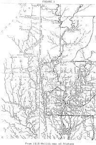
Ever since the dispute between Texas and the United States commenced concerning the title to Greer County, the Choctaw Nation had two of its ablest men in Washington over hauling the old treaties and watching the movements of both disputants. The United States by the Doak’s Stand Treaty in the autumn of 1820 ceded all its territory to the Choctaw’s south of the Canadian River to Red River along the western line of the Indian Territory. The Cherokees had been ceded all north of the Canadian. Texas claimed that the Red River mentioned in the treaty of 1819 between the United States and the King of Spain is the north fork of Red, The United States claimed that the south fork of river is the true Red River. This is where the dispute rose.
Should a future survey be made to determine the questions of boundary lines, and the south fork of Red River be declared the true line, the Choctaw Indians would certainly be the legal owners.

The map used by General Jackson in the treaty at Doak’s Stand was doubtless Melish’s of 1818. That map is doubtless on file in the Department of the Interior in Washington settle the controversy. General Jackson promised to make good the lines shown up the map when the speaking chief at the treaty questioned its accuracy.
The survey, as to how far west the 10th meridian runs has never been made and forty years have passed without the boundary line being known. This is why the Choctaws have never presented their claims to Greer County.
The United States conveyed to the Choctaws, on the 38th of October, 1820, all of their lands west of Arkansas between the Canadian and Red Rivers, that was within the limits of the United States at that time; and on the 19th of February, 1821, the United States conveyed a strip off of the west end, of the same lands conveyed to the Choctaws by the King of Spain, in an exchange for the then Province of Florida. Hence this claim of the Choctaw Nation on what is now known as Greer County. In 1855, 1 the Choctaw Nation ceded to the United States all their lands, then in their possession lying west of the 100, for the consideration of $800,000. Now the Choctaws claim, and justly too, it seems, that they did not make a cession, in 1855, of that portion of the land which the United States sold to the King of Spain, without their consent and for which they have never received a dollar, as it was not in their possession to make a conveyance it then being in the possession of Spain and thus beyond their jurisdiction.
Thus the United States deal with her Indian Wards, whom she had beguiled into her power.
Citations:

