Big Mound City is the only site from the Belle Glade culture on the National Register of Historic Places. 1 It was added in 1973 as an example of a Calusa ceremonial complex, but is now understood to have originally been constructed by the same ethnic group that built the Ortona and Wakate towns – probably ancestors of the Mayaimi. Even though its earthworks are about 1000 to 1500 years older than those of Fort Center, the architecture was extremely similar. Its final phase of occupation was probably by an ethnic group either related to the Tekesta or Mayaimi, but under the political domination of the Calusa.
This large archaeological zone is located on a geographical boundary, where the Everglades portion of the Lake Okeechobee Basin meets the Pinewood Flats. 2 It has been theorized that the location was either a convenient place for ceremonial activities or trading, perhaps both activities. The environs of this ceremonial site were flooded at least six months out of the year. The earthworks would have raised any temples or houses above the floodwaters. This is also an architectural trait of several cultures in the Upper Amazon Basin of Brazil and Peru. The similarity may be evidence of a cultural connection or mere coincidence.

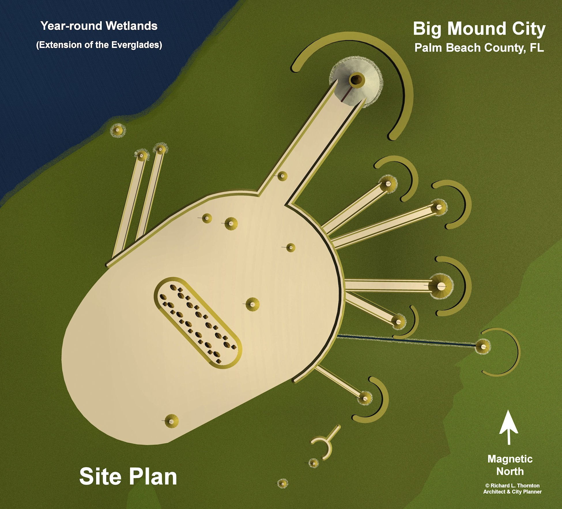
What really makes Big Mound City stand out among large town sites in the Southeastern United States are the paired earth berms that connect conical mounds of various sizes to a central crescent shaped causeway that even today is nine feet high and nine feet wide across the top. The earth berms form radians that seem to have astronomical functions, but to date, have not been defined. What exist today are speculations that have not been confirmed by scientific analysis.
Big Mound City’s occupation has been radiocarbon dated from about 500 BC until about AD 1650. 3 Thus, it was contemporary with the early stages of Fort Center and is older than the Ortona and Wakate sites. It was occupied for centuries after Ortona and Wakate were pretty much abandoned. Currently, archaeologists believe that most of the visible structures in the archaeological zone were completed after Wakate was abandoned. Several of the larger mounds were begun during much earlier periods. However, the linking of the mounds and final construction seems to date from the Late Mississippian Period (1450 AD – 1600s AD.) This may be a misinterpretation of the radiocarbon dates of surface materials due to later repairs, however.

Within this zone are at least 23 mounds, including two or more burial mounds. 4 The intricate geometric arrangements of earthworks were made of yellow and white sand, except for a massive oval platform that contained extensive midden remains. It was probably the location of an elite village.
The large semicircular embankment measures 1,520 feet in diameter. There are five circular mounds within the central enclosure, all measuring around 9 feet in height. Eight conical truncated mounds are connected to the embankment by radial causeways. The largest mound measures 220 feet in diameter at its base and reaches 25 feet high. The walls of the causeway are nine feet high.

The architecture of Big Mound City may have represented practical concerns and cultural influences from elsewhere. Earthen, sand and shell platforms raised temples and elite residences above frequent flooding. Like at Wakate and several other town sites, commoner housing was typically built on timber posts that also raised the sleeping levels above flood waters, poisonous water moccasin snakes, bears, cougars and alligators.
It was botanical research that first brought Big Mound City to the attention of archaeologists. During the 1920s, John Kunkel Small, Curator of the New York Botanic Garden, participated in several expeditions in South Florida in order to collect and document plant specimens. On one trip in 1928, Small photographed Big Mound City. John Kunkel Small’s photographs are the earliest known documentation efforts of the monument.

The Works Progress Administration (WPA) sponsored the initial archaeological studies of Big Mound City. During 1933 and 1934 archaeologist, Gene Sterling, was hired by the WPA to survey and excavate the ruins. 5 While large sections of the site were excavated, very few artifacts were recovered. This would indicate that very few people were living at the site or the site was only occupied for brief periods during the year.
Since the 1930s, archaeologists have periodically debated and speculated the functions of the site. Unlike Wakate, it appears to have been primarily ceremonial in function, although it did contain a substantial permanent population. Recent research by archaeologists, who specialize in astronomical analysis, suggests the radiating earthen berms in the archaeological zone may be aligned to celestial events like solstices, equinoxes or other events like the rise and fall of Venus.
Citations:
- “The Early History of the Corbett Wildlife Management Area.” Friends of the Corbett Wildlife Management Area web site.[
]
- “The Early History of the Corbett Wildlife Management Area.” Friends of the Corbett Wildlife Management Area web site.[
]
- “The Early History of the Corbett Wildlife Management Area.” Friends of the Corbett Wildlife Management Area web site.[
]
- “The Early History of the Corbett Wildlife Management Area.” Friends of the Corbett Wildlife Management Area web site.[
]
- “The Early History of the Corbett Wildlife Management Area.” Friends of the Corbett Wildlife Management Area web site.[
]
