San Juan Pueblo

San Juan lies upon the sand dunes, 20 feet above the left bank of the Rio Granule. From this slight elevation the fields stretching to the north, west, and south show by their different colors that a variety of crops is produced. Compared to Taos, the character of San. Juan is more that of it great garden. Crossing the broad acequia, one leaves the arid sands to enter milk verdure. Trim fences of cedar limbs driven into time ground in close line or-dry brush Fastened upon posts with thongs of leather inclose little holdings of half tin acre or more, … Read more

San Ildefonso Pueblo

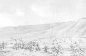
Santa Clara’s neighbor on the south is San Ildefonso. The village lies on the opposite side of the river, 5 miles below, and at the intersection of Pojoaque River, which meets the Rio Grande at right angles from the east. The dwellings are built upon a large, well kept plaza of rectangular shape, and the only plaza in the pueblos having shade trees. From this center the buildings are found variously placed. Close to it on the acequia are several Mexican houses and in the fields at a distance several others. Inquiries developed the fact that years ago these families … Read more

San Felipe Pueblo

Pueblo of San Felipe

At my first visit to San Felipe I was denied entrance to the pueblo, owing to a secret dance which was in progress. The next day, coming on invitation, I found the council of principals already assembled and anxious to make amends for the inhospitable treatment of the day before. We discussed 2 large tracts of land, each available for cultivation, one needing an extension of the acequia and the other a boom in the river, Upon leaving the line of San Domingo, along which every foot was cultivated, one enters a tract of the same sort of land, 2,500 … Read more

San Domingo Pueblo

This pueblo touches Cochiti on the north and San Felipe on the south, where its line runs at an angle of 50 degrees with the river and invades the square northern comers of the latter. Its population of nearly 1,000, is industrious and utilizes all available land. Hundreds of acres, however, are wasted in the riverbed, as they are unwilling to risk crops upon it. An island overgrown by cottonwood trees serves no other purpose than that of a great park for the pueblo. Including this and the river bed, which varies from 1.5 to 1 mile wide, there are … Read more

Sac and Fox Reservation

Report of Special Agent Reuben Sears on the Indians of the Sac and Fox tract or reservation, Sac and Fox agency, Tama County, Iowa. 2.5 miles from the town of Tama, September 1890. Names of Indian tribes or parts of tribes occupying said reservation: (a) Pottawatomie, Sac (Sauk) and Fox of the Mississippi, and Winnebago. The unallotted area of this tract is 1,258 acres, or 2 square miles. The tract has been surveyed and subdivided. It was established by purchase. (See act of Congress approved. March 2, 1867, 14 U. S. Stats, p. 507.) Deeds November 1870, and 1882 and … Read more

Round Valley Reservation

Report of Special Agent I. P. FELL on the Indians of Round Valley reservation, Round Valley agency, Mendocino County, California, January 1891. Names of Indian tribes or parts of tribes occupying said reservation: (a) Koukan, Little Lake, Pitt River, Potter Valley, Redwood, Wailakki, and Yuki. The unallotted area of this reservation is 102,118 acres, or 159.5 square miles. The outboundaries have been surveyed. It was established, altered, or changed by acts of Congress approved April 8, 1801 (13 U. S. State, p. 39), and March 3, 1873 (17 U. S. Stats., p. 631); executive orders March 30, 1870, April 8, … Read more

Reservations of the Six Nations in New York and Pennsylvania, 1723-1890

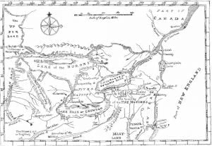
Map of the Country of the Five Nations

The accompanying map was prepared in 1771 under the direction of William Tryon, captain general and governor in chief of the province of New York, and is as nearly suggestive of the then recognized boundary of the Six Nations as any that has had official sanction. In 1851 Lewis H. Morgan, assisted by Ely S. Parker, a Seneca chief; and afterward an efficient staff Officer of General Grant, and the Commissioner of Indian Affairs, prepared a map for a volume entitled League of the Iroquois, which aimed to define the villages, trails, and boundaries of the Five Nations as they … Read more

Report on the Moqui Pueblos of Arizona

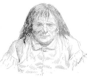
LA-LO-LA-MY, chief of the Oraibi, Moqui Pueblo, Arizona

Report On The Moqui Pueblos Of Arizona By Julian Scott, Special Agent About the residence of Mr. Thomas V. Beam, known as the Tusayan trading post in Keams Canyon, daily collect groups of Indians from various tribes, trading posts, near and far, Navajo, Moqui, and the Oraibi generally, Cojonina, Zuñi and Laguna occasionally, from the plateaus of the north, mesas of the west, and butte country in the south. They come afoot, horseback, on burros, and on mules, bringing with them hides, blankets, baskets, pottery, dried peaches, melons of all kinds, gourds, pumpkins, beans, and corn for barter and trade; … Read more

Report on the 19 Pueblos of New Mexico

The report on the 19 pueblos of New Mexico to the Superintendent of Indian Affairs, June 30, 1864, by United States Indian Agent John Ward, after taking the census, is as follows: Much has been written and a great deal more said about the Pueblo Indians, their origin, enigmas, religion, eta., a great portion of which is mere speculation. The Indians have few memorials, if any, to which they can refer for information, while their traditions, from all that can be learned, are rather limited; besides, they have a very imperfect, knowledge of time, distance, or numbers, which readers them … Read more

Religion of the Six Nation Tribes

With the exception of the Tuscaroras, each of the Six Nations has one or more council houses, in which the people assemble for business or purely Indian ceremonies, religious or social. There is also a council house or town hall on the Mount Hope road of the Tuscarora reservation, but the pagan party has no footing among this people. The council houses, formerly built of logs, are practically in disuse, and frame buildings, about 40 by 80 feet, with fireplace or simple chimney at each end, which allows separate sittings for the sexes, have taken their place. A new building … Read more

Quapaw Reservation in 1890

The Quapaw Indian reservation, located in the northeast corner of the agency, spans 56,685 acres of primarily prairie land. The Quapaw tribe, numbering 154 members, relies on farming and stock raising for their livelihood. While some younger members have adopted modern farming practices, the influence of older members who discourage labor hinders progress. The tribe exhibits fewer signs of assimilation compared to other tribes in the agency. They maintain some traditional practices like the stomp dance and dog dance, and their chiefs are hereditary. The reservation has a boarding school where children receive both academic and practical education.

Pueblo Indians of New Mexico and their Customs

Whatever changes have been made in the daily life, manners, and customs of the Pueblos are shown in the reports of the special agents, but change is the exception with these people. Comparing present conditions with the descriptions for 30, 50, or 300 years ago, one finds the Pueblos in many details now about as then. Marriages are performed in some of the pueblos after courtship and are celebrated by a priest when there is one at hand, but the old ceremonies of the Pueblo faith are also performed, either before or after the marriage, by the priest. H. H. … Read more

Potawatomi Reservation

Pottawatomie and Great Nemaha Agency Report, of Special Agent Reuben Sears on the Indians of the Pottawatomie, Kickapoo, Iowa, and Chippewa and Munsee reservations, Kansas, August and September 1890. Names of Indian tribes or parts of tribes occupying said reservations :(a) Prairie band of Pottawatomi, Kickapoo, [Iowa], Chippewa, and Munsee. The unallotted areas of these reservations are: Pottawatomi, 77,358 acres, or 120.75 square miles; treaties of June 5, 1846, 9 U. S. Stats, p. 853; of November 15, 1861 (12 U. S. Stats, p. 1191); treaty of relinquishment, February 27, 1867 (15 U. S. Stats, p. 531). Kickapoo, 20,273 acres, … Read more

Pojoaque Pueblo

The grant to this pueblo originally contained 13,520 acres. Owing to shrinkage in population the inhabitants have parted with most of their land. At present they have but 25 acres. The pueblo, situated a mile east of the junction of the Pojoaque and Tesuque Rivers, contains 20 persons, They have been in litigation for 4 years with two Mexicans who have settled on the river a mile below the village. This land was not farmed by the Pueblos. The Mexicans therefore appropriated it. The governor says he has wasted much time at count during harvest season over this ease. He … Read more

Picuris Pueblo

The following report was furnished by Mr. Frederick P. Midler, of Taos, New Mexico, February 20, 1891 I have just returned from the pueblo of Picuris. On the journey I and my horse came near freezing, The snow on the mountains and on the trail is 4.5 feet deep. No human being has passed through there this winter, The Indian land under cultivation at Picuris amounts to 555 acres. Out of this every family owns an average of about 15 acres. The sanitary condition can not be called good, as the statistics of the pueblo show that they are every … Read more