The Moqui Tribe in History 1780-1820

Efforts Of Governor Anza To Convert The Moquis 1780 Father Garces reported to Governor Anza his failure at the Moqui pueblos just cited and the governor at once took steps to convert them. H. H. Bancroft (volume xvii pages 265-260) gives the following details translated from the original documents of the efforts of Governor. Anza to convert the Moquis: Back from this campaign [in 1778] Governor Anna gave his attention to the Moquis A failure of crops had reduced that people to such straits that the time was deemed most favorable for their conversion even Christianity being perhaps preferable to … Read more

The Indians in Indian Territory

The following tribes are the Indians residing in Indian Territory in 1890, who were not a part of the five civilized tribes of Indian Territory. The various tribes of Quapaw agency, especially the Modocs, Peorias, and Ottawas, are the remnants of once formidable or large bands or tribes of Indians. The Modocs are from Oregon and northern California. They are from Lutuamian stock, and came from Klamath; agency, Oregon. After the Modoc war in northern California in 1873, the United States in 1875 removed the Modocs from the Lava bed country to their present location in Indian Territory, the lands … Read more

The Eastern Cherokee Nation in 1890

The Cherokee Nation by a treaty made in 1817, ceded to the United States an area of land lying east of the Mississippi river. In exchange for this the United States ceded to that part of the nation then on the. Arkansas. River as much land on that river, acre for acre, as the United. States received from them east of the Mississippi River, and provided that all treaties then in force should continue in full force with all of the Cherokees. This established the two names, eastern and western Cherokees. The eastern band of Cherokees is the portion now … Read more

Tesuque Pueblo

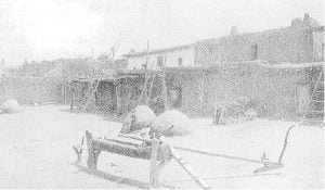
Tesuque Pueblo (Indian Village) near Santa Fe, New Mexico

One approaches Tesuque, situated on the left bank of the river of that name, over a road winding through small orchards fenced by an abatis of cedar boughs driven into the ground, while apple and peach trees tangle their branches overhead. Small patches of wheat and corn lie on either side of the road. The village is built about a quadrangle 240 feet long by 150 feet broad. The houses are mostly of 2 stories. The Catholic Church is small and in a neglected condition. Methods of farming are crude. Both wooden and steel plows are used. Corn is planted … Read more

Taos Pueblo

Feast of San Geronimo

Taos, the most northern of the New Mexican pueblos, lies between the Rio Lucero and Rio Taos. Both streams furnish never failing supplies of water, As a consequence, the crops raised by the Indians are remarkably fine. Corn and wheat are produced in about equal quantities. Fruit and vegetables are rarely seen. The farms range in extent from 9 to 13 acres, though’ some members of the community having large families manage as many as 35 acres, and others variously 30, 24, 18, 16, 10, 8, 6, and 3. These farms yield, when well managed, 30 bushels to the acre. … Read more

St. Regis Tribe

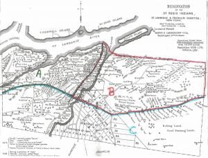
St. Regis Reservation Map, 1890

This article, written in 1890, provides a detailed account of the St. Regis Mohawk people, a group of Indigenous people residing on a reservation that straddles the border of New York and Canada. It examines their history, traditions, and current social, economic, and political realities. The article discusses their unique governance structure, the influence of French culture and Christianity on their way of life, and the challenges posed by their proximity to both the United States and Canada. It also highlights their engagement with the education system and explores the complexities of their identity and naming practices.

Southern Ute Reservation

Report of Special Agent George D. Meston on the Indians of Southern Ute, reservation, Southern Ute agency, Archuleta, La Plata, and Montezuma counties, Colorado, September and October 1890. Names of Indian tribes or parts of tribes occupying said reservation: (a) Kapoti, Muachi, and Wiminuchi Ute. The unallotted area of this reservation is 1,094,400 acres, or 1,710 square miles. It has been partially surveyed and subdivided. It was established, altered, or changed by treaties of October 7, 1883 (13 U. S. Stats., p. 673), and March 2, 1868 (15 U. S. Stats., p. 610) ; act of Congress approved April 29, … Read more

Soldiers of the Eastern Band of Cherokee Indians

The following are the surviving union soldiers of the Eastern Band of Cherokee Indians of North Carolina. The names are correct, but the spelling may differ from that on the muster roll. John Going Welch Thomas Otter James Otter John Brown Owkwataga Mason Ratley Steve Johnson John Taylor John Canott John Igotpa David Patridge James Walkingstick Thomas Canott all of Company D, Third regiment North Carolina mounted infantry; R. B. Smith, company and regiment unknown. The following are the surviving widows of union soldiers: Nancy Brown, widow of Benj. Brown; no children. Ah-nu-yo-hi Walker, widow of John Walker; 1 child … Read more

Six Nations Names, Traditions, And Reminiscences

Indian nomenclature almost invariably has a distinct and suggestive meaning, especially in geographical locations, relations, and peculiarities. Only a few of those, which relate to the accompanying maps are supplied. The location of Bill Hill’s cabin, near the foot of the Onondaga reservation, was called Nan-ta-sa-sis, “going partly round a hill”. Tonawanda creek is named from Ta-na-wun-da, meaning “swift water”. Oil spring, on the Allegany map, was Te-car-nohs, “dropping oil”. The Allegany River was O-hee-yo, “the beautiful river”, and the Geneseo was Gen-nis-he-yo, “beautiful valley”. Buffalo was Do-sho-weh, “splitting the fork”, because near Black Rock (a rocky shore) the waters … Read more

Six Nations Health and Race Admixture

An examination of the annual reports of the United States agents for many years indicates the classes of diseases heretofore most common among the Six Nations. The reluctance of the Indians to employ physicians springs from want of means, want of easy access to physicians, and, in some measure, to the fact that from time immemorial they have relied much upon the use of medicinal roots and herbs in ordinary ailments. The women are practical nurses. This lack of professional treatment and the ignorance of the names of diseases have almost, entirely prevented an accurate specification of the causes of … Read more

Santa Clara Pueblo

Santa Clara is poor. The valley which widens toward San Juan closes again on its approach to Santa Clara. The pueblo occupies a site on the right bank of the river at its junction with the canyon. The stream running from this is apt to dry up before the end of the summer. A system of acequias has been constructed here, and corn was planted this year. But little water was flowing daring my visit in the middle of August, and most of the acequias were dry and dusty, The corn was not mature. A reservoir in the canyon would … Read more

Santa Ana Pueblo

One leaves Zia to follow the Jemez River directly east toward the Sandia range of mountains. The soil from this point rapidly becomes sandy and untillable, and at Santa Ana, 9 miles below, it is entirely unproductive. The inhabitants of this town have long since abandoned it as a place of slimmer abode, and use it only for autumn and winter residence. The town is built upon 2 streets running parallel with the river, and out its bank a single cottonwood tree is the only one seen in a range of many miles. Half a mile back of the town, … Read more

Sandia Pueblo

Like San Felipe, the Sandia Pueblo community holds more land than it can improve. The large Mexican town of Bernalillo presses upon the north side of its tract of 24,187 acres, In 1824 the Indians of the pueblo gave the land on which the town stands, but no patent of this transaction is inexistence. Sales are consummated in the town and await confirmation, Passing 1,200 acres of open land, here and there developing weak traces of alkali, left as a pasture open to the use of the town, cultivation begins half a mile from the pueblo. The acequia, at a … Read more