As mentioned in the sketch of the houses of the Assiniboin, a small party of French accompanied by members of that tribe during the autumn of 1738 went southward from the Assiniboin country to the Mandan towns, where the French remained several weeks. The leader of the expedition, La Verendrye, prepared an account of the journey, this being the earliest record of a visit by Europeans to the Mandans known to exist, although it is easily conceived that French trappers may have been among the tribe earlier in the century.
The expedition arrived among the Mandan November 28, 1738, after a journey of 46 days, but soon pushed forward to a larger village. Fortunately the journal contains references to the ways of life of the Mandan and a brief description of their fortified or protected settlements. At that time the tribe was said to have had six villages, and evidently all were protected by encircling palisades. The village in which the French then rested consisted of 130 lodges, and “all the streets, squares and huts resembled each other.” The French were particularly interested in the manner in which the town was protected, but the account in the journal must exaggerate the strength, or rather the size, of the ditch. The palisade was described as being 15 feet in height, and “At fifteen points doubled are green skins which are put for sheathing when required, fastened only above in the places needed, as in the bastion there are four at. each curtain well flanked. The fort is built on a height in the open prairie with a ditch upwards of fifteen feet deep by fifteen to eighteen feet wide. their fort can only be gained by steps or posts which can be removed when threatened by an enemy. If all their forts are alike, they may be called impregnable to Indians. Both men and women of this nation are very laborious; their huts are large and spacious, separated into several apartments by thick planks; nothing is left lying about; all their baggage is in large bags hung on posts; their beds made like tombs surrounded by skins. Their fort is full of caves, in which are stored such articles as grain, food, fat, dressed robes, bear skins. They are well supplied with these; it is the money of the country. They make wicker work very neatly, flat and in baskets. They make use of earthen pots, which they use like many other nations for cooking their food.” 1 In addition to the six more important villages there appear to have been others, similar but smaller. Referring to these La Verendrye wrote: “We noticed that in the plain there were several small forts, of forty or fifty huts, built like the large ones, but no one was there at the time. They made us understand that they came inside for the summer to work their fields and that there was a large reserve of grain in their cellars. “Evidently these were nearer their cornfields, away from the river banks, and were occupied only parts of each year.
From this all too brief account of the Mandan it is quite evident that when they were first encountered by the French, living in their earth lodges, their villages strongly palisades, their caches filled with corn and other food supplies, buffalo robes and bear skins, they were in their most powerful and prosperous state. But what great changes they were destined to undergo during the next hundred years!
On October 19, 1804, the Lewis and Clark party discovered the first of the ruined villages of the Mandan, evidently standing on the left bank of the Missouri, in the southern part of the present Burleigh County, North Dakota. It proved an interesting day. “In walking along the shore we counted fifty-two herds of buffalo and three of elk, at a single view. Besides these we also observed elk, deer, pelicans, and wolves.” The ruined village had been protected by palisades and, according to the Arikara chief, who accompanied them, had been occupied by the Mandan. These, so they wrote, “are the first ruins which we have seen of that nation in ascending the Missouri.” During the night of October 19 the expedition encamped on the south, i. e., right, bank of the Missouri, evidently about 2 miles below the mouth of Little Heart River, which flows from the westward and joins the Missouri in the present Morton County, North Dakota. The following day they advanced 12 miles up the Missouri.
October 21, 1804, was cold and bleak. Snow and ice covered the ground, and the wind blew strong from the northeast. That day the expedition advanced only 7 miles. They passed the mouth of Big Heart River and the site of Bismarck, the present capital of the State. Two miles above their camp of the night previous, about opposite the mouth of the Big Heart, they reached “the ruins of a second Mandan village, which was in existence at the same time with that just mentioned. It is situated on the north at the foot of a hill in a beautiful and extensive plain, which is now covered with herds of buffaloes; nearly opposite are remains of a third village on the south of the Missouri, and there is another also about two miles further on the north, a little off the river. At the distance of seven miles we encamped on the south, and spent a cold night.” The next day, October 22, they discovered other ruined towns of the Mandan. “In the morning we passed an old Mandan village on the south, near our camp; at four miles another on the same side. At six we reached an island about one mile in length, at the head of which is a Mandan village on the north in ruins, and two miles beyond a bad sandbar. At eight miles are remains of another Mandan village on the south ; and at twelve miles encamped on the south. These villages, which are nine in number, are scattered along each side of the river within a space of twenty miles; almost all that remains of them is the wall which surrounds them, the fallen heaps of earth which covered the houses, and occasionally human skulls and the teeth and bones of men, and different animals, which are scattered on the surface of the ground.” 2 Other deserted villages were passed as they continued ascending the Missouri, to arrive late on the 26th of October, at an old field of the Mandan, about one-half mile below the first of their then occupied villages.
The winter encampment of the expedition, Fort Mandan, was situated on the left bank of the Missouri, about opposite the future Fort Clark, and some 7 or 8 miles below the mouth of Knife River, and consequently several miles from the first Mandan village. Here the expedition remained until April 7, 1805. The lower of the Mandan villages was “Matootonha,” the second and smaller was ” Rooptahee.” The list continues and refers to “the third village which is called Mahawlla, and where the Arwacahwas reside.” “The fourth village where the Minnetaree live, and which is called Metaharta.”A fifth village is mentioned but its name is not given. Referring to these more in detail the narrative tells something of their origin: November 21, 1804, “The villages near which we are established are five in, number, and are the residence of three distinct nations: the Mandans, the Ahnahaway, and the Minnetaree. The history of the Mandans, as we received it from our interpreters and from the chiefs themselves, and as it is attested by existing monuments, illustrates more than that of any other nation the unsteady movements and the tottering fortunes of the American nations. Within the recollection of living witnesses, the Mandans were settled forty years ago in nine villages, the ruins of which we passed about eighty miles below, and situated seven on the west and two on the east side of the Missouri. The two finding themselves wasting away before the small-pox and the Sioux, united into one village, and moved up the river opposite to the Ricaras. The same causes reduced the remaining seven to five villages, till at length they emigrated in a body to the Ricara nation, where they formed themselves into two villages, and joined those of their countrymen who had gone before them. In their new residence they were still insecure, and at length the three villages ascended the Missouri to their present position. The two who had emigrated together still settled in the two villages on the northwest side of the Missouri, while the single village took a position on the southeast side. In this situation they were found by those who visited them in 1796; since which the two villages have united into one. They are now in two villages, one on the southeast of the Missouri, the other on the opposite side, and at the distance of three miles across. The first, in an open plain, contains about forty or fifty lodges, built in the same way as those of the Ricaras: the second, the same number, and both may raise about three hundred and fifty men.
“On the same side of the river, and at the distance of four miles from the lower Mandan village, is another called Mahaha. It is situated in a high plain at the mouth of the Knife river, and is the residence of the Ahnahaway. This nation, whose name indicated that they were ‘people whose village is on a hill,’ formerly resided on the Missouri, about thirty miles below where they now live. The Assiniboin and Sioux forced them to a spot five miles higher, where the greatest part of them were put to death, and the rest emigrated to their present situation, in order to obtain an asylum near the Minnetaree. They are called by the French, Soulier Noir or Shoe Indians; by the Mandans, Wattasoon, and their whole force is about fifty men.
“On the south side of the same Knife river, half a mile above the Mahaha and in the same open plain with it, is a village of the Minnetaree surnamed Metaharta, who are about one hundred and fifty men in number. On the opposite side of Knife river, and one and a half mile, above this village is a second of Minnetaree, who may be considered as the proper Minnetaree nation. It is situated in a beautiful low plain, and contains four hundred and fifty warriors.”
Winter Quarters
In their journal, kept while in winter quarters at Fort Mandan, are to be found many interesting references to the Mandan. To quote several of these will tend to shed light on the ways of life in the native village. On November 22, 1804, the Mandan sold to the members of the expedition “a quantity of corn of a mixed color, which they dug up in ears from the holes made near the front of their lodges, in which it is buried during the winter. “This had probably been gathered only a few weeks before the arrival of the party at the village, then deposited in the caches for future use. December 19 the weather had moderated, and the Indians were seen playing a game on the level space between the lodges of the first and second chiefs, a distance of about 50 yards. The entry for January 13, 1805, contains an interesting note: “We have a continuation of clear weather, and the cold has increased, the mercury having sunk to 34 below 0. Nearly one half of the Mandan nation passed down the river to hunt for several days; in these excursions men, women and children, with their dogs, all leave the village together, and after discovering a spot convenient for the game, fix their tents; all the family bear their part in the labor, and the game is equally divided among the families of the tribe.” And on February 12, it was told how “The horses of the Mandans are so often stolen by the Sioux, Ricara, and Assiniboin, that the invariable rule now is to put the horses every night in the same lodge with the family. In the summer they ramble in the plains in the vicinity of the camp, and feed on the grass, but during cold weather the squaws cut down the cottonwood trees as they are wanted, and the horses feed on the boughs and bark of the tender branches, which are also brought into the lodges at night and placed near them.”
About the year 1797, and consequently a few years before the arrival of the Lewis and Clark expedition at the Mandan villages, John McDonnell, a partner of the North West Company, made brief mention of the Mandan in his journal. He wrote: “These Indians live in settled villages, fortified with palisades, which they seldom ever abandon, and they are the best husbandmen in the whole Northwest. They raise Indian corn or maize, beans, pumpkins, squashes in considerable quantity, not only sufficient to supply their own wants, with the help of the buffalo, but also to sell and give awl y to all strangers that enter their villages.” 3 And in 1804 another representative of the old North West Company referred to the gardens of the Mandans and said in part: “In the spring, as soon as the weather and the state of the ground will permit, the women repair to the fields, when they cut the stalks of the Indian corn of the preceding year and drop new seed into the socket of the remaining roots. A small kind of pumpkins which are very productive they plant with a dibble, and raise the ground into hillocks the same as those about Indian corn. Their kidney beans they plant in the same manner. They cultivate a tall kind of sunflower, the seed of which is reckoned good eating dry and pounded with fat and made into balls of three or four ounces; they are found excellent for long journeys.” 4 And the narrative continued: ” The only implement used among the Mandane for the purpose of agriculture is a hoe made from the shoulder blade of a buffalo and which is ingrafted upon a short crooked handle. With this crooked instrument they work very expeditiously, and soon do all that is required for their supplies.”
As already mentioned, the Lewis and Clark party departed from their winter quarters April 7, 1805, to pursue their journey westward. The next year, on August 14, 1806, when returning, they again arrived at the Mandan villages. They reached Rooptahee, where they were kindly received by the people, but it is interesting to know that during the 16 months which had intervened between the departure and return of the Lewis and Clark party a great change had taken place in the appearance of the native village. As mentioned in the journal, “This village has been rebuilt since our departure, and was now much smaller; a quarrel having arisen among the Indians, in consequence of which a number of families had removed to the opposite side of the river.” Such were the changes ever occurring among the people of the upper Missouri. Old villages were abandoned and new ones built, some to be divided and others united, consequently very few of the ruined sites discovered along the course of the river represent towns which were occupied at the same time.
Although the work just quoted contains much of interest pertaining to the Mandan and neighboring tribes, subsequent writers described the appearance of the villages and separate structures more in detail, and from the narratives of Catlin and Maximilian, supplemented by many sketches, it is possible to visualize the primitive earth-lodge villages with their many peculiar features.

Catlin remained among the Mandan for some weeks during the year 1832 and wrote at that time : “They have two villages only, which are about two miles distant from each other. Their present villages are beautifully located, and judiciously also, for defense against the assaults of their enemies. The site of the lower (or principal) town, in particular is one of the most beautiful and pleasing that can be seen in the world, and even more beautiful than imagination could ever create. In the very midst of an extensive valley (embraced within a thousand graceful swells and parapets or mounds of interminable green, changing to blue, as they vanish in distance) is built the city, or principal town of the Mandans.” This was evidently the lower village, the first encountered when ascending the Missouri, the Matootonha of Lewis and Clark, and Mihtutta-hangusch of Maximilian. Describing the position of this town, Catlin continued: “The ground on which the Mandan village is at present built, was admirably selected for defense; being on a bank forty or fifty feet above the bed of the river. The greater part of this bank is nearly perpendicular and of solid rock. The river, suddenly changing its course to a right-angle, protects two sides of the village, which is built upon this promontory or angle; they have therefore but one side to protect, which is effectually done by a strong piquet, and a ditch inside of it, of three or four feet in depth. The piquet is composed of timbers of a foot or more in diameter, and eighteen feet high, set firmly in the ground at sufficient distances from each other to admit of guns and other missiles to be fired between them. The ditch is inside of the piquet, in which their warriors screen their bodies from the view and weapons of their enemies.” 5 This is followed by a description of the earth-covered lodges, “closely grouped together, Leaving but just room enough for walking and riding between them.” Outside they appeared to be made entirely of earth, but entering he was surprised “to see the neatness, comfort, and spacious dimensions if these earth-covered dwellings.” The structures varied in size, some being 40, others 60 feet in diameter. All were of a circular form with the floors 2 feet or more below the original surface. “In he centre, and immediately under the sky-light is the fire-place, a hole of four or five feet in diameter, of a circular form, sunk a foot or more below the surface, and curbed around with stone. Over the fire-place, and suspended from the apex of diverging props or poles, generally seen the pot or kettle, filled with buffalo meat; and round it are the family, reclining in all the most picturesque attitudes and groups, resting on their buffalo-robes and beautiful mats of rushes.” Their beds, or sleeping places, stood against the wall and were formed of poles lashed together and covered with buffalo skins. Each such bed was screened by skins of the buffalo or elk, arranged as curtains, with a hole in front to serve as an entrance. “Some of these coverings or curtains are exceedingly beautiful being cut tastefully into fringe, and handsomely ornamented with porcupine’s quills and picture writings or hieroglyphics.” Catlin’s sketch of the interior of a lodge, as just described, is reproduced in plate 38a. In this picture the beds resting against the wall are clearly shown, the sunken fireplace is surrounded by the occupants of the lodge, and on the extreme right are two pottery vessels and a bull-boat, so characteristic of the upper Missouri.

Near the center of the large village, surrounded by the lodges, was the open space where games were played and their various ceremonies enacted. Referring to this, Catlin wrote: “In the centre of the village is an open space, or public area, of 150 feet in diameter, and circular in form, which is used for all public games and festivals, shows and exhibitions; and also for their ‘annual religious ceremonies. The lodges around this open space front in, with their doors towards the centre; and in the middle of this circle stands an object of great religious veneration. This object is in form of a large hogshead, some eight or ten feet high, made of “planks and ‘loops. One of the lodges fronting on this circular area, and facing this strange object of their superstition, is called the ‘Medicine Lodge, or council house. It is in this sacred building that these wonderful ceremonies, in commemoration of the flood, take place. “Later Catlin witnessed the remarkable ceremony, as enacted by the Mandan in the midst of their large village, and prepared a series of paintings showing the various phases. The original pictures are in the collection belonging to the United States National Museum, and one, the last, showing what they termed the “last race,” is now reproduced as plate 38b. In the center of the open space stands the sacred object, “in form of a large hogshead.” An outline drawing of this painting was reproduced as plate 69 in Catlin’s work.
One of the most interesting and vivid passages in Catlin’s writings is his description of this village as it impressed him. To quote: “In ranging the eye over the village from where I am writing, there is presented to the view the strangest mixture and medley of unintelligible trash (independent of the living beings that are in motion), that can possibly be imagined. On the roofs of the lodges, besides the groups of living, are buffaloes skulls, skin canoes, pots and pottery; sleds and sledges-and suspended on poles, erected some twenty feet above the doors of their wigwams, are displayed in a pleasant day, the scalps of warriors, preserved as trophies; and thus proudly exposed as evidence of their warlike deeds. In other parts are raised on poles the warriors pure and whitened shields and quivers, with medicine-bags attached; and here and there a sacrifice of red cloth, or other costly stuff, offered up to the Great Spirit, over the door of some benignant chief, in humble gratitude for the blessings which he is enjoying. Such is a part of the strange medley that is before and around me; and amidst them can be seen in distance, the green and boundless, treeless, bush less prairie; and on it, and contiguous to the piquet which encloses the village, a hundred scaffolds on which their ‘dead live,’ as they term it.” Such was the appearance of the great Mandan town in the year 1832, and this description would probably have applied to many of the ruined villages which stood on the banks of the Missouri farther down the river, which were occupied during past generations by the ancestors of those whom Catlin met and whose portraits have been preserved.
Maximilian, accompanied by the artist Karl Bodmer, left St. Louis April 10, 1833, on board the steamboat Yellow Stone, bound for the upper Missouri. Arriving at Fort Pierre they boarded the Assiniboin. The Yellow Stone being loaded with “7,000 buffalo skins and other furs,” was to return to St. Louis. Starting from Fort Pierre June 5, they arrived at Fort Clark, among the Mandan, just two weeks later. Maximilian wrote on June 18: “At half-past seven we passed a roundish island covered with willows, and reached then the wood on the western bank, in which the winter dwellings of part of the Mandan Indian are situated; and saw, at a distance, the largest village of this tribe, Mih-Tutta-Ilang-Kush, in the vicinity of which the whole prairie was covered with riders and pedestrians. As we drew nearer the huts of that village, Fort Clarke, lying before it, relieved by the background of the blue prairie hills, came in sight, with the gay American banner waving from the flag-staff. The Assiniboin soon lay to before the fort, against the gently sloping shore, where above 600 Indians were waiting for us.” 6 They departed from Fort Clark the following day and on June 24, “the seventy-fifth day since our departure from St. Louis,” arrived at Fort Union, near the mouth of the Yellowstone. Returning to Fort Clark November 8, they remained throughout the winter, departing April 18, 1834.
Long Winter Months

During the long winter months Maximilian learned much of the manners and ways of life of the Mandan, and his records are, in many respects, to be preferred to those of Catlin. To quote his description of the Mandan towns: “Their villages are assemblages of clay huts, of greater or less extent, placed close to each other, without regard to order. Mih-Tutta-Hang-Kush, the largest of the Mandan villages, was about 150 or 200 paces in diameter, the second was much smaller. The circumference forms an irregular circle, and was anciently surrounded with strong posts, or palisades, which have, however, gradually disappeared as the natives used them for fuel in the cold winters. At four places, at nearly equal distances from each other, is a bastion built of clay, furnished with loop-holes, and lined both within and without with basket-work of willow branches. They form an angle, and are open towards the village; the earth is filled in between the basket-work; and it which are now in a state of decay, were erected for the Indians by the Whites.” It is curious and interesting that a similar observation should have been made by La Verendrye nearly a century before, and so the question arises. If made by Europeans, who were they? No protection or fortification of this sort was at the second and smaller village. A plan of the larger village, indicating its position on the right bank of the Missouri a short distance above Fort Clark, is given by Maximilian on page 394 and is here reproduced in figure 4. This would probably have been near the southern line of the present Mercer County, North Dakota.
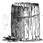
Continuing the description of the large village, Maximilian wrote: “The huts, as I have before remarked, stand close to each other, leaving, in the centre, an open circular space, about sixty paces in diameter, in the centre of which (among the Mandans) the ark of the first man is set up, of which we shall speak in the sequel. It is a small cylinder, open above, made of planks, about four or five feet high. fixed in the ground, and bound with climbing plants, or pliable boughs, to hold them together. (see the woodcut, [figure 5]).
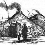
“At the north end of this circular space is the medicine lodge, in which festivals are celebrated, and certain customs practiced, which are connected with the religious notions of this people. At the top of a high pole, a figure is here placed, made of skins, with a wooden head, the face painted black, and wearing a fur cap and feathers, which is intended to represent the evil spirit, Ochkih Hadda. Other grotesque figures, made of skins and bundles of twigs, we saw hanging on high poles, most of them being offerings to the deity. Among the huts are many stages of several stories, supported by poles, on which they dry the maize. The huts themselves are of a circular form, slightly vaulted, having a sort of portico entrance. When the inmates are absent the entrance is shut up with twigs and thorns; and if they wish merely to close the door they put up a skin stretched out on a frame, which is shoved aside on entering. In the centre of the roof is a square opening for the smoke to find vent, over which is a circular sort of screen made of twigs, as a protection against the wind and rain, and which, when necessary, is covered with skins (see woodcut [figure 6] ).
“The interior of the hut is spacious, tolerably light, and cleanly. Four strong pillars towards the middle, with several cross beams, support the roof. The inner circumference of the hut is formed by eleven or fifteen thick posts, four or five feet in height, between which other rather shorter ones are placed close to each other. On these shorter posts, which are all of an equal height, are long rafters, inclining to the centre; they are placed near each other, and bear the roof. On the outside the huts are covered with a kind of mat, made of osiers, joined together with bark, and now the skeleton of the hut is finished. Over this hay is spread, and the outer covering is of earth. The men and women work together in erecting these huts, and the relations, neighbors. and friends, assist them in the work. In the centre of the hut a circular place is dug for the fire, over which the kettle is suspended. This fire-place, or hearth, is often enclosed with a ledge of stones. The fuel is laid, in moderately thick pieces, on the external edge of the hearth, crossing each other in the middle, when it is kindled, and the pieces gradually pushed, in as they burn away. The Indians are not fond of large fires. The inmates sit round it, on low seats, made of peeled osiers, covered with buffalo or bear skin. Round the inner circumference of the hut lie or hang the baggage, the furniture, and other property, in leather bags, the painted parchment traveling bags, and the harness of the horses; and on separate stages there are arms, sledges, and snow-shoes, while meat and maize, piled up, complete the motley assemblage.” 7
Among the many interesting paintings made by Bodmer during his journey with Maximilian is one of the large Mandan village, plate 39, looking down the Missouri, showing the cluster of earth lodges on the summit of the cliff which terminates abruptly at the river. A structure rather lower than the others, on the immediate edge of the level area, is probably the “bastion,” as represented in the plan, figure 4 (see above), pointing out over the cliff. Beyond the village, but evidently screened from view by the high cliff upon which the latter stood, was Fort Clark, near the mouth of a small stream which flowed into the Missouri.
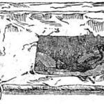
In these large circular structures the beds stood against the wall and the single opening faced inward. These were described by Catlin and clearly indicated in his drawing of an interior of a lodge, plate 38a. In Maximilian’s work is a sketch of such a bed which shows it as a unit, not attached to the wall, and capable of being moved about. The sketch is reproduced in figure 7. These were so formed and inclosed in skins as to protect the occupants from the cold blasts of air which must have circulated about in the interior of the lodge during certain seasons of the year. And as additional protection “In the winter huts they place, at the inside of the door, a high screen of willow boughs, covered with hides, which keeps off the draught of air from without, and especially protects the fire.” And Maximilian related how, about the middle of November or before, the Indians removed to their winter huts which were in a timbered area, and thus more protected from the winds and storms of winter. There they remained until the latter part of February, or the beginning of March, being governed by the climatic conditions. Thus about four months of the year would be spent in their winter village. As the greater part of their possessions would be deposited in underground caches they made frequent trips between their villages to get what was desired-food, clothing, skins, and other supplies. In the winter, when the frozen prairie was covered with ice and snow, they made use of sledges drawn by dogs to transport their goods from place to place.
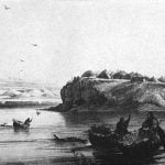
The sledges were “made of a couple of thin, narrow boards, nine or ten feet in length, fastened together with leather straps, and with four cross-pieces, by way of giving them firmness.”
On the evening of November 30, 1833, Maximilian returned to Fort Clark from a visit of a few days to the villages a short distance above. They passed through “the forest-village belonging to the inhabitants of Ruhptare,” referring to the winter village of the people of the smaller Mandan town. They entered one of the winter lodges, and “there was an abundance of meat hanging up in this hut, as they had had a very successful buffalo hunt.” After returning to Fort Clark Maximilian wrote: “The Mandan village near the fort was now entirely forsaken by the inhabitants. The entrances to the huts were blocked with bundles of thorns; a couple of families only still remained, one of which was that of Dipauch, whom Mr. Bodmer visited every day, in order to make a drawing of the interior of the hut. Instead of the numerous inhabitants, magpies were flying about, and flocks of snow buntings were seen in the neighborhood about the dry plants of the prairie, where the Indian children set long rows of snares, made of horsehair, to catch them alive.” The drawing made by Bodrner of the interior of the lodge proves to be one of his most interesting pictures. It was reproduced as plate XIX, and is here shown in plate 40.
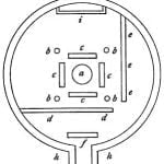
The people of Mih-tutta-hang-kusch having removed to their winter settlement, prepared to have “a great medicine feast,” and Maximilian was invited to be present, and so, as he recorded in his narrative, “we proceeded thither, on the 3rd of December, in the afternoon. Mr. Kipp took his family with him, and Mato-Topé and several other Indians accompanied us. We were all well armed, because it was asserted that a band of hostile Indians had been seen among the prairie hills on the preceding day. Our beds, blankets, and buffalo skins were laid on a horse, on which Mr. Kipp’s wife, a Mandan Indian, rode. Thus we passed, at a rapid pace, through the prairie, along the Missouri, then below the hills, which are pretty high. After proceeding about an hour and a half we reached the village in the wood, which is the winter residence of the inhabitants of Mih-Tutta-Hang-Kush. We stopped at the hut of Mr. Kipp’s father-in-law, Mandeek-Suck-Choppenik (the medicine bird), who accommodated us with a night’s lodging. The description of this hut may serve for all the winter huts of these Indians. It was about twenty paces in diameter, and circular; h is the fence or wall of the hut, supported inside by strong, low posts, on which rests the vaulted roof, which has a square hole to let the smoke escape; g is the entrance, protected by two projecting walls covered above. At f is the door, consisting of a piece of leather stretched on a frame. At d d there is a cross wall of considerable height, made of reeds and osier twigs woven together, to keep off the draught of air. At e e e there is another cross wall, only three feet high, behind which the horses stand; a is the fireplace, round which, at c c c c, are the seats of the inmates, consisting of benches formed of basket-work, covered with skins; b b b b are four strong pillars which bear the roof, and are very well united above by cross beams. At i there was a large leather case for the beds in which the family slept. A chain, with a large kettle, was suspended from the roof over the fire, to cook our supper, consisting of very pleasant flavored sweet maize.” A plan of the lodge reproduced here as figure 8.
The “great medicine feast” was to begin the evening of their arrival at the winter village and to last 40 nights. That evening “after seven o’clock we repaired to the medicine lodge; it was entirely cleared, except that some women sat along the walls; the fire burned in the centre, before which we took our seats, near the partition d d, with several distinguished men of the band of soldiers. At our left hand, the other soldiers, about twenty-five in number, were seated in a row; some of them were handsomely dressed, though the majority were in plain clothes. They had their arms in their hands, and in the centre were three men who beat the drum.” The lengthy detailed account of what followed during the course of the “feast” is most interesting, but will not be mentioned in this sketch.
As among the many neighboring tribes of the Missouri Valley the buffalo served as the principal source of food for the Mandan. Often sufficient meat could be secured very near the towns; again it would be necessary to undertake long journeys in search of the moving herds. It will be recalled that on January 13, 1805, when the mercury stood 34° below zero, Lewis and Clark saw “nearly one half of the Mandan nation” pass down the frozen Missouri on a hunt to last several days. And a few years later, just at the beginning of summer, June 25, 1811, Brackenridge wrote: “At ten, passed an old Mandan village; and at some distance above, saw a great number of Mandan Indians on their march along the prairie. They sometimes go on hunting parties by whole villages, which is the case at present; they are about five hundred in number, some on horseback, some on foot, their tents and baggage drawn by dogs. On these great hunting parties, the women are employed in preserving the hides, drying the meat, and making a provision to keep. Very little of the buffalo is lost, for after taking the marrow, they pound the bones, boil them, and preserve the oil.” 8 On such trips away from their permanent earth-lodge villages the Mandan made use of the skin-covered tipi.
In addition to the food supplied by the chase the people of the permanent villages had large gardens in which they raised quantities of corn and beans of various sorts, gourds and sunflowers of several varieties, and of the seeds of the latter “very nice cakes are made.” Many animals in addition to the buffalo, and various plants besides those cultivated in the gardens, served the Mandan for food.
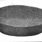
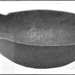
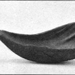
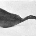
At the time of Catlin’s and Maximilian’s visits to the Mandan the latter were making and using their primitive forms of utensils such as had been in use for generations. Wooden mortars, bowls hollowed out of hard knots, spoons made of the horn of buffalo and mountain sheep, and, most interesting of all, dishes and vessels made of pottery gill these were used in the preparation or serving of food. Some remarkable examples of wooden bowls made by the Mandan are now preserved in the collection of the United States National Museum, Washington. One of the most interesting is shown in plate 41c, and another, of simpler form but equally well made, in plate 41a. Both examples were evidently quite old even when collected. They are fashioned out of maple knots, worked thin and smooth, and are beautiful specimens. Large spoons, often termed “drinking cups,” were, as already mentioned, made of the horns of buffalo and mountain sheep. The former were extensively used by many tribes, and usually resembled the one shown in plate 42a. The spoons made of mountain-sheep horns were often much larger and thinner, of a yellowish hue, and the handles were frequently bent into form or decorated. A. very beautiful spoon of this sort is shown in plate 42b.
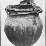
Pottery dishes and vessels, so Catlin wrote, “are a familiar part of the culinary furniture of every Mandan lodge, and are manufactured by the women of this tribe in great quantities, and modeled into a thousand forms and tastes. They are made by the hands of the women, from a tough black clay, and baked in kilns which are made for the purpose, and are nearly equal in hardness to our own manufacture of pottery; though they have not yet got the art of glazing, which would be to them a most valuable secret. They make them so strong and serviceable, however, that they hang them over the fire as we do our iron pots, and boil their meat in them with perfect success.” Maximilian described the art of pottery making among the Mandan as exactly like that of the two associated tribes, the Hidatsa and Arikara. He wrote regarding the three tribes that they “understand the manufacture of earthen pots and vessels, of various forms and sizes. The clay is of a dark slate color, and burns a yellowish-red, very similar to what is seen in the burnt tops of the, Missouri hills. This clay is mixed with flint or granite reduced to powder by the action of fire. The workwoman forms the hollow inside of the vessel by means of a round stone which she holds in her hand while she works and smoothes the outside with a. piece of poplar bark. When the pot is made, it is filled and surrounded with dry shavings, and then burnt, when it is ready for use. They know nothing of glazing.” This was probably the simple process of manufacture followed by the widely scattered tribes, and the apparent ease with which the vessels were made accounts for the great quantities of fragments now discovered scattered over ancient village sites. Two small vessels made by the Mandan, and collected by Dr. Matthews half a century ago, are in the National Museum collection, and one is shown in plate 41b. Very few perfect specimens exist, several being in the collection of the State Historical Society of North Dakota. The specimens in the National Museum are rather small, but some very large vessels were made and used in boiling their food.
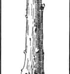
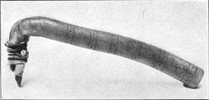
Bows and arrows were the principal weapons of the Mandan. The heads of the arrows, at the time of Maximilian’s stay among the people, were made of thin bits of iron, although persons then living remembered the use of stone. Lances and clubs were likewise made and used, and when mentioning the latter Maximilian said, “a simple, knotty, wooden club is called maunapanischa,” a woodcut, figure 9, of such a weapon. It is of interest to know that an example of this peculiar form of weapon, which at once suggests the traditional club of Hercules, is preserved in the Museo Kircheriana, in Rome. It is one of four specimens now belonging to the museum which were collected by Maximilian, the other three being a knife sheath, a horse bridle, and a saddle blanket, all being beautifully decorated with colored quillwork. The club is shown in figure 9, after a drawing made for the writer in 1905 by Dr. Paribeni, of the museum. The smaller end is bound or braided with tanned skin, to serve as a handle, and around the upper end of the wrapping is a band of quillwork similar in workmanship to that on the other objects. All are remarkably well preserved, and several specimens in the Ethnological Museum in Florence may have belonged to the Maximilian collection.
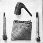
The Mandans, like other tribes of the upper. Missouri Valley, were very expert in the art of dressing skins, especially those of the buffalo. They used two forms of implements, one of which is similar to those shown in plate 12a; the second, rather more complicated, is represented in plate 34c. This is a beautiful old specimen now in the National Museum. The handle is formed of a piece of elk antler; the blade is of clear, brownish flint, well chipped. Other similar objects are preserved in the collection.
How fortunate it was that Catlin and Maximilian chose to spend much time among the Mandan during the years 1832, 1833, and 1834. A few years later, in the spring of 1837, the dreaded smallpox swept away the greater part of this most interesting nation, and “when the disease had abated, and when the remnant of this once powerful nation had recovered sufficiently to remove the decaying bodies from their cabins, the total number of grown men was twenty-three of women forty, and of young persons sixty or seventy. These were all that were left of the eighteen hundred souls that composed the nation prior to the advent of that terrific disease, and even those that recovered were so disfigured as scarcely to be recognized.” 9 Soon those who survived deserted their old village near Fort Clark and removed a few miles above, and the town was, about this time, occupied by the Arikara. It is interesting to know that the small remnant of the Mandan continued to follow their own peculiar customs and to maintain their tribal unity although so reduced in numbers. It will not be necessary in the present sketch to trace the later history of the tribe.
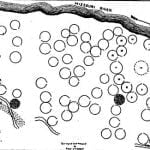
In recent years the State Historical Society of North Dakota has caused surveys to be made of the more important village sites in that State. In addition to the plans of the sites, showing the position of the earth lodges, they have been fortunate in obtaining drawings of the Mandan and Hidatsa villages, made by a Mandan living on the Fort Berthold Reservation. In writing of the picture and plan of the “most important historical site of the Mandan tribe in the state, the one visited and described by Lewis and Clark, Catlin, and Maximilian,” Libby said: “The Indian chart and the map of the village as it appears to-day are here shown. It is seen that the two representations are not essentially unlike. The grouping of the houses about a common center, at one side of which is the holy tepee, is the predominating characteristic of each.” The Indian drawing, although crude, shows some details omitted by Catlin in his many sketches; but the map figure 10 is of the greatest interest. A shows the site near Fort Clark as it appeared about the year 1908, and to quote from the description: “In the center of the tepees, on the space devoted by the old Mandans to the ‘big canoe’ and cedar post of the elder man,’ stands now a large tepee (shown in dotted outline) which was placed there by the Arikara who occupied the village after the small-pox scourge of 1837 had killed or driven away the original inhabitants.” The structures surrounding the open space were occupied by the principal men of the village, and the names as given by Libby were secured by him from ” Bad Gun, Rushing War Eagle, son of the Ma-ta-to-pe or Four Bears, whose portrait Catlin painted.” In the list of names “Tepee No. 1 was the holy tepee and was also used by Lance Shoulder,” and ” No. 2 was occupied by Four Bears.” The list includes fifteen names. At the time the survey was wade the entire ditch could not be traced, but its general course could be followed, thus indicating the approximate boundary of the town, “beyond which only a few tepees are located.” 10
When it is realized how little is known regarding the arrangement of the many ancient villages which once stood in the country east of the Mississippi, villages which in their time were probably as large and important as those of the Mandan of the last century, it is not possible to overestimate the value of the work of the Historical Society in causing to be made an accurate survey of the sites and in securing descriptions of the villages from some who remember them. A generation later this would not have been possible.
Citations:
- La Verendrye, Journal of. . . 1738-1739. In Report on Canadian Archives. . . 1889. Ottawa, 1890, p. 21.[
]
- Lewis and Clark, History of the Expedition under the command of Captains Lewis and Clark. . . Prepared for the press by Paul Allen. Philadelphia, 1814. 2 vols., I, pp. 112-114.[
]
- McDonnell, John, The Red River. In Masson Les Bourgeois de la Compagnie du Nord-Ouest. Premiere serie. Quebec, 1889 , pp. 272-273.[
]
- Mackenzie, Charles, The Mississouri Indians, a narrative of four trading expeditions to the Mississouri, 1804-1805-1806. In Masson Les Bourgeois de la Compagnie du Nord-Ouest. Premiere serie. Quebec, 1889, pp. 338-339.[
]
- Catlin, George, Letters and Notes on the Manners, Customs, and Conditions of the North American Indians. London, 1844. 2 vols., I, pp. 80-81.[
]
- Maximilian, Prince Of Wied. Travels in the Interior of North America. London, 1843, p. 171.[
]
- Maximilian, Prince Of Wied, Travels in the Interior of North America. London, 1843, pp. 342-344.[
]
- Brackenridge, H. M., Views of Louisiana; together with a Journal of a Voyage up the Missouri River, in 1811. Pittsburgh, 1814., p. 260.[
]
- Hayden, F. V., Contributions to the Ethnography and Philology of the Indian Tribes of the Missouri Valley. In Transactions of the American Philosophical Society, Vol. XII. Philadelphia, 1862, p. 433.[
]
- Libby, O. G., Typical Villages of the Mandans, Arikara, and Hidatsa in the Missouri Valley, North Dakota. In Collections of the State Historical Society of North Dakota. Vol. II. Bismarck, 1908, pp. 498 499.[
]
