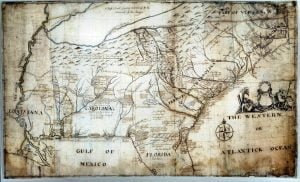
Captain John Barnwell, otherwise known as Tuscarora Jack, was a well known frontier settler who was active in the 1711 Tuscarora War. His travels throughout the Southeast enabled him to draw a relatively accurate map of the area of his travels and exploration, some from second hand information, but most from first hand. For researchers of the Southeast this map is critical, and never before seen online in such a large form as to be able to read the hand writing and personal descriptions and historical details as outlined by Barnwell. In order to view this map in a form that made it legible you had to travel to one of the two locations the actual versions exist.
Marilyn Rae, a member of People of One Fire, arranged to have a digital version of a high resolution photograph donated to People of One Fire, and they have provided that version for usage for AccessGenealogy (and People of One Fire) visitors.
The People of One Fire, head honcho, Richard Thornton, makes the following interesting points in a People of One Fire Newlsetter:
Three things are particularly significant.
- It labels the Georgia Mountains: A high range of mountains reaching to the Charokee Country, called the Appalachian by the Spanyards. It shows the Georgia Mountains to be occupied by the Coosate (Upper Creeks.) Thus we now have maps from 1721 to 1780 all showing the Georgia Mountains to be Upper Creek Territory
- It labels the Altamaha River . . . The Altamaha, St. George or May River.
- It labels the St. Johns River in Florida, the St. Johns River.
