In 1890, California’s Native American population was recorded in both the general census and a special census focused on reservations. The census data identified 11,517 self-supporting, taxed Native Americans living across various counties, primarily in Northern and Central California. Additionally, 5,064 Native Americans living on reservations, who were not included in the general census, were recorded separately. These populations were grouped under several agencies, including the Mission-Tule Consolidated Agency and the Round Valley Agency, each managing various tribes and reservations. This data provides a detailed view of the distribution and classification of California’s Native American population during this period, highlighting the diverse tribal affiliations and the distinctions between reservation and non-reservation communities.
The civilized (self-supporting) Indians of California, counted in the general census, number 11,517, 5,902 males and 5,015 females, and are distributed as follows:
Alpine County, 224; Amador County, 58; Butte County, 319; Calaveras County, 77; Colusa County, 277; Del Norte County, 376; Eldorado County, 136; Fresno County, 347; Humboldt County, 1,379; Inyo County, 850; Kern County, 337; Lake County, 556; Lassen County, 335; Los Angeles County, 114; Marin County, 31; Mariposa County, 152; Mendocino County, 581; Merced County, 30; Modoc County, 499; Mono County, 368; Monterey County, 58; Nevada, County, 159; Placer County, 73; Plumas County, 374; Sacramento County, 40; San Benito County, 41; San Bernardino County, 399; San Diego County, 478; San Francisco County, 31; San Luis Obispo County, 47; Santa Barbara County, 73; ‘Shasta County, 693; Siskiyou County, 710; Sonoma County, 297; Tehama County, 101; Trinity County, 193; Tulare County, 178; Tuolumne County, 218; Ventura County, 91; Yolo County, 41; other counties, with 27 or less in each, 116.
Total Californian Indian Population as of June 1, 1800
| Reservation Indians, not taxed (not counted in the general census) | 5,061 |
| Indians in prisons, not otherwise enumerated | 43 |
| Indians off reservations, self-supporting and taxed (counted in the general census) | 11,517 |
| Total | 16,624 |
The self-supporting Indians taxed are included in the general census. The results of the special Indian census, to be added to the general census are:
| Reservation Indians, not taxed | 5,064 |
| Indians in prisons, not otherwise enumerated | 43 |
| Other persons with Indians, not otherwise enumerated | 161 |
| Total | 5,268 |
Indian Population of California Reservations
| Agencies and Reservations | Tribe | Total | Males | Females | Ration Indians |
|---|---|---|---|---|---|
| MIssion-Tule Consolidated Agency | 4,483 | 2,295 | 2,188 | 28 | |
| Round Valley Agency | 581 | 294 | 287 | 147 | |
| Total | 5,064 | 2,589 | 2,475 | 175 | |
| Mission-Tule Consolidated Agency | 4,483 | 2,295 | 2,188 | 28 | |
| Hoopa Valley reservation | Hoopa | 408 | 209 | 259 | |
| Mission reservations (19 in number) | 2,6451 | 1,346 | 1,299 | 28 | |
| Tule River reservation | Tule | 162 | 81 | 81 | |
| Yuma reservation | Yuma | 1,2082 | 659 | 549 | |
| Round Valley Agency: | |||||
| Round Valley reservation | Various small tribes | 581 | 294 | 287 | 147 |
Tribe, Stock, and Location of the Indians in California
| Tribes | Stock | Reservation | Agency |
|---|---|---|---|
| Clear Lake | Yukian | Round Vall | Round Valley |
| Coahuila | Shoshone | Mission | Mission Tule Consolidated |
| Diegueno | Yuman | Mission | Mission Tule Consolidated |
| Healdsburg | Yukian | ||
| Hunsatung | Athapasca | Hupa (Hoopa Valley) | Hupa (Hoopa) Valley |
| Hupa | Athapasca | Hupa (Hoopa Valley) | Hupa (Hoopa) Valley |
| Kawia (Cahuilla) | Shoshone | Tule River | Mission Tule Consolidated |
| Kings River | Mariposan | Tule River | Mission Tule Consolidated |
| Klamath | Lutuamian | Klamath River | Mission Tule Consolidated |
| Klamath | Lutuamian | Hupa (Hoopa) Valley | Hupa (Hoopa) Valley |
| Klamath | Lutuamian | ||
| Koakau | Pujunan | Round Vall | Round Valley |
| Little Lake | Yukian | Round Vall | Round Valley |
| Miskut | Athapasca | Hupa (Hoopa) Valley | Hupa (Hoopa) Valley |
| Mission: | |||
| Coahuila | Shoshone | Mission | Mission Tule Consolidated |
| Dieguen | Yuman | Mission | Mission Tule Consolidated |
| Owongo (Owens River) | |||
| San Luis Rey | Shoshone | Mission | Mission Tule Consolidated |
| Serrano | Shoshone | Mission | Mission Tule Consolidated |
| Monnche | Shoshone | Tule River | |
| Pitt River | Palaihnihan | ||
| Pitt River | Palaihniha | Round Vall | Round Valley |
| Potter Valley | Kulanapan | ||
| Potter Valley | Kulanapan | Round Vall | Round Valley |
| Redwood | Athapasca | Hupa (Hoopa) Valley | Hupa (Hoopa) Valley |
| Redwood | Athapasca | Round Vall | Round Valley |
| Saiaz | Athapasca | Hupa (Hoopa) Valley | Hupa (Hoopa) Valley |
| San Luis Rey | Shoshone | Mission | Mission Tule Consolidated |
| Sermunalt | Athapasca | Hupa (Hoopa) Valley | Hupa (Hoopa) Valley |
| Serrano | Shoshone | Mission | Mission Tule Consolidated |
| Smith River | Athapascan | ||
| Tejon | Mariposan | Tule River | Mission Tule Consolidated |
| Temekula | Shoshone | Mission | Mission Tule Consolidated |
| Tishtanata | Athapasca | Hupa (Hoopa) Valley | |
| Tule and Tejon | Mariposan | Tule River | Mission Tule Consolidated |
| Ukiah | Yukian | ||
| Wailakki | Athapasca | Round Valley | Round Valley |
| Wichumne | Mariposan | Tule River | Mission Tule Consolidated |
| Yuki | Yukian | Round Valley | Round Valley |
| Yuma | Yuman | Yuma | Mission Tule Consolidated |
Round Valley Agency
The Concow, Little Lake, Pitt River, Potter Valley, Redwood, Tilde, Wylackie, and Nome Lackie bands have been on the Round Valley reservation since 1860.
The Concows came, from Butte County, Sierra Nevada Mountains. The Little Lakes, Potter Valleys, Redwoods, Ukies and Wylackies are natives of this county. The Pitt Rivers came from Lassen, Modoc, and Shasta Counties. The Nome Lackie Indians came from Tehama County. These were the locations of these Indians when discovered by Europeans,-T. F. Willsey, United States Indian agent
Mission-Tule Consolidated Agency
Hoopa Valley Reservation
The Hoopas are the only Indians on this reservation except 3 or 4 women of the Klamaths who have married natives here. They have no tradition that they, have ever lived elsewhere. Some of them even now locate the place where the first man lived, who came from the moon and established the Hoopas in this valley. Some years ago a small band of Hoopas who had lived some 15 miles from the agency were sent to the Round Valley reservation, but all of them have returned. Some of them are on this reservation now and some live outside of it.-Isaac A. Beers, United States Indian agent.
Mission Indians and Yuma and Tule River Reservations
For convenience, the Mission-Tule Consolidated Indian agencies located at Colton, at the junction of the Atchison, Topeka and Santa Fe and the Southern Pacific railroads. The reservations under this agency are widely scattered. The Hoopa Valley reservation is in the northern portion of the state. The Yuma reservation is along the Colorado River, 200 miles southeast of Colton. The Yumas are of Yuman stock and are the aborigines of that region. They are the most primitive in manners and customs of all the California Indians.
The Tule River Indians are on a reservation 200 miles north, and are a remnant of the Tejon tribe of Mission Indians who were removed to that point by United States troops some 40 years ago from the western end of the Mohave desert, near the Tejon pass. All the other Indians belonging to the agency, including the Mission Indians on the 19 reservations, are of the original Coast Indians of California, and as their ancestors came under the influence of the teachings of the Roman Catholic Church at an early day, they are properly designated as Mission Indians. Their reservations are from 30 to 150 miles from the agency. The small tribes are so intermingled that it is almost impossible to remember more than a few of the original names, as, for instance, the Coahuilas, Dieguenos, Serranos, and San Luisenos. These are the only original tribal names. All except the Yumas and Tule River Indians are in San Bernardino and San Diego Counties, and have always been there. There is scarcely a pure blood of any tribe left.–Horatio N. Rust, United States Indian agent.
Enrollment Of The Mission Indians
At the census of 1800 an attempt was made to enumerate the Mission Indians by villages or tribes, and to note the number of the 4 principal bands. It was found to be impossible for any one to enumerate the different tribes or families of Mission Indians, for the reason that they had intermarried for so many years and had kept no records. Those enumerated as Cabezone’s band were called so because he had control over the Mission Indians living on the desert, and he refused to have them counted. The count was made, however, by an enumerator, who used a handful of shot for the purpose, transferring the shot from one pocket to the other as the Indians were assembled for a feast.
Except the Yumas, all of the Indians in the southern counties of California are called “Mission Indians”.
The Tule River (Mission Indians) reservation is in Tulare County. The Morengo, or Portero, near Banning, is in San Bernardino County. The Yuma reservation (Apache) is in San Diego County, as are all the rest of the 19 Mission reservations.
It was found impossible to give the population of each reserve, for the reason that it was necessary to enroll the Indians wherever they could be found, and they are migratory. At times there are 150 Mission Indians at Riverside, and they may belong to 5 or 6 reservations. A man may belong at Coahuila and his wife at Sabola, and so on.
Mission Indians and the 19 Mission Indian Reservations
Mission Indians is the name of those Indians in California who lived under the charge of the Franciscan fathers at or near missions from and after 1760, the date of the founding of the mission of San Diego de Al mil a, at San Diego by Father Junipero. The term includes not only those who were under the care of the mission fathers, but is the name used to this day to designate the descendants of such Indians. The United States authorities, however, use it for or apply it to such Indians descended as above and living in the 3 southernmost counties of the state of California. They are grouped in 4 bands: the Coahuilas, Dieguenos, San Luisenos, and Serranos. Their residence about or attachment to a mission sometimes gave them a name: San Luisenos from San Luis Rey mission, and Dieguenos from San Diego mission.
Two recent censuses of these 4 bands are given as follows:
| Bands | 1880 | 1885 |
|---|---|---|
| Cohuilas | 675 | 667 |
| Dieguenos | 731 | 855 |
| San Luisenos | 1,120 | 1093 |
| Serranos | 381 | 481 |
| Total | 2,907 | 3,096 |
These Indians are now on 19 reservations in California, set apart by the United States for their use, the smallest containing 80 acres, the largest 88,475 acres; in all a total of 182,315 acres. Only about 5,000 acres are tillable. These reservations and the Mission Indians are in charge of the United States Indian agent at Colton, California. Rations were issued to but 28 Mission Indians in 1890. They are self-supporting.
Population of California Missions
At several periods the population of the California Indian missions is variously stated. In 1842 De Mofras, gave the population of the missions at 4,450. This was after the secularization of the missions in 1833-1834.
In 1888 Hon. John D, C. Atkins, Commissioner of Indian Affairs, reported on the Mission Indians as follows:
They are divided among the several reservations (as near as elm be ascertained from the census reports) as follows:
| Mission Indians | Acres | Numbers | Band |
|---|---|---|---|
| Agua Caliente, or Warner’s Ranch | 179 | San Luis Rey | |
| Agua Caliente | 60,875.80 | 38 | Coahuila |
| Cabezone | 622.22 | 186 | Coahuila |
| Capitan Grande | 17,340.51 | 57 | Dieguenos |
| Coahuila | 16,660.52 | 236 | Coahuila |
| Cosmit | 80.00 | ||
| Inaja | 100.00 | 59 | Dieguenos |
| Marengo, or San Gorgenio | 88,475.32 | ||
| Mesa Grande | 120.00 | 111 | Dieguenos |
| Mission | 1,920.00 | ||
| Pala | 160.00 | 66 | San Luis Rey |
| Portrero | 12,164.36 | 102 | Serranos |
| San Jacinto | 3,176.06 | 176 | Serranos |
| San Luis Rey | 2,072.81 | 45 | San Luis Rey |
| Santa Ysabel | 14,765.53 | 144 | Dieguenos |
| Sycuan | 640.00 | 51 | Dieguenos |
| Temecula | 3,200.00 | 157 | San Luis Rey |
| Torras | 639.00 | ||
| Village | 640.00 | ||
| Village | 642.40 |
Where the band is left blank in the above table (6 reservations) it has been impossible, from the data at hand, to identify the band or tribe occupying the reservation.
The census reports for 1886 show the following villages of Indians not included within reservations, so far as appears from the records:
| Indian Villages | Number | Tribe |
|---|---|---|
| La Jola | 136 | San Luis Rey |
| Rincon | 164 | San Luis Rey |
| San Ysadro | 60 | San Luis Rey |
| La Pueria | 87 | San Luis Rey |
| Pauma | 75 | San Luis Rey |
| El Monte | 60 | Coahuila |
| San Diequito | 21 | Dieguenos |
| San Felipe | 73 | Dieguenos |
| La Peacha | 42 | San Luis Rey |
| Mesa | 23 | Dieguenos |
| Coyote | 87 | San Luis Rey |
| Ahnanga | 18 | San Luis Rey |
| La Puerta de la Cruz | 26 | San Luis Rey |
| San Marguerita | 10 | San Luis Rey |
| San Jose | 27 | Dieguenos |
| San Pasqual | 48 | Dieguenos |
| Matajuay | 35 | Dieguenos |
| Los Cornejos | 80 | Dieguenos |
| Indians living at or near Pomona | 29 | Dieguenos |
| Riverside | 88 | Coahuila |
| San Diego | 99 | Dieguenos |
| San Bernadino | 203 | Serranos |
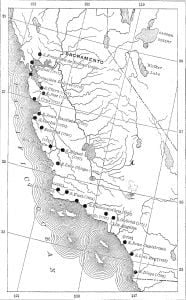
The census of 1890 shows a total Mission Indian population of 2,645, including 167 of Cabezone’s band of wandering Mission Indians. The Mission Indian population on reservations in California in 1890 was 2,478. The map of these mission reservations gives the details.
Citations:
- Includes Cabezone’s Band of Mission (Desert) Indians, numbering 167.[
]
- Enumerated in February, 1891; estimated in November, 1890 at 997, 501 males and 496 females.[
]


