Cornplanter Reservation and Occupants, 1890

This reservation, in Warren County, Pennsylvania, nominally a tract of 640 acres, owned by Cornplanter‘s heirs, lies on both sides of the Allegheny River, and is about 2 miles long and half a mile wide, including Liberty and Donation Islands, which are formed by the forking of the river. The land surface, including the riverbed and some worthless shoals, contains about 760 acres. It was a donation to the celebrated chief Gy-ant-wa-hia, “The Cornplanter“, March 16, 1796, by the state of Pennsylvania, in consideration, states Judge Sherman, “for his many valuable services to the white people, and especially that most … Read more

Religion of the Six Nation Tribes

With the exception of the Tuscaroras, each of the Six Nations has one or more council houses, in which the people assemble for business or purely Indian ceremonies, religious or social. There is also a council house or town hall on the Mount Hope road of the Tuscarora reservation, but the pagan party has no footing among this people. The council houses, formerly built of logs, are practically in disuse, and frame buildings, about 40 by 80 feet, with fireplace or simple chimney at each end, which allows separate sittings for the sexes, have taken their place. A new building … Read more

Reservations of the Six Nations in New York and Pennsylvania, 1723-1890

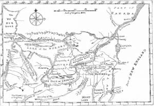
Map of the Country of the Five Nations

The accompanying map was prepared in 1771 under the direction of William Tryon, captain general and governor in chief of the province of New York, and is as nearly suggestive of the then recognized boundary of the Six Nations as any that has had official sanction. In 1851 Lewis H. Morgan, assisted by Ely S. Parker, a Seneca chief; and afterward an efficient staff Officer of General Grant, and the Commissioner of Indian Affairs, prepared a map for a volume entitled League of the Iroquois, which aimed to define the villages, trails, and boundaries of the Five Nations as they … Read more