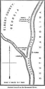
Near the close of a spring day in 1776, Mr. William Bartram, who, at the request of Dr. Fothergill, of London, had been for some time studying the flora of Carolina, Georgia, and Florida, forded Broad River just above its confluence with the Savannah, and became the guest of the commanding officer at Fort James. This fort was situated on an eminence in the forks of the Savannah and Broad, equidistant from those rivers, and from the extreme point of land formed by their union. Fort Charlotte was located about a mile below, on the left bank of the Savannah. The stockade of Fort James was an acre in extent.
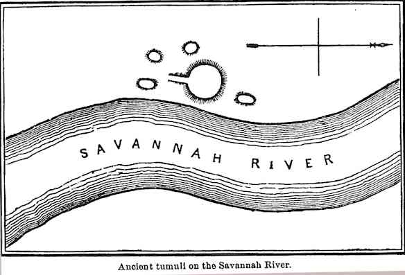
Attended by the polite surgeon of the garrison, Bartram made an excursion up the Savannah River, “to inspect some remarkable Indian monuments,” four or five miles above the fort. Of them he writes as follows: “These wonderful labors of the ancients stand in a level plain very near the bank of the river, now 20 or 30 yards from it. They consist of conical mounts of earth, and four square terraces, &c. The great mount is in the form of a cone, about 40 or 50 feet high, and the circumference of its base two or three hundred yards, entirely composed of the loamy, rich earth of the low grounds; the top or apex is flat; a spiral path or track leading from the ground up to the top is still visible, where now grows a large, beautiful spreading red cedar 1. There appear four niches excavated out of the sides of the hill, at different heights from the base, fronting the four cardinal points; these niches or sentry-boxes are entered from the winding path, and seem to have been meant for resting places or lookouts. The circumjacent grounds are cleared 2 and planted with Indian corn at present, and I think the proprietor of these lands, who accompanied us to this place, said that the mount itself yielded above one hundred bushels in one season. The land hereabouts is indeed exceeding fertile and productive.”
Unable satisfactorily to determine the precise object the aborigines had in contemplation in the erection of this striking monument, he hazards the conjecture that the Indians formerly possessed a town on the river bank, and raised this mound as ” a retreat and refuge in case of inundations, which are unforeseen, and surprise them very suddenly, spring and autumn.”

Wishing to note the changes which might have occurred during the past hundred years, we visited these tumuli a few weeks since. The attendant mounds, which are mainly grave-mounds, had been materially wasted by the plowshare and the influences of the varying seasons. The tetragon terraces had lost their distinctive outlines, and were little more than gentle elevations; their surfaces littered with shreds of pottery and flint chips, and occasionally with fragments of human bones. Freshets had sadly marred the level of the adjacent space. Over-leaping the river bank, the turbid waters had carved deep pathways in the surface of the valley on both sides of the “great mount.” There it remained, however, wholly unaffected by these unusual currents. It had evidently suffered no perceptible diminution in its recorded dimensions. The Savannah River still pursued its long-established channel, but “the four niches or sentry-boxes,” if they formerly existed, were entirely gone, and of “the spiral path or track leading from the ground up to the top” we could discover no trace. On the south a roadway, about 15 feet wide and commencing at a point some distance from the base of the mound, leads with a regular grade to the top. This manifestly furnished the customary means of ascent, as the sides are too precipitous for convenient climbing. This feature seems to have escaped Mr. Bartram’s observation.
Not having been cultivated for many years, the apex and sides of this truncated cone are now clothed in a luxuriant growth of trees and swamp cane. Attired in such attractive garb, this tumulus forms a marked object in the profile of the valley from which it springs. Proofs of long-continued occupancy, by the aborigines, of the adjacent territory are abundant. Ancient burial-places, the sites of old villages, traces of open-air work-shops for the manufacture of implements of jasper, quartz, chert, greenstone, and soapstone, refuse piles, and abandoned fishing resorts, are by no means infrequent along both banks of the Savannah River for many miles. Upon the advent of the European the circumjacent valley was found cleared and in cultivation by the red men, who here had fixed abodes and were associated in considerable numbers. The Southern tribes, in the sixteenth century, subsisted largely upon maize, beans, pumpkins, and melons. These they planted, tended, and harvested regularly. Of their agricultural labors at the dawn of the historic period we have full accounts.
So vast are the proportions of this largest mound that we are persuaded it rises beyond the dignity of an artificial place of retreat, elevation for chieftain-lodge, or mound of observation.

It appears entirely probable that it was a temple-mound, built for sun worship, and that it forms one of a well-ascertained series of similar structures still extant within the limits of the Southern States. These Florida tribes, as they were called in the days of De Soto, worshiped the sun and were frequently engaged in the labor of mound-building. Over them ruled kings who exercised powers well-nigh despotic. Often were the concentrated labors of the nation directed to the accomplishment of allotted tasks. Hence, within the territory occupied by these people, we find many traces of early constructive skill of unusual magnitude.
The material employed in erecting this large tumulus differs from the soil of the surrounding bottom. It is a dark-colored, tenacious clay, while the surface of the valley is covered with a micaceous loam readily dissolving into an almost impalpable powder. Nearby are no traces of pits or excavations. Nor are there indications that any earth was scraped up around the base. These facts afforded confirmation of the statement made by the present owner of the plantation upon which these tumuli are located, that the big mound had been built with clay brought from the Carolina side of the Savannah River. There clay abounds; and we were informed that in the side of the hill immediately opposite, the excavations may still be seen whence the tough material was obtained for heaping up this mound. This tumulus is one of the finest within the limits of Georgia, and should be classed with the truncated pyramids on Tumlin’s plantation in the Etowah Valley, with the largest of the East Macon mounds, and with that frustrum of a four sided pyramid on Messier’s place, in Early County.
Citations:

