History and Genealogy of Blue Hill, Maine

Historical Sketches of Bluehill Maine

From the record of the town’s annual meeting held “March 6, 1769”, we learn that it was “Voted that Joseph Wood, Jonathan Darling and Robert Parker be a Committee to lay out Roads where they should think proper to convean the Town on this side of the Salt Pond.” The year previous the town voted “For to clear a Rhode from here to Pronobscutt” and chose a committee consisting of Samuel Foster, Israel Wood, Robert Parker, Joseph Wood and John Roundy to attend to laying out said “Rhode”. At the annual town meeting held “Monday, April 7, 1794, voted that … Read more

The Settlers of Narraguagus Valley Maine

Narraguagus Valley Some Account of its Early Settlement and Settlers

A glance at the map of the western part of Washington County will show that any treatment of the early settlement upon the Narraguagus River, necessarily involves more or less of the histories of Steuben, Milbridge, Harrington and Cherryfield. Steuben was formerly township “No. 4, East of Union River,” and No. 5 comprised the territory now included in the towns of Milbridge and Harrington. The town of Cherryfield is composed of No. 11, Middle Division, Brigham Purchase, and of the northeastern part of what was formerly Steuben. All that part of Cherryfield lying south of the mills on the first … Read more

Record of Connecticut Men in the War of 1812

Title Page to War of 1812

Record of Connecticut men who served in the Regular Army and the Militia in the War of 1812 compiled from rosters on file in Adjutant-General’s Office, Washington D. C. by authority of the general assembly Record of Connecticut Militia in the War of 1812 compiled from rosters on file in Adjutant-General’s Office, Washington D. C. Abbreviations Record of Connecticut Militia in the War of 1812 Record of Connecticut Men in the Regular Army, War of 1812 Officers Enlisted Men  

Record of Service of Connecticut Men in the War of the Revolution

Title Page to Revolutionary War

The several rolls and lists in the following pages have been arranged chronologically according to the description of the service in which the troops engaged. Thus, after the first alarm, the Continental soldiers are classified in the order in which they were called out, then the State troops, and finally the Militia, with special lists following. Index to Record of Revolutionary Service Index to Military History – Battles, Camps, Orders The Lexington Alarm The first lists in the record, grouped under the head of the “Out-break of the War,” include the names of the men who, under the provocation of … Read more

Record of Connecticut Men in the Mexican War

Title Page

Record of Connecticut men who served in the Regular Army during the Mexican War compiled from rosters on file in Adjutant-General’s Office, Washington D. C. by authority of the general assembly  

The Native American History of Florida’s Lake Okeechobee Basin

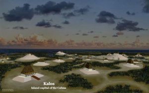
The Village of Calos

The Lake Okeechobee region contained some of the most sophisticated indigenous cultures that ever existed north of Mexico. Its towns built large earthworks and ponds in the shape of the ceremonial scepters carried by leaders in the Southeastern Ceremonial Mound Culture, but they were built several centuries before the Southeastern Ceremonial Mound Culture appeared elsewhere. Its engineers constructed several hundred miles of canals and raised causeways to interconnect the towns. They even built locks to enable cargo canoes to bypass rapids. Yet despite all this cultural precociousness, so far there is no evidence that the people of South Florida ever practiced large scale agriculture. However, intensive cultivation of raised garden beds in a semi-tropical climate, also a practice of the Mayas, may have produced a far higher percentage of their diet than anthropologists currently presume.

Appalachian Colonists from the Mediterranean Basin

1591 Floridae Americae Provinciae Map

Throughout the Southeastern United States can be found “old families” in rural areas whose appearance is not quite the same as the European or African peoples who colonized the region, but also not what a person with substantial indigenous ancestry looks like either. In earlier times they might have called themselves Cajun, Black Irish, Redbone, Black Dutch, Portughee, Old Spanish, Melungeon or Part Injun. In more recent years they are likely to say that their great-grandmother was a full blooded Choctaw, Cherokee, Creek, Chickasaw, Catawba, Shawnee or Blackfoot. She may have been, but that is not always the case. Many … Read more

Memoirs of a French Village: a chronicle of old Prairie du Rocher, 1722-1972

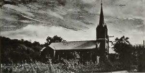
St. Joseph's, Prairie du Rocher

In summarizing or evaluating the history of Prairie du Rocher, one must note the impact that historical events and influences have made on present day, Prairie du Rocher. The community is today, as it was in the 1700′ s, basically an agricultural community. The farmers no longer live in the village, but they remain the basic economic factor in the village. The farm lands which surround Prairie du Rocher, are among the most fertile and bountiful soils in the world. The limestone bluffs, from which the French obtained stone for the construction of Fort Chartres, today provide livelihood for many of the villagers. The cemetery in which the inhabitants bury their dead in 1972 is the same one in which their ancestors buried their loved ones as early as 1722. The rock bluffs and the wide Mississippi River isolate the community from the outside world today, as they did in the early years. The mosquitoes remain as numerous and voracious as they were in 1839; and the damp, wet, unbearable, and unhealthy conditions return during the wet months. The population today is approximately 750, a gain of only 250 since 1859, over a hundred years ago. The old, distinctly French names such as Barbeau, Bievenue, Langlois, Louviere, De Rousse, and Duclos, still appear on the village registers, but the influence of the French is not limited to the inheritance of names. Over 90% of the residents today, belong to the Roman Catholic Church. The Church remains the center of the community. The majority of the villagers today, are complacent, contented, unambitious, good-natured, and happy – traits directly traceable to their ancestors. Most of the villagers remain to an amazing degree, as Montague described it, “free from that strife, contention, and turmoil, which attends the pursuit of wealth and political preferment.” In order to observe this living historical heritage, one need only attend the annual church picnic, rendezvous, or witness the group of villagers dressed in 18th century costumes, on New Year’s Eve, who move from house to house proclaiming the end of another year, in the old familiar words of the La Gui-annee.

History of the Choctaw, Chickasaw and Natchez Indians

Horatio Cushman

First published in 1899, “History of the Choctaw, Chickasaw and Natchez Indians” remains a seminal work on the indigenous tribes of the American Southeast. Authored by Horatio Bardwell Cushman, who was born to missionary parents and raised among the Choctaws starting in 1820, the book offers a unique and personal perspective on the lives and histories of these tribes. Cushman’s proximity and intimacy with the Choctaw and Chickasaw peoples, over nearly eighty years, lends his narratives an authenticity and depth seldom matched in other historical accounts.

Rood Creek Mounds

Roods Creek Mounds Site Plan

Rood Creek Mounds (also known as Roods Creek Mounds) is a very large Native American town site in southwestern Georgia that is immediately east of the Chattahoochee River in Stewart County. It was one of the largest Native American towns in the eastern United States. The original palisade enclosed about 120 acres and eight mounds. The final palisade enclosed at least eight mounds and 150 acres.   The archaeological zone is now within Rood Landing Recreation Area, a US Army Corps of Engineers facility on Lake Eufaula. Relatively little is known about this archaeological zone. Four mounds (A, B, D and … Read more

Indian Captivity Narratives

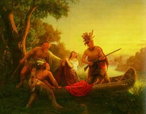
The Abduction of Daniel Boone's Daughter by the Indians

This collection contains entire narratives of Indian captivity; that is to say, we have provided the reader the originals without the slightest abridgement. Some of these captivities provide little in way of customs and manners, except to display examples of the clandestine warfare Native Americans used to accomplish their means. In almost every case, there was a tug of war going on between principle government powers, French, American, British, and Spanish, and these powers used the natural prowess of the Indians to assist them in causing warfare upon American and Canadian settlers. There were definitely thousands of captivities, likely tens of thousands, as the active period of these Indian captivity narratives covers 150 years. Unfortunately, few have ever been put under a pen by the original captive, and as such, we have little first-hand details on their captivity. These you will find here, are only those with which were written by the captive or narrated to another who could write for them; you shall find in a later collection, a database of known captives, by name, location, and dates, and a narrative about their captivity along with factual sources. But that is for another time.

History of the Indian Wars

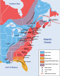
Map of French and Indian War

Our relations with the aboriginal inhabitants of this continent form a distinct and very important, and interesting portion of the history of this Republic. It is unfortunately, for the most part, a history of bloody wars, in which the border settlers have suffered all the horrors of savage aggression, and, in which portions of our colonial settlements have sometimes been completely cut off and destroyed. Other portions of this thrilling history, evince the courage, daring, and patience of the settlers, in a very favorable point of view, and exhibit them as triumphing over every difficulty, and finally obtaining a firm foothold on the soil. In all its parts, this history will always possess numerous points of peculiar interest for the American reader.

The Hudson River

View of Hudson River

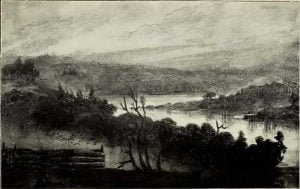
The Hudson River has played a prominent roll in the history of the State of New York and America. This collection of writings documents a writers sojourn along the Hudson River as he explains in poignant language the features, locations, history and tales of the Hudson River.

The Migration of Voyageurs from Drummond Island to Penetanguishene in 1828

Penetanguishene Bay

The story of the transfer of the British garrison from Drummond Island to Penetanguishene in 1828 and the migration of voyageurs connected with the post has never been told in print. In the following notes Mr. Osborne has endeavored to gather this story from the lips of the few survivors who migrated at that time. Descendants of French-Canadians largely predominated in this movement, but we also get glimpses of what a strange and heterogeneous people once gathered around Mackinaw and Drummond Island, especially about the time of the coalition of the two fur companies in 1821. The migrant voyageurs settled principally near Penetanguishene, in the township of Tiny, Simcoe County. Offshoots of the band settled at Old Fort Ste. Marie, at Fesserton and Coldwater, and another south of Lake Simcoe, near Pefferlaw, York County. These notes will form a useful supplement to Joseph Taase’s “Les Canadiens de l’Ouest.”

Registers of the Parish of Michilimackinac

Entry in Mackinac Registry 28 July 1768

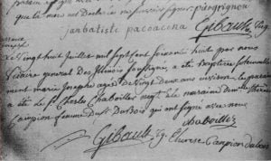
The records from the register at Michilimackinac are here provided as they were translated by Edward O. Brown back in 1889. His translation came from a transcript of the original, which latter is kept in the parish church of Ste. Anne, at Mackinac. Annotated throughout are Mr. Brown’s biographical knowledge of the events of Michilimackinac and the people within. Don’t pass over the footnotes for the record, you may find a biographical reference hidden there!

Map of Fort Mims

Map of Fort Mims

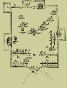
A copy of a map of Fort Mims. This map was found among the papers of General Claiborne. Block house. Pickets cut away by the Indians. Guard’s Station. Guard House. Western Gate. This Gate was shut, but a hole was cut by the Indians. Captain Bailey’s Station. Steadham’s House. Mrs. Dyer’s House Kitchen. Mims’ House. Randon’s House. Old Gate-Way — open. Ensign Chambliss’ Tent. Ensign Gibbs’. Randon’s. Captain Middleton’s. Captain Jack’s Station. Port-hole taken by Indians. Port-hole taken by Indians. Port-hole taken by Indians. Major Beasley’s Cabin. Captain Jack’s Company. Captain Middleton’s Company. Where Major Beasley fell. Eastern Gate, where … Read more

Detroit’s Original Colonists

Map of Detroit in 1708

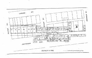
On the accompanying map I have placed numbers on the various lots to conform to the report made by Cadillac. They do not agree with the order of alienation, but all the transfers were made between 1707 and 1710. The names of the purchasers, arranged according to the numbers on the map, are also given, with the consideration for each parcel. The names are sometimes indefinite, for these Frenchmen had curious habits of changing their name, passing by different names at different times, and even in the little village Cadillac did not seem to know the first names of all … Read more

The Northern Cheyenne Reservation

Ledger drawing - Cheyenne and Pawnee or Osage fight

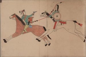
This report has been prepared by the Northern Cheyenne Tribe under contract with the Bureau of Land Management (“BLM”). The BLM was in the process of amending the Powder River and Billings Area Resource Management Plans to address large-scale development of coal-bed methane (“CBM”) resources in southeastern Montana, including lands in the vicinity of the Northern Cheyenne Reservation. The purpose of the report is to characterize those aspects of the Reservation environment and resources, social, economic, cultural and physical, which have the potential to be affected by CBM and other energy development on adjacent lands. By identifying lands, resources and services which are likely to be vulnerable to impacts, the report is intended to assist BLM in meeting its trust obligations to prevent and/or mitigate the impacts of off-Reservation development on the Tribe and its Reservation.

Crow Tribal Births 1949-1950

The following information details those children born on the Crow Reservation, Montana, from June 1949 to October 1950. Joseph Hedoesit, Jr.;  b. 6-14-49; degree of blood, 4/4; father, Joseph; mother, Laura Ida Tobacco; address, St. Xavier. Dennis Arthur Wilson; b. 6-16-49; degree of blood, -; father, -; mother, Nora Wilson; address, Crow Agency. Maralene L. Rideshorse; b. 6-21-4; degree of blood, 4/4; father, Samuel; mother, Fannie Otherblackbird, address, Pryor. Vincient Littlelight; b. 6-23-49; degree of blood, 15/16; father, Richard; mother, Theresa Teed; address, St. Xavier. Caroline M. Farwell; b. 7-2-49; degree of blood, -; father, Mark; mother, Hazel Frisch; address, … Read more

Indian Biographies

Sioux Chief Sitting Bull

Biographies are a good source of information on our ancestors. They can be used as a tool to provide facts: names, dates and locations for the events in our ancestors lives. They can also provide “meat” for genealogical research, and by that we mean the story behind the person – events which shaped and molded the character of a person. We have put a great number of biographical information online, both Native American and general biographies, and have gone through all of them and provided links to the one’s specific to Native American.