Delaware Ceremony, 1762

“I was present in the year 1762, at the funeral of a woman of the highest rank and respectability, the wife of the valiant Delaware chief Shingask; . . . all the honours were paid to her at her interment that are usual on such occasions. . . . At the moment that she died, her death was announced through the village by women especially appointed for that purpose, who went through the streets crying, ‘She is no more! She is no more!’ The place on a sudden exhibited a scene of universal mourning; cries and lamentations were heard from … Read more

Mesoamerican Geographical Names in the Southeast

Am Ixel: This is a Chontal Maya word, which means Place of the Goddess, Ixel. She was the goddess of fertility in Classic Maya times and also the goddess of the new moon in Post Classic times. Both the coastal plain of Tamaulipas State and the Gulf Coast between Mobile, AL & Cedar Key, FL were recorded by the Spanish as being named Amichel. Apparently, the Spanish never recognized the connection. Ixel was the favorite goddess of the Chontal Maya, who were considered illiterate barbarians by the Classic Period Maya. For them, she was also the patron ‘saint” of young, … Read more

Mesoamerican Words in Itsate

Both Itsate and Muskogee have borrowed words from other languages. In fact, Muskogee is the most aberrant of all the Muskogean languages. Prior to the European Colonial Period the Muskogee speakers were a minority among the ancestors of the Creeks, but rose rapidly to power after the Itsate provinces were almost wiped out by plagues and slave raids. The original homeland of the Muskogee in the East was a triangle along the middle section of the Chattahoochee river, eastward to the area around Macon, GA. Muskogee seems to have been a blend of Itsate with a non-Muskogean language spoken along … Read more

Bottle Creek Mounds

About twenty miles north of Mobile, the Tensaw separates from the Mobile river, running to the east by a very tortuous course as far as Stockton, then to the south, emptying into the east side of Mobile bay. Between these two rivers is enclosed a tract of land, twenty miles long and about seven wide, consisting of marsh and swamp land. Much of it is impassable; some of it quakes and sinks beneath the tread, and is covered with tall grass and aquatic plants; the larger portion supports heavy forests, and is called swamp land. Only small portions of the … Read more

The Native American Holocaust

The population of Mexico began to drop almost immediately after the arrival of the Spanish in 1519. A smallpox plague devastated the population of Tenochtitlan while it was under siege by the Spanish. Many other European diseases spread across Mexico and Central America in the years that followed.  Even prior to the Cortez Expedition, a smallpox plague devastated the Yucatan Peninsula, the Caribbean Islands and the advanced peoples living around the Mobile and Pensacola Bays on the Southeastern Gulf Coasts. Several European plagues that swept through Mexico during the 1500s and early 1600s killed anywhere from 30% to 80% of … Read more

Mexican Native Americans

As mentioned, three major centers of advanced culture blossomed around 900 AD and quickly disappeared around 1150 AD.  They were the Toltec capital of Tula, the trade megapolis on the Ocmulgee River in central Georgia, and the cluster of towns connected by canals and raised bed roads around Lake Okeechobee.  The causes of their contemporary rise and fall have not been studied by archaeologists and geologists.  In fact, very few of these scientists seemed to be aware of the coincidence. Etula in northwest Georgia and Ichese in central Georgia continued to prosper for 50 years after the abandonment of the … Read more

The North Atlantic Tsunami

Between 2007 and 2012 scholars became aware of several archives and geological records, which described a catastrophic tsunami in the North Atlantic in 1014 AD. The date is especially relevant to the study of the Track Rock terraces. Currently, the oldest radiocarbon date for an agricultural terrace at Track Rock is c. 1018 AD – which actually could be 30 years in either direction. Forensic geologist Dallas Abbott of the Lamont Doherty Earth Observatory at Columbia University has found evidence of a large meteor or comet strike in the middle of the Atlantic Ocean, which hurled extraterrestrial debris over 3800 … Read more

Late Woodland Cultures in the Southeast

In the Southeast, construction stopped at large Swift Creek ceremonial towns such as Leake Mounds in Cartersville, GA and Kolomoki Mounds in extreme southwestern Georgia around 650 AD. Apparently, the populations of these towns dropped substantially. Swift Creek Culture village sites were established in the upper Piedmont and Southern Highlands during this time.  The Weeden Island Culture, which replaced Swift Creek in the Gulf Coastal Plain continued.  Many of its ceramics had a distinct Caribbean or northern South American “feel” to them. While the Middle Woodland Cultures in the Southeast seemed to be waning, the population and cultural development in … Read more

Toltecs

The Toltecs are associated with a single city, about 100 miles north of Mexico City. It is known today by the Totonac word for town, Tula.  However, that was also the probable name of Teotihuacan.  The city probably had another name.  The problem is now, anthropologists are not even sure what ethnic group lived there.  The city was contemporary with the Totonac and Huastec civilizations, but its architecture bears no resemblance to either.  What the architecture of Tula No. 2 does resemble is the Native American city in southern Illinois now called Cahokia.  Tula’s pyramids are earth and rubble veneered … Read more

Totonac Civilization

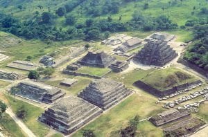
Aerial View of El Tajin

Shortly after the abandonment of Teotihuacan, cities began developing in northern Vera Cruz. The location of Teotihuacan had become quite arid as today, while Vera Cruz benefited from have a lower altitude and proximity to the Gulf of Mexico. The descendants of the builders of these cities called themselves the Totonacs and they claim to have also once been the elite of Teotihuacan. The architecture of these cities, the best known being El Tajin and Cempoala, shared some decorative details with Teotihuacan, but architectural forms and city plans were quite different.  The Totonacs learned how to make pozzolanic concrete.  This … Read more

Late Classic Maya Heartland

The populations of Maya cities and countryside exploded after the mid-Sixth century hiatus. Several cities reached over 100,000 people. According to NASA archaeologist Tom Sever, the Mayan civilization in Mesoamerica was one of the densest populations in human history. At its zenith around 800 AD, the total population was probably in the range of 22 million.  Prior to the analysis by NASA most archaeologists assumed that the total population was in the range of 10 million. Slavery: Paralleling the population growth was general affluence, which enabled the Maya elite to import and export commodities and artistic creations to and from … Read more

Tabasco and Chiapas

Chontalpa

The southern end of Vera Cruz and all of Tabasco in Mexico are not significantly different in appearance than southeastern Georgia.  Most of the region is level and humid, with many swamps and natural lakes. The coast of Tabasco is lined with tidal marshes almost identical to those of the coast of Georgia.  Although most of the indigenous inhabitants of Tabasco are called Mayas, most are descended from ethnic groups that were not true Mayas, but absorbed varying degrees of Maya culture.  One group, the Tamauli were originally refugees from Tamaulipas State in the northeastern corner of Mexico. This is … Read more

Indian Captives of Washington from the Vessel Georgiana

The names of the rescued captives, and vessel’s crew: William Rowland, captain Duncan McEwen, mate Benjamin and Richard Gibbs, sailors Tamaree, an Hawaiian cook Passengers Asher Sargent E. N. Sargent Samuel D. Howe Ambrose Jewell Charles Weed Daniel Show Samuel H. Williams James McAllister John Thornton Charles Hendricks George A. Paige John Remley Jesse Ferguson Ignatius Colvin James K. Hurd William Mahard Solomon S. Gideon George Moore B. F. McDonald Sidney S. Ford Jr Isaac M. Browne Mr. Seidner I find, besides the reports made at the time by S. D. Howe, George Moore, Captain Rowland, and subsequently by Charles … Read more

The Indigenous Peoples of Northern Georgia

Etowah Woman

During the earliest part of this Paleo-Indians period, an ice sheet covered the portion of North America above the Ohio River. Brasstown Bald probably had a permanent ice cap, while permafrost characterized its upper elevations. No evidence of glaciers has been found. The valleys around Brasstown Bald would have been similar in appearance to those near the mountains of New England and Southern Quebec today. This Late Sub-Boreal Period evolved into an Isothermal Period in which northern and southern plant species grew in proximity. Vegetation grew throughout much of the year. This made possible the large mega-fauna populations. Around 10,000 … Read more

Site Tour of the Track Rock Gap Archaeological Zone

Track Rock Site Tour

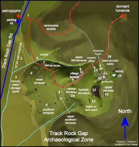
1 – Vent Trail: The entrance to the Vent Trail was only about 125 feet from Track Rock Gap Road.  The Vent Trail appeared to be an old logging road that varied from about eight to fourteen feet wide.  The trail’s lack of use had allowed dense stands of wild blackberries to grow up at the entrance along sections exposed to sunlight.  Since the trail leads to the dormant volcanic vent, it is also possible that centuries of foot and horse traffic have widened the original trail to the scale of a road. Until this point in time, we really … Read more

A Geospatial Analysis

Etowah 750 AD

As stated in Part Three, the Stratum Unlimited, LLC report in 2001 (Other Missing Stone Archaeological Sites) virtually ignored the Native American communities in northern Georgia. Almost all were contemporary with the occupation of the Track Rock Terraces. This omission was particularly inexcusable for the town sites that were adjacent to the two creeks, which flow off of Track Rock Gap, Town Creek and Arkaqua Creek.  In 1930s and 1940s, archaeologist George Wauchope found evidence of long term occupancy at these sites that apparently began before the Track Rock terraces were constructed, and sometimes continued into the Federal Period. It … Read more

Trade Routes in the Lower Southeast

The memoir of French explorer, René Goulaine de Laudonniére state that the predominate flow of trade in the Lower Southeast in the late 1500s was north-south.  Greenstone, gold, ocher, mica, crystals, precious stones and silver that was mined in the Southern Highlands, were traded for salt, shells, grain, skins, furs, colorful clays, dried fish and dyes obtained from lower altitudes.  He emphasized that the desire to control the cargos of greenstone and gold from the mountains was the cause of many wars. A major trade route passed through Track Rock Gap, but it was not the most important one. The … Read more

Apocalypto

I knew so little back then. I had only the slightest grasp of my Creek Indian heritage.  I couldn’t even begin to answer Dr. Piña-Chan’s questions.  I did tell him that we had a lot of gold in the Georgia Mountains, but our archaeologists said that the Indians didn’t know anything about it.  Even then, however, I agreed with Dr. Piña-Chan. Why would our Indians be so skilled with working copper, which is also abundant in some parts of the mountains, but not work gold? Well, anthropologists knew so little back then, too.  They were just beginning to translate Maya … Read more

Mayan and Creek Similarities

Many, many suns ago, I was awarded a fellowship by Georgia Tech to spend a summer studying the indigenous architecture and town planning of Mesoamerica. The grant involved visiting all of the major archaeological sites in Mexico, Guatemala and Belize. In addition, I was to photograph at least 2500 professional quality color slides for the Georgia Tech library.  The education I received seemed only a little relevant to an architectural career in the United States, but it would make interesting conversation for dates and parties.  Besides . . . Relaciones Exteriores (their State Department) let me ship home 125 kg … Read more

French Colonizing Expeditions

A small temporary fort was established by Captain Jean Ribault in Port Royal Sound, SC in 1562. Seventeenth Century French maps state that members of this colony traveled to the “gold-bearing mountains of the Apalache,” and claimed the territory for the King of France. Only French maps of the period provide an accurate description of the entire Savannah River system, but no archives have been found that collaborate such a journey. In 1564, after establishing Fort Caroline somewhere in the vicinity of the mouth of the Altamaha River, Captain René Goulaine de Laudonniére dispatched several expeditions up the Altamaha River … Read more