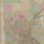
Sewall’s Map of Minnesota was entered according to Act of Congress in the year 1857, by J. S. Sewall. The map provides insight into the 19th century topographical history of Minnesota and Wisconsin, along with pinpointing the location of several Native American villages of the Chippewa and Sioux. The map was prepared for the purpose of land sales and the construction of the Lake Superior and Mississippi Railroad which was to be completed by June 1870.
The map is extremely detailed for such an early creation, and includes natural and man-made creations such as waterways, roads, railroads, and reservations. A large proportion of the map is also gridded showing the surveyed sections of the state at that time, especially the southern and eastern portion.
