Richmond Blues – Augusta Georgia

D. W. DILL, Captain. J. PHINIZY, 1st Lieutenant. A. H. MCLAWES, 2d Lieutenant. W. PHILLIPS, 1st Sergeant. D. D. MCMURPHY, 2d Sergeant. R. H. RINGGOLD, 3d Sergeant. J. F. GLOVER, 4th Sergeant. S. JOHNSON, 1st Corporal. H. BAKER, 2d Corporal. A. PHILLIP, 3d Corporal. G. GORDON, 4th Corporal. Privates. Francis Agnew Benjamin Ansley William Archy R. H. Bush John Bradey R. D. Bridges John Batly J. W. Berry P. Barret J. M. Brown John ‘PV. Conklin James Callahan F. C. Cattinet Joseph M. Collins Washington Collins Milton Cawley Timothy Crawley John C. Colo Patrick Cole M. M. Copeland N. M. … Read more

Columbus Guards – Columbus Georgia

JNO. E, DAVIES, Captain. JNO. FORSYTH, 1st Lieutenant. C. P. HERVEY, 2d Lieutenant. R. ELLIS, 1st Sergeant. J. KING, 2d Sergeant. W. C. HOLT. 3d Sergeant. W. C. HODGES, 4th Sergeant. W. G. ANDREWS, 1st Corporal. V. D. THORPE, 2d Corporal. JAS. HAMILTON, 3d Corporal. R. A. MCGIBONY, 4th Corporal. Privates. Francis J. Abbot Enoch H. Adams William Boland Elijah N. Boland John C. Blackman James M. Bugg Robert Boseman John B. Buffington Michael Claffy James Curley William E. Cropp Freeman W. Clem James E. Cammack Wesley G. Cox Robert W. Coleman William W. Crenshaw John F. Daniel Francis W. … Read more

Hernando De Soto

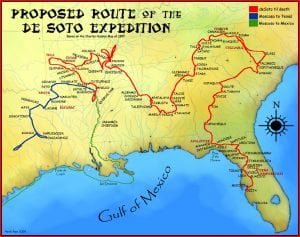
DeSoto Map

With seven ships of his own providing, and accompanied by from six hundred to one thousand warlike and energetic adventurers, many of whom were of noble rank, Hernando De Soto set sail, in the month of April, 1538. Upwards of a year was spent, mostly upon the island of Cuba, before the fleet set sail for the Florida coast. In the latter part of May, 1539, the vessels came to anchor off the bay of Espiritu Santo, now Tampa Bay, on the western sea-board, and a large division of soldiers, both horse and foot, were landed. The Indians had taken … Read more

The Shawnees

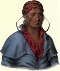
Payta Kootha

The Shawanees (Shawnees) were a very extensive and warlike tribe. They were, according to Indian tradition, originally from the south, having inhabited the country in the vicinity of Savannah, in Georgia, and a portion of West Florida. Being engaged in continual war with the Creeks and other southern nations, and being of an adventurous and roving disposition, they finally emigrated northward, and were received upon terms of friendship by the Delawares. They settled in Western Pennsylvania, extending themselves gradually farther west, and mingling with other neighboring nations. Their head-quarters were, in early times, not far from Pittsburgh. In their new … Read more

Biographical Sketch of William R. Jones

William R. Jones was born in the State of Georgia. His father’s name was John Jones, and the maiden name of his mother was Robinson. William R. came to Missouri in 1819, a single man, and settled in Montgomery County, where he was married the same year to Mary Whitesides, by whom he had John H., James H., Amanda, Mary M., Emeline, Nancy J., William R., Jr., Sylvesta M., Samuel A., Thomas S., and Perry S. All the children, except three, who are dead, live in Montgomery County. Mr. Jones was a Methodist preacher.

Biographical Sketch of John Hudson

John Hudson and his wife, who was a Miss Allen, lived in North Carolina. They had six sons Isaac, Drury, Thomas, William, John, and Jesse. Drury and Isaac were in the revolutionary war. The latter settled in Georgia, where he married Polly Shipper. He afterward removed to South Carolina, and from thence, to Kentucky, and in 1818 he came to Missouri. The names of his children were Elizabeth, Nancy, Sally, John, Thomas, William, and Charles. Elizabeth married Lemuel Cox. Nancy married Garrett Ingram. Sally married James Owings. John was married three times; first to Lucinda Morris, of Kentucky; second to … Read more

Troup County Georgia Genealogy

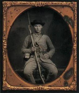
Civil War Soldier from Troup County GA

The land for Lee, Muscogee, Troup, Coweta, and Carroll counties was ceded by the Creek people in the 1825 Treaty of Indian Springs. Troup County was created June 9, 1825 and December 11, 1826 with 447 square miles acquired by Creek cessions of January 24, 1826 and March 31, 1826. It was named for George Michael Troup, 1780-1856. He was the governor of Georgia, 1823-1827. He was elected to the U.S. Senate. Later, he was nominated to be president of the United States. The court house burned in November 4, 1936 along with some records. The following is the information … Read more

Troup County Georgia Government Officials

Troup County Clerk of Superior Court 1827-1934 1827-34 N. Johnson 1835-42 Robert F. McGehee 1842-48 Moses Lee 1848-50 H. B. Williams 1850-62 William M. Latimer 1862-66 Inhn R Awtrev 1866-75 R. S. McFarlin 1875-81 John W. Sledge 1881-87 John Edward Toole 1887-96 E. T. Winn 1896-14 William L. Cleaveland 1914- G. Thomas Travlor Court of Ordinaries Roster 1852-1934 1852-56 Wiley H. Sims 1856-58 Thomas C. Evans 1858-64 Samuel Curtright 1864 James Turner 1864-68 Littleton Pitts 1868-72 Henry H. Cary 1873-77 Littleton Pitts 1877-88 William C. Yancey 1888-93 Robert M. Young 1893-01 John B. Strong 1901-25 Henry T. Woodyard 1925- J. … Read more

Mesoamerican Words in Itsate

Both Itsate and Muskogee have borrowed words from other languages. In fact, Muskogee is the most aberrant of all the Muskogean languages. Prior to the European Colonial Period the Muskogee speakers were a minority among the ancestors of the Creeks, but rose rapidly to power after the Itsate provinces were almost wiped out by plagues and slave raids. The original homeland of the Muskogee in the East was a triangle along the middle section of the Chattahoochee river, eastward to the area around Macon, GA. Muskogee seems to have been a blend of Itsate with a non-Muskogean language spoken along … Read more

The Native American Holocaust

The population of Mexico began to drop almost immediately after the arrival of the Spanish in 1519. A smallpox plague devastated the population of Tenochtitlan while it was under siege by the Spanish. Many other European diseases spread across Mexico and Central America in the years that followed.  Even prior to the Cortez Expedition, a smallpox plague devastated the Yucatan Peninsula, the Caribbean Islands and the advanced peoples living around the Mobile and Pensacola Bays on the Southeastern Gulf Coasts. Several European plagues that swept through Mexico during the 1500s and early 1600s killed anywhere from 30% to 80% of … Read more

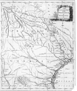
1779 Map of Georgia

1780 Georgia Map

The 1779 map of Georgia remains unattributed to a specific cartographer, but it has considerable similarities to a map published just one year later by Bew, called A new and accurate map of the chief parts of south Carolina and Georgia. Native American Research This map is important for Muskogee and Cherokee research as it details the locations of many Indian towns and Indian Trails. One can determine by looking at the Indian towns on the map that there was little known by this cartographer concerning the interior of Georgia from the Atlantic coast to the Flint River. While he … Read more

The Indigenous Peoples of Northern Georgia

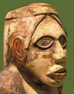
Etowah Woman

During the earliest part of this Paleo-Indians period, an ice sheet covered the portion of North America above the Ohio River. Brasstown Bald probably had a permanent ice cap, while permafrost characterized its upper elevations. No evidence of glaciers has been found. The valleys around Brasstown Bald would have been similar in appearance to those near the mountains of New England and Southern Quebec today. This Late Sub-Boreal Period evolved into an Isothermal Period in which northern and southern plant species grew in proximity. Vegetation grew throughout much of the year. This made possible the large mega-fauna populations. Around 10,000 … Read more

A Geospatial Analysis

Etowah 750 AD

As stated in Part Three, the Stratum Unlimited, LLC report in 2001 (Other Missing Stone Archaeological Sites) virtually ignored the Native American communities in northern Georgia. Almost all were contemporary with the occupation of the Track Rock Terraces. This omission was particularly inexcusable for the town sites that were adjacent to the two creeks, which flow off of Track Rock Gap, Town Creek and Arkaqua Creek.  In 1930s and 1940s, archaeologist George Wauchope found evidence of long term occupancy at these sites that apparently began before the Track Rock terraces were constructed, and sometimes continued into the Federal Period. It … Read more

Hernando de Soto Expedition to Georgia

The earliest recorded visit of Europeans to the Georgia and North Carolina Mountains was in 1540.  De Soto’s Conquistadors spent several summer weeks at the capital of Kvse (pronounced Kău-shĕ in Itsate-Creek, but known as Kusa in English.) Kvse means “forested mountains” in Itza Maya. Florida Indians told Pánfilo de Narváez in 1528 that the Apalachee People, who lived in the mountains many days to the north, mined and traded gold. The people, whom the Spanish called Apalache, called themselves the Palache, which is the Creek word for the Biloxi Indians. This is not general knowledge because the media has … Read more

Understanding the Obsession with All Things Cherokee

Many history buffs in the Georgia Mountains are obsessed with all things Cherokee. They assume that Creek place names such as Oconaluftee, Coosa, Oostanaula, Oothlooga, Etowah, Chattooga, Nottely, Yahoola, Enota, Tesnatee, Soque, Nacoochee, Tallulah, etc. are Cherokee words. The myths can all be traced to the presumptions made by the first white settlers to enter the region. That’s right . . . the main river on the North Carolina Cherokee Reservation is an Itsate Creek word meaning “Okonee People – isolated.”  The name has no meaning in Cherokee. The Okonee were major players in the mound-building business, who eventually joined … Read more

Discerning Facts and Myths About Track Rock Gap

In general, Loubser treated Cherokee legends as possible facts, while not discussing Creek Indian traditions whatsoever. Loubser first described two interpretations of the stone ruins that were provided to him by the staff of the Eastern Band of Cherokee’s Cultural Heritage Preservation Office.  Both interpreted the stone ruins as being burials. One version of this Cherokee legend is that the piles of stone at Track Rock Gap are the graves of great Cherokee warriors. There may be Cherokee burials at Track Rock Gap.  However, no stone burial cairns are associated with any known Cherokee village sites in North Carolina or … Read more

Interpretation of the Track Rock Gap Petroglyphs

As a major portion of its professional services to the U.S. Forest Service in the year 2000, Stratum Unlimited, LLC prepared graytone renderings of the six main boulders at Track Rock Gap. These renderings will be of incalculable value to the citizens of the United States in the future.  Because they remained exposed to the elements, the petroglyphs deteriorated at an accelerating pace in the early 21st century.  Acidic rainwater is the primary culprit.  The renderings of the Track Rock petroglyphs are presented on a website sponsored by the USFS. Johannes Loubser provided only generalized interpretation of the images on … Read more

Mysterious Fort Mountain, Georgia

When the Scottish, Ulster Scots and English settlers first arrived in eastern Tennessee and northwestern Georgia, they discovered a continuous chain composed of hundreds of fieldstone structures on the mountain and hill tops between Manchester, TN and Stone Mountain, GA. Some were merely piles of stones that archaeologists call cairns. Others formed small cylinders. Others were small rings. Still others were complex combinations of concentric rings with some perpendicular walls. At least two appeared to be walled villages. The Cherokees, who had moved into the region during the late 1700s, told the settlers that they didn’t build these structures. Some … Read more

Other Missing Stone Archaeological Sites

Inexplicably, Loubser did not mention a major field stone structure complex in Union County that can be seen from the acropolis of the Track Rock terraces in his Appraisal of a Piled Stone Feature Complex report.. This archaeological zone is known as Fort Mountain. It is not the same site as Fort Mountain State Park in Murray County, GA.  It is located at the edge of the Nottely River Valley in the Choestoe Community.  The two sites align on the azimuth of the Winter Solstice sunset.  The plaza of the acropolis is also aligned to this azimuth.  Draw a line from … Read more

Track Rock Gap Archaeological Survey

In the year 2000 the district office of the U. S. Forest Service in Gainesville, GA contracted with South African archaeologist Johannes Loubser to study the Track Rock Petroglyphs. Loubser operates under the professional name of Stratum Unlimited, LLC. Loubser’s published paper on the Track Rock survey was co-authored by Dr. Douglas Frink of Worcester State College in Massachusetts. This article is a brief analysis of that survey.