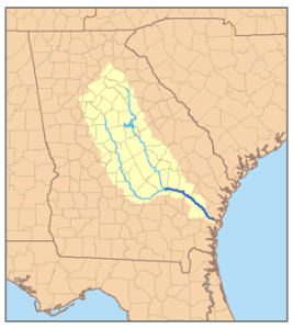
Along with the Oconee River, the Ocmulgee River is a major tributary of the Altamaha River System. Although little known outside of Georgia, the Altamaha is the third largest river on the Atlantic Coast. The Ocmulgee is 225 miles long from its beginning in the Georgia Piedmont to its confluence with the Oconee River in Southeast Georgia near Lumber City. The Altamaha continues another 140 miles to the coast at the old colonial port of Darien.
The largest tributaries of the Ocmulgee begin on the eastern edge of the Atlanta Metropolitan Area. They include the Alcovy, South and Yellow Rivers – all three of which are often flanked by swamps or seasonal wetlands. The location where the three rivers once joined is now under Lake Jackson.

Several other important tributaries join the river farther downstream. The Towaliga River flows southeastward from High Falls and joins the Ocmulgee just north of Juliette, GA. Rocky Creek is as large as many rivers in the state. It carries the water of Indian Springs via Big Sandy Creek to the Ocmulgee, south of Jackson, GA. Tobesofkee Creek joins the river just north of Macon. Echeconnee Creek forms the southwestern border of Bibb County and joins the river at the southern tip of Bibb. The Little Ocmulgee River flows out of Gum Creek Swamp and joins the Ocmulgee immediately east of Lumber City, GA and just upstream from the confluence of the Ocmulgee with the Oconee River.
Below Lake Jackson, the Ocmulgee drops at gentle slope of about 1 foot per mile. Between the wetlands that spawn the Ocmulgee’s tributaries in Metropolitan Atlanta and the Fall Line, the river flood plains are relatively narrow. These rivers flow in a generally straight pattern.
Below the Fall Line the Ocmulgee River slows, deepens and widens. The river’s bottomlands suddenly widen to between a half mile and several miles wide. The Ocmulgee then takes a serpentine path through the Coastal Plain. There is evidence of the river bed shifting many times in the past. The remnants of the old channels have created hundreds, if not thousands, of ponds, swamps, flood ways, deep creeks and terraces in the bottomlands.
Most of the streams entering the Ocmulgee below the Fall Line are navigable by a large canoe for at least a mile away from the river; some much further. Canoes could access the village from the small stream then be beached without concern for flooding.
During the thousands of years of Indian occupation, the navigability of Ocmulgee-Oconee-Altamaha River system enabled products of the Piedmont and Coast to be easily exchanged via large trade canoes. Flood-proof locations for villages were limited to islands in the wetlands and some terraces created by the tidal action of ancient oceans. Only timber pile structures were suitable elsewhere.
The Bond Swamp National Wildlife Refuge is a section of the enormous wetland region that parallels the Ocmulgee River south of the Fall Line in Macon. It is an ecological zone teeming with aquatic and animal life. The soil is extremely fertile as a result of repeated floods by the Ocmulgee River. It was essentially the “Garden of Eden” that spawned advanced Muskogean culture.
