A Mysterious Young Lady Named Liube

On one of the six main boulders of the Track Rock petroglyphs near Brasstown Bald Mountain, GA and across Track Rock Gap Road from the Track Rock Terrace Complex, a Jewish girl carved her first name, Liube, and the date, 1715.  The drawing of the petroglyphs was prepared by South African archaeologist, Johannes Loubser, as part of a contract with the U.S. Forest Service.  The six drawings are published on a public USFS web site. Liube is a Jewish female name that is mostly used in Slavic countries. It means “beloved” and in the past was a name that rabbis liked to … Read more

Site Tour of the Track Rock Gap Archaeological Zone

Track Rock Site Tour

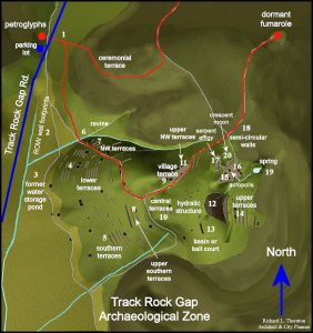
1 – Vent Trail: The entrance to the Vent Trail was only about 125 feet from Track Rock Gap Road.  The Vent Trail appeared to be an old logging road that varied from about eight to fourteen feet wide.  The trail’s lack of use had allowed dense stands of wild blackberries to grow up at the entrance along sections exposed to sunlight.  Since the trail leads to the dormant volcanic vent, it is also possible that centuries of foot and horse traffic have widened the original trail to the scale of a road. Until this point in time, we really … Read more

Understanding the Obsession with All Things Cherokee

Many history buffs in the Georgia Mountains are obsessed with all things Cherokee. They assume that Creek place names such as Oconaluftee, Coosa, Oostanaula, Oothlooga, Etowah, Chattooga, Nottely, Yahoola, Enota, Tesnatee, Soque, Nacoochee, Tallulah, etc. are Cherokee words. The myths can all be traced to the presumptions made by the first white settlers to enter the region. That’s right . . . the main river on the North Carolina Cherokee Reservation is an Itsate Creek word meaning “Okonee People – isolated.”  The name has no meaning in Cherokee. The Okonee were major players in the mound-building business, who eventually joined … Read more

Discerning Facts and Myths About Track Rock Gap

In general, Loubser treated Cherokee legends as possible facts, while not discussing Creek Indian traditions whatsoever. Loubser first described two interpretations of the stone ruins that were provided to him by the staff of the Eastern Band of Cherokee’s Cultural Heritage Preservation Office.  Both interpreted the stone ruins as being burials. One version of this Cherokee legend is that the piles of stone at Track Rock Gap are the graves of great Cherokee warriors. There may be Cherokee burials at Track Rock Gap.  However, no stone burial cairns are associated with any known Cherokee village sites in North Carolina or … Read more

Interpretation of the Track Rock Gap Petroglyphs

As a major portion of its professional services to the U.S. Forest Service in the year 2000, Stratum Unlimited, LLC prepared graytone renderings of the six main boulders at Track Rock Gap. These renderings will be of incalculable value to the citizens of the United States in the future.  Because they remained exposed to the elements, the petroglyphs deteriorated at an accelerating pace in the early 21st century.  Acidic rainwater is the primary culprit.  The renderings of the Track Rock petroglyphs are presented on a website sponsored by the USFS. Johannes Loubser provided only generalized interpretation of the images on … Read more

Other Missing Stone Archaeological Sites

Inexplicably, Loubser did not mention a major field stone structure complex in Union County that can be seen from the acropolis of the Track Rock terraces in his Appraisal of a Piled Stone Feature Complex report.. This archaeological zone is known as Fort Mountain. It is not the same site as Fort Mountain State Park in Murray County, GA.  It is located at the edge of the Nottely River Valley in the Choestoe Community.  The two sites align on the azimuth of the Winter Solstice sunset.  The plaza of the acropolis is also aligned to this azimuth.  Draw a line from … Read more

Track Rock Gap Archaeological Survey

In the year 2000 the district office of the U. S. Forest Service in Gainesville, GA contracted with South African archaeologist Johannes Loubser to study the Track Rock Petroglyphs. Loubser operates under the professional name of Stratum Unlimited, LLC. Loubser’s published paper on the Track Rock survey was co-authored by Dr. Douglas Frink of Worcester State College in Massachusetts. This article is a brief analysis of that survey.

The Track Rock Terrace Complex

In mid-July, a member of the Unicoi Turnpike Preservation Association,  telephoned me after reading an article that I had written in the Examiner. That particular column was about archaeological sites in western North Carolina.  He was also a member of the Towns County, GA Historical Society.  The Union County-Towns County line runs across the peak of Brasstown Bald Mountain, which contains Georgia’s highest elevation.  Brasstown Bald is immediately to the east of Track Rock Gap. The outdoor enthusiast was primarily interested in what I knew about the use of the Unicoi Turnpike during the Trail of Tears Period (1836-1838.)  The … Read more

Pre Darmos Casada

An inscription on a rock on Hoopers Bald contains the late Medieval Castillian words “PRE DARMOS CASADA – SEP 15, 1615” and an inscription on a boulder at Track Rock Gap contains the name “Liube 1725” a Jewish name… the significance of these inscriptions in South East United States are identified in this article.

The Trail to Yupaha

Track Rock Archaeological Site

An AccessGenealogy Exclusive: The Trail to Yupaha – Is Yupaha the Mayan connection to the Indians of the United States? This is a highly contentious look by Richard Thornton at the possibility of a trail he found in the Track Rock Gap area of Georgia being the connection to the Mayan of South America… The History Channel premiered it’s new show “American Unearthed” investigating this very issue. One of the people they interviewed on the show, now tells you in his own words, how this discovery all came about.