1851 Siler Roll: Eastern Cherokee

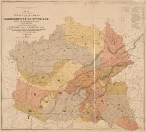
Map of Cherokee Land Cessions

The 1851 Siler Roll is a key genealogy resource for tracing Eastern Cherokee families who remained east of the Mississippi after the Trail of Tears. Compiled to identify those eligible for a federal per-capita payment, it lists households, family groupings, residences, ages, and relationships, but it is incomplete and should be used with the later Chapman Roll.
Understanding the Obsession with All Things Cherokee

In the Georgia Mountains, a fascination with Cherokee history persists, often leading to misconceptions about the region’s Native American heritage. Many place names attributed to the Cherokee actually derive from the Muskogean or Maya languages. The myth that Cherokees occupied northern Georgia until 1838 is rooted in early settler assumptions and has misled even archaeologists. Historically, the Cherokees had a minimal presence in the region before the American Revolution, primarily as hunters, and they faced significant political pressure from Georgia for their removal to Oklahoma.

Discerning Facts and Myths About Track Rock Gap

The Nacoochee Valley hosts a mound and town above ancient stone box graves, with Cherokee legends attributing these stone structures to burials of warriors. However, no known Cherokee burial sites exist in the region. Claims of the Cherokees conquering Georgia are historically inaccurate, as they suffered defeats in the Creek-Cherokee War. Legends, including those relayed by the Swimmer to ethnologist James Mooney, are criticized as embellishments. Additionally, European maps reveal that the territory was predominantly occupied by the Apalachee and Creek Indians, challenging the narrative of Cherokee dominance.

Interpretation of the Track Rock Gap Petroglyphs

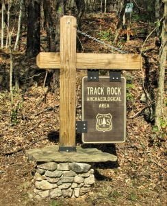
The Track Rock petroglyphs, recently preserved by the USFS, feature ancient carvings that have deteriorated due to environmental exposure. Renderings created in 2000 by Stratum Unlimited, LLC document these boulders and their intricate designs. Interpretations suggest multiple ethnic groups contributed to the petroglyphs over time, with some images linked to the Creek Indians and Itza Maya glyphs. The predominant themes in these carvings reflect significant cultural symbols rather than mere graffiti, as argued against prior interpretations attributing them solely to Cherokee hunters.

Track Rock Gap Archaeological Survey

In 2000, the U.S. Forest Service commissioned South African archaeologist Johannes Loubser to survey the Track Rock Petroglyphs, aided by local groups and the Eastern Band of Cherokee Indians. The survey involved two test pits and comprehensive soil analysis, revealing no evidence of Spanish colonial structures. Loubser’s published findings sparked further investigation, leading to a more accurate site plan created by a local historian, which uncovered additional features not included in Loubser’s report. The survey highlighted the complexity of the Track Rock Gap archaeological zone.

The Track Rock Terrace Complex

Recent communication with a local historian revealed significant archaeological findings near Track Rock Gap. The area features stone walls and piles, with recent studies indicating a complex dating back over a thousand years. Analysis by archaeologist Johannes Loubser suggests the presence of a terrace complex, with pottery evidence suggesting origins as early as 750 AD. This challenges previous assumptions regarding the site’s history, particularly the notion of it being a Sephardic mining village established in the 1600s. The impact of acid rain has diminished the visibility of nearby petroglyphs.

Pre Darmos Casada

The author’s initial interest in an archaeological zone in Union County, Georgia, arose from discovering features they believed were linked to gold mining. This investigation led to findings of old fieldstone foundations, which they hoped could be remnants of 17th-century Spanish Sephardic colonists. A significant discovery was an inscription on a boulder, later identified as a memorial to a Sephardic marriage in 1615. The author posits that the ruins signify an early Jewish village, supported by additional inscriptions suggesting a Jewish presence in the area.

The Trail to Yupaha

Track Rock Archaeological Site

On June 21, 2011, the author celebrated the Summer Solstice with a hike in the Georgia Mountains, near the Nantahala River, alongside three dogs. He revisited the Track Rock petroglyphs, noticing their deterioration since his last visit. His exploration revealed ancient fieldstone walls and historical alterations to the landscape, prompting inquiries into the area’s archaeological significance. This led to a deeper investigation into the cultural history of Georgia’s Indigenous Peoples, particularly regarding the enigmatic Track Rock Terrace Complex and its connection to Cherokee and Creek legends.

Biographical Sketch of John F. Thompson

John Franklin Thompson, born on November 20, 1853, in Union County, Georgia, was the son of Caleb Starr and Matilda Thompson. He married Amanda C. Little in 1876, and they had several children, including Lewis, David, and John Nelson. A farmer near Tahlequah, Thompson was active in the community, joining Cherokee Lodge No. 10 in 1883 and serving as Master from 1896 to 1900. He was also elected County Commissioner of Cherokee County in November 1916.

Native American History of Union County, Georgia

Union County, Georgia, situated in the Blue Ridge Mountains, boasts a rich Native American history, with evidence of habitation dating back at least 12,000 years. Significant archaeological sites reflect various cultural phases, including the Woodland, Swift Creek, and Cherokee periods, marked by advanced agricultural practices and trade routes. Despite its isolation until the mid-20th century, Union County’s Native heritage has often been overshadowed by tourism focused on outdoor recreation. The legacy of early inhabitants remains integral to understanding the region’s historical narrative.

Henderson Roll: 1835 Cherokee East of the Mississippi Census

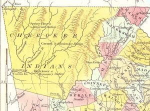
1830 Map of Cherokee Territory in Georgia

An extract from the 1835 Cherokee East of the Mississippi Census, also known as the Henderson Roll, this database lists Cherokee households remaining east of the Mississippi before removal. It includes heads of households, family members, enslaved people, and whites connected by marriage, along with residence. The roll was later used in Cherokee ancestry claims.