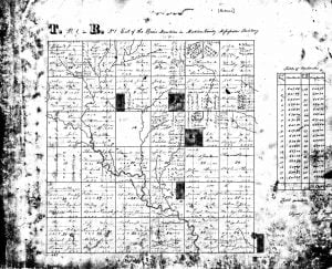
These township plat maps began with the Public Lands Survey in the United States initiated by the Land Ordinance Act of 1785, and this collection includes maps for all or parts of Alabama, Illinois, Indiana, Iowa, Kansas, Mississippi, Missouri, Ohio, Oklahoma, Oregon, Washington, and Wisconsin. Maps were prepared from survey field notes taken by deputy surveyors and can include physical details and man-made improvements. They also indicate township and section lines, section numbers, acreage of holdings, and sometimes names of landholders.
Original Description
This microfilm reproduces original manuscript plats of townships in Alabama, Illinois, Indiana, Iowa, Kansas, Mississippi, Missouri, Oklahoma, Wisconsin, and parts of Ohio, Oregon, and Washington that were surveyed by deputy surveyors under the direction of surveyor generals of the General Land Office (GLO), now called the Bureau of Land Management (BLM). They represent the earliest township and range public land surveys in the United States, beginning with the survey of the Seven Ranges in Ohio, 1785-87. Custody of the plats from these States and parts of States has been transferred to the National Archives. The plats are filed among the records of the Bureau of Land Management, Record Group 49. The BLM has retained custody of most of the manuscript plats and survey field notes of the remaining public domain States. Information about plats in the custody of the BLM can be obtained from:
Eastern States Office, Bureau of Land Management
20 M Street SE, Suite 950
Washington, DC 20003
Bureau of Land Management
1849 C Street NW, Rm. 5665
Washington DC 20240

Three identical manuscript plats were prepared from the survey field notes for each township. One was approved by the surveyor general of a given district and eventually turned over to the appropriate Territory or State. Many of these plats are maintained by State archives today. One plat was sent to the GLO headquarters in Washington, D.C. where it was added to the “headquarters” master set. The remaining plat was retained by the local LO land office having jurisdiction over the township for use in recording the initial disposition of the public lands. When local land offices were closed, these plats were sent to Washington and added to. the “local office” plat set. The headquarters and local office plats from Illinois, Indiana, Iowa, Kansas, Missouri, and parts of Ohio, as well as the local office plats for Alabama, Mississippi, Oklahoma, Wisconsin, and parts of Oregon and Washington eventually came to the National Archives and formed the basis of this microfilm. The headquarters and local office plats have been merged into one continuous series arranged alphabetically by State for ease of reference.
Each plat covers all or part of one township (composed of 36 sections of one square mile or 640 acres each). There are often several plats for a given township, including the local office and the headquarters plats, resurvey plats of a later date, fractional plats covering parts of townships surveyed at different dates, and fractional plats from resurveys where a discrepancy may have occurred in the original survey.
In addition to showing the township and section lines, many of these plats also show drainage, roads and trails, Indian villages, boundaries of private land claims and grants, boundaries of Indian cessions and reservations, sections reserved for schools or other use, cultivated fields, swamp-lands, and forested areas. Acreage is indicated for fractional sections. Descriptive information about the soils and corner section posts is sometimes given on the reverse of the plats. Most of the plats formerly maintained in the local land offices-bear annotations that show land entry numbers referring to the original sale or disposition of each parcel of land to the first landholders or entry-men. In a few instances the names of the original landholders or entry-men also appear on the plats.
Related records in the National Archives include volumes of survey field notes used to prepare the headquarters plats for Illinois, Indiana, Iowa, Kansas, Missouri, and parts of Ohio; and land entry papers and tract-books that correspond to the land entry numbers shown on the local office plats (see National Archives Preliminary Inventory No. 22, Preliminary Inventory of the Land-Entry Papers of the General Land Office, Washington, 1949.
The plats are arranged alphabetically by name of State, and there-under, with the exception of plats of Ohio, by the governing principal meridian, then by range number, followed by township number. Plats of Ohio remain in their original bound volumes and can be located by referring to an index map.
Order of Arrangement:
- State (alphabetical order)
- Principal Meridian (numerical order, or roughly from north to south if named. “1 PM” refers to the First Principal Meridian).
- Geographic quadrant of each meridian (northeast, northwest, southeast, and southwest, with gaps as appropriate for a given State).
- Range number
- Township number
Online Locations
These early land ownership and township plats can be found online only at the following location:
Further Reading
- Preliminary Inventory of the Land-Entry Papers of the General Land Office
Preliminary Inventory of the Land-Entry Papers of the General Land Office. Compiled by Harry P. Yoshpe and Philip P. Brower. Preliminary Inventory No. 22. (Washington, The National Archives, 1949, pp. 77) The inventory includes military-bounty-land warrants and related papers, entries arranged by State and Name of district land offices, and patented cases subsequent to 1908. Appendix I lists the land laws under which most entries have been made and Appendix II gives an alphabetical listing of land offices. - Research in the Land Entry Files of the General Land Office
Research in the Land Entry Files of the General Land Office. Compiled by Kenneth Hawkins. Reference Information Paper 114. (Washington, The National Archives, 2009, pp. 22) . This manuscript replaced General Information Leaflet, Number 67.
