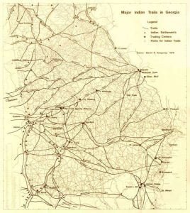
A correct and detailed knowledge of the Indian trails leading through their country, and called by them warpaths, horse trails, and by the white traders “trading roads,” forms an important part of Indian topography and history. Their general direction is determined by mountain ranges and gaps (passes), valleys, springs, watercourses, fordable places in rivers, etc. The early explorers of North American countries all followed these Indian trails: Narvaez, Hernando de Soto, Tristan de Luna, Juan del Pardo, Lederer and Lawson, because they were led along these tracks by their Indian guides. If we knew with accuracy the old Indian paths of the West, we would have little difficulty in rediscovering the routes traveled by Coronados and Peñalossas troops in New Mexico and in the great wastes of the Mississippi plains. In hilly lands these trails are, of course, easier to trace than in level portions of the country.
The best-known trails leading from the east to the Creek towns were as follows:
- The upper trail or “warpath” crossed Chatahuchi River at Cheláko-Nini by a horse ford, about sixty miles above Kasiχta; cf. Schoolcraft, Indians, V, 255, and Adair, History, pp. 258, 368.
- The “High Tower path” started from High Shoals on Apalachi river, which is the southern branch of Okóni River, and went almost due west to “Shallow Ford” of Chatahuchi River, about twelve miles right north of Atlanta, Georgia, in the river bend.
- The southern trail crossed the Chatahuchi River, coming from the Okoni and Okmulgi Rivers, 1 at the “Broken Arrow,” Lé-kátchka, while other travelers crossed it at the Yuchi towns, which cannot have been distant from the “Broken Arrow. The Tallapoosa River was passed at Tukabatchi; cf. Schoolcraft, Indians, V, 254. From Tukabatchi it crossed over almost due west, as represented in Em. Bowens map, to Coosa River, which was passed by a horse-ford, then followed the Coosa River up to Coosa old town. This is the trail partly traveled over by the Kasiχta tribe, as described in the migration legend.
- The trail leading from St. Marys River, Georgia, to the Creek towns went into disuse since 1783, and at the time of Swans visit (1791) was difficult to trace. Cf. Schoolcraft, V, 256. If correctly represented in Tanners map of 1827, a road then running from St. Marys River to the Hitchiti ford of the Chatahuchi River crossed that river at Hitchit-ú-dshi.
Citations:
- Bartram, Travels, p. 54, gives the following particulars: “On the east bank of the Okmulgee this trading road runs nearly two miles through ancient Indian fields, the Okmulgee fields . . . with artificial mounds or terraces, squares, etc.” This horse path began at the Rock Landing on Okoni River, a British post just below Wilkinson and about four miles below Milledgeville, Georgia, passed Fort Hawkins built upon the Okmulgi old fields, then the site of Macon, on the shore opposite, then Knoxville, then the old Creek agency on Flint river, then crossed Padshiläika creek, the usual ford on Chatahuchi river lying between Kasiχta and Apatá-i Creek.[↩]
