
Old Indian Trails of Pike’s Peak

The principal Indian trail into the Pikes Peak area originated from the plains via Templetons Gap, crossing significant points like Monument Creek and the Garden of the Gods. This route, known as the Ute Pass trail, was utilized by various tribes for centuries. Notable historical figures such as Dr. Edwin James and Thomas J. Farnham documented this trail’s importance for trade and travel. The region saw frequent conflicts among tribes, especially between the Ute and the Cheyenne and Arapaho, until the arrival of white settlers in the mid-19th century.
Manitou Springs

Dr. Edwin James, botanist and historian, described Manitou Springs in 1820 as a notable site with a large, aerated boiling spring known for its sparkling, refreshing water. This spring, held in reverence by indigenous peoples, was often used for offerings. Accounts from visitors like Rufus Sage and Lieut. John C. Fremont in the 1840s further underscore its significance, noting the spring’s effervescence and sacred status among the Arapaho, who believed it was imbued with spiritual power. The surrounding scenery boasts rich vegetation and diverse wildlife, contributing to the area’s allure.

Iroquois Trails in Pennsylvania

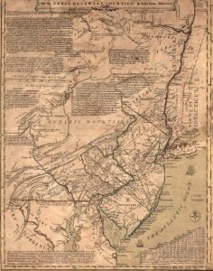
1749 Lewis Evans Map

The 1749 Lewis Evans Map illustrates several significant Iroquois Trails in Pennsylvania, highlighting the routes of the Mohawk warriors as they journeyed along the Susquehanna River. They visited historical sites associated with Oneida chief Shikellamy, traversed notable paths like the Sheshequin Path to important council locations such as Tioga Point, and encountered villages like Mingo Town, which restricted white passage. The trails served as critical links between Iroquois territory and regions beyond, facilitating both trade and diplomacy in early America.

Trade Routes in the Lower Southeast

The Great White Path, an essential trade route for the Creek Indians, ran through Track Rock Gap and connected significant towns. French explorer René Goulaine de Laudonniére noted that trade in the late 1500s predominantly flowed north-south, exchanging valuable resources from the Southern Highlands for goods from lower altitudes. While Track Rock Gap was important, other routes through the Appalachian Valley and Savannah River Basin were even more crucial for trade. The pathway began near Etowah Mounds, extending towards the Blue Ridge Mountains and the Smoky Mountains.

The Creek Indian Trails

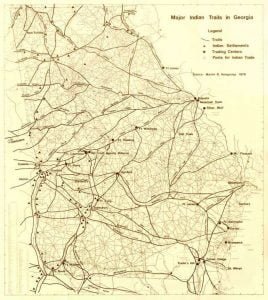
Georgia Indian Trails and Early Roads

The Indian trails in Georgia, known as warpaths and trading roads, were crucial for navigating the land and played a significant role in early exploration. These routes were guided by natural features such as rivers and valleys and were utilized by explorers like de Soto and others. Notable trails included the upper trail crossing the Chatahuchi River and the High Tower path from Apalachi River. The southeastern trail connected St. Mary’s River to Creek towns but fell into disuse after 1783, becoming difficult to trace by 1791.

The Great Central Trail Of The Long House, Route 5, New York

The Iroquois Indians, adept woodsmen, established the foundational trails used by early settlers in New York. These paths, honed over centuries, facilitated land and water travel, eventually influencing modern railroads and highways. Important routes include the Connecticut Path and the Kittanning Path, which have evolved into major thoroughfares. The Iroquois trails interconnected their villages, leading to present-day cities such as Buffalo and Syracuse. Historical markers along Route 5 highlight these ancient trails, reflecting their significance in the region’s development.