Missouri Atlases and Plat Books

Sample Missouri Plat Book closeup

198 online plat books and atlases organized by county and ordered by date for the State of Missouri. At the bottom of the page are two items that can help you use these documents in your genealogy research. The first is a blog post Plat Books Revealed: Mapping Generations of History and the second a video where Ben Clark explains what plat maps are used for, how to navigate them, and pulls out a few interesting stories from them.

Iowa Atlases, Farm Directories, and Plat Books

1859 Map of Washington County Iowa

This collection contains digital atlases, farm directories, and plat books for all 99 Iowa counties. We have collated these from a variety of online sources, and provide them here as a single source for all online Iowa County Atlases, Farm Directories, and Plat Books.

How the Government Surveys Land

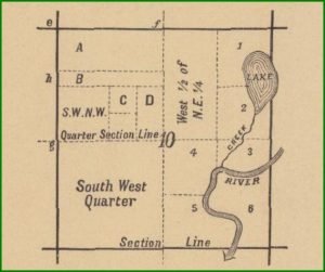
Example of a Quarter Section in a Plat Map

From instructions by J. A. Williamson, Commissioner The rectangular system of surveying Government lands, termed the Land System of the United States, was adopted by an act of Congress passed May 20, 1785. The ordinance provided for townships six miles square, containing thirty-six sections of one mile square. The region embraced by the surveys under this law forms a part of the present State of Ohio, and is usually styled “Old Seven Ranges.” The town-ships, six miles square, were laid out in ranges, extending northward from the Ohio River, the townships being numbered from south to north, and the ranges … Read more