The Native American History of Florida’s Lake Okeechobee Basin
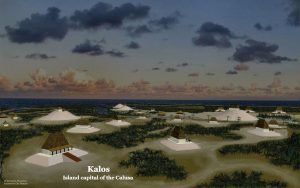
The Lake Okeechobee region contained some of the most sophisticated indigenous cultures that ever existed north of Mexico. Its towns built large earthworks and ponds in the shape of the ceremonial scepters carried by leaders in the Southeastern Ceremonial Mound Culture, but they were built several centuries before the Southeastern Ceremonial Mound Culture appeared elsewhere. Its engineers constructed several hundred miles of canals and raised causeways to interconnect the towns. They even built locks to enable cargo canoes to bypass rapids. Yet despite all this cultural precociousness, so far there is no evidence that the people of South Florida ever practiced large scale agriculture. However, intensive cultivation of raised garden beds in a semi-tropical climate, also a practice of the Mayas, may have produced a far higher percentage of their diet than anthropologists currently presume.


