The Starting Point of the Expedition on Lake Ontario

The narrative states that the expedition descended what is now known as Trent River, which empties into Lake Ontario, and after short days’ journeys, reached the border of Lake Ontario. It then proceeds. I give the original French, as Champlain’s works are quite rare, and copy from the edition of 1619, modernizing the old French orthography: “où etans, nous fimes la traverse en l’un des bouts, tirant a. l’orient, qui est l’entrée de la grande rivière St. Laurens, par la hauteur de quarante-trois degrés de latitude, où it y a de belles iles fort grandes en ce passage.” Where then … Read more

The Route Across the Lake

If I am right in fixing the starting point opposite Point Pleasant, it would follow, both from the text and the map, that the route extended southerly, between that point and Amherst Island, to the False Ducks, and along the Main Duck, Gallo, and Stony Islands, which stretch across the lake in the direction of Stony Point. That this was the course pursued may be inferred from the following considerations: First. On examining the Champlain map, the line indicating the route starts from the northern shore of the lake, and passes directly south between Point Pleasant and the first island … Read more

The March on the Beach

Champlain says: ” Les sauvages cachèrent tous leurs canaux dans les bois, proche du rivage. Nous fimes par terre quelques quatre lieuës sur une plage de sable, ou je remarquai un pays fort agreable et beau, traversé de plusieurs petits ruisseaux, et deux petites rivières, qui se dechargent au susdit lac, et force etangs et prairies.” ” The Indians concealed all their canoes in the woods near the shore. We proceeded by land about four leagues over a sandy beach, where I observed a very agreeable and beautiful country, intersected by many small brooks and two small rivers which empty … Read more

The Location of the Fort Ticonderoga

It is utterly impossible, from the Champlain text and map, aided by the best modern charts, and an accurate knowledge of the country, to establish, with any certainty, the exact position of the Iroquois fort. The location which I suggested was on or near Onondaga Lake, 4 leagues or 10 miles from the great Iroquois fishery at the foot of Oneida Lake. The limits of this article forbid my presenting at this time my reasons for this conclusion I will therefore confine myself to an examination of General Clark’s position. He locates the fort on Nichols Pond, in the north-east … Read more

The Landing on the South Shore

I suggested in my article that the expedition probably landed in the secluded cove now known as Henderson Bay, sheltered by Stony Point. Not that the text or map of Champlain indicates that, or any other particular place with any certainty, but First. Because it appeared a convenient and appropriate locality. It did not seem probable that Champlain, accompanied by so large an army, would boldly land on an enemy’s shore, exposed to observation for twenty miles in two directions, with scarcely a hope of successfully concealing the canoes, which were so essential for his return voyage. Second. Because Henderson … Read more

The Inland Route to the Fort Ticonderoga

My reasons in favor of the mouth of the Salmon River as the point of departure for the interior are as follows: First. It is the southernmost and last point on the lake in the direct line of travel between Stony Point and the foot of Oneida Lake. The mouth of Salmon Creek lies west of that line, requiring a detour that would increase the travel without affording any corresponding advantage. Second. The mouth of Salmon River-the Otihatangué of the early French maps -has always been a noted place in Indian history. It is mentioned on the oldest Ms. maps … Read more

The Authenticity and Accuracy of Champlain’s 1632 Map

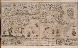
1612 Map of New France

In order to account for the many manifest discrepancies between Champlain’s text of 1619 and the map annexed to the edition of 1632, I suggested that the map and the latter edition were not the work of Champlain and never passed under his personal supervision. I gave my reasons for this opinion on pages 5 and 6, vol. I, of this magazine. Dr. Shea replies to this, ” the map is evidently Champlain’s, and he was too good a hydrographer for us to reject his map as a guide for parts he actually visited.” This, however, is assuming the authenticity … Read more

Reply to Dr. Shea and General Clark

The first number of this magazine (Jan., 1877) contains an article on the Expedition of Champlain against the Onondagas, in 1615. It was founded on a communication read before the New York Historical Society in March 1849, in which I had discussed the evidences, which exist as to the route of the expedition, and the site of the Iroquois fort, which it besieged. My position having been questioned by several eminent historians, who claimed a more western location for the fort, the main object of my last article was to fortify my former conclusions. In it I endeavored to trace … Read more

Jesuit Doblon’s traveled the Route Twice

It may be interesting, in this connection, to compare Champlain’s statements with those of the Jesuit Dablon, who traveled twice over the same route in 1655 and 1656, under much more favorable circumstances for correctly estimating the distances. He informs us that, in company with Father Chaumonot, he left Montreal on the 7th day of October, 1655, for the Onondaga country, and reached ” Otihatangue” (the mouth of Salmon river) by canoe on the 29th of the same month. That he landed the next day, and prepared to go on foot to Onondaga. That on the first day of November, … Read more

Champlain’s Expedition of 1615 Against the Onondaga

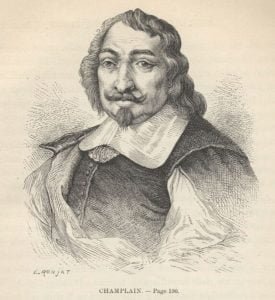
Samuel de Champlain, by E. Ronjat

In the year 1615, there dwelt on the south-eastern shore of Lake Huron, between Lake Simcoe and the Georgian Bay, a nation of Indians who were called in their own language, “Wendats” or “Wyandot,” and by the French ” Huron.” There is no record of their having been visited by the white man prior to the above date. In the same year, the Sieur de Champlain, the Father of French Colonization in America, who had entered the St. Lawrence in 1603 and founded Quebec five years later, ascended the river Ottawa as far as the Huron country-Le Caron, the Franciscan, having preceded him by a few days only. These adventurous pioneers were seeking, in their respective spheres, and by concurrent enterprises, the one to explore the western portions of New France, and the other to establish missions among the North American Indians.