The ancient habitat of the Arapaho, according to tradition, was once far northeast of the country which they later occupied. It may have been among the forests of the region about the headwaters of the Mississippi the present State of Minnesota, where their villages would have stood on the shores of lakes and streams. But later, like the related Cheyenne, with whom they have been closely allied during recent generations and probably for a long period, they reached the prairies, through what causes may never be known, and there, with different environments, their manners and ways of life changed. While a people of the timbered country, they undoubtedly reared and occupied the forms of habitations so characteristic of the forests, as exemplified by the wigwams of the Ojibway and other tribes in recent times, but after reaching the prairie country, where buffalo were obtained in such vast numbers, their villages or camps assumed the appearance of those of the Siouan tribes, conical skin lodges taking the place of the mat or bark covered structures.
The Atsina, a detached division of the Arapaho, closely associated with the Blackfeet, were often mentioned by the early writers as the Gros Ventres of the Prairie, and in certain English narratives as the Fall or Rapid Indians. In other journals they were mentioned under the name Minnetaree of Fort de Prairie. Thus they were called by the early American explorers.
On May 29, 1805, just two weeks before arriving at the Great Falls of the Missouri, the Lewis and Clark party reached Judith River, and a short distance above its junction with the Missouri “We saw the fires of one hundred and twenty-six lodges, which appeared to have been deserted about twelve or fifteen days, and on the other side of the Missouri a large encampment, apparently made by the same nation. On examining some moccasins which we found there, our Indian women said that they did not belong to her own nation the Snake Indians, but she thought that they indicated a tribe on this side of the Rocky mountains, and to the north of the Missouri; indeed it is probable that these are the Minnetaree of fort de Prairie.” 1 The following year, when the expedition was returning from the west, the tribe was again mentioned. On July 15, 1806, the expedition passed Shields River, and two days later reached Brattons River (now Bridger Creek), a tributary of the Yellowstone in the present Sweetgrass County, Montana. Here, “In one of the low bottoms of the river was an Indian fort, which seems to have been built during the last summer. It was built in the form of a circle, about fifty feet in diameter, five feet high. and formed of logs, lapping over each other, and covered on the outside with bark set up on end, the entrance also was guarded by a work on each side of it, facing the river. These entrenchments, the squaw informs us, are frequently made by the Minnetaree and other Indians at war with the Shoshonee, when pursued by their enemies on horseback.” Another similar work was encountered the next day. 2
The preceding references to fortified camps are of great interest, but similar works were mentioned by other explorers of the upper Missouri Valley. During the summer of 1833 several were encountered by Maximilian, and on July 18 of that year he wrote: ” On this day at noon, we reached, on the south bank, an Indian fort, it is a kind of breastwork, which Indian war-parties construct in haste of dry trunks of trees. This fort consisted of a fence, and several angles, enclosing a rather small space, with the open side towards the river. In the, center of the space there was a conical hut, composed of wood. Near this fort, on the same bank of the river, there was a beaver’s den made of a heap of brushwood.” 3 Six days before, on July 12, they had encountered several huts probably similar to that which stood within the “fort.” In the narrative it is said: “Just at the place where our vessel lay, were four old Indian huts, of some war or hunting party, composed of trunks and boughs of trees piled together in a square, in which some of our party made a fire to cook their meat. Scarcely 100 paces above these huts, was the Indian Fort Creek of Lewis and Clark.” 4
Elsewhere in this sketch other native “forts” will be mentioned. The erection of such works appears to have been quite common among the widely scattered tribes.

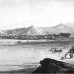
Fortunately, a very interesting picture of a skin lodge village or camp of the Atsina has been preserved, a painting made by Bodmer during the summer of 1833, when it was visited by Maximilian. It stood on the bank of the Yellowstone, at the mouth of the Big Horn, near the dividing line between Rosebud and Yellowstone Counties, Montana. Describing the settlement as it appeared on the evening of August 3, 1833, Maximilian wrote: “On the left was the mouth of Bighorn River, between considerable hills, on which numbers of Indians had collected. In the front of the eminence the prairie declined gently towards the river, where above 260 leather tents of the Indians were set up; the tent of the principal chief was in the foreground, and, near it, a high pole, with the American flag. The whole prairie was covered with Indians, in various groups, and with a numerous dogs; horses of every color were grazing round, and horsemen galloping backwards and forwards, among whom was a celebrated chief, who made a good figure on his light bay horse.” These were the Gros Ventres, “called by the English, Fall Indians.” 5 Bodmer’s painting, or more correctly, an engraving made from the painting, is reproduced in plate 17.
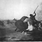
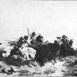
On July 8, 1842, Fremont, while on his journey to the Rocky Mountains, reached a village of the Arapaho and Cheyenne. But before arriving at the village the party came in contact with a large number of Indians belonging to the two tribes, who were chasing a herd of buffalo. Of the exciting scene presented by these many mounted Indians and the rushing buffalo, he left a vivid account: ” We were too far’ to hear the report of the guns, or any sound; and at every instant, through the clouds of dust, which the sun made luminous, we could see for a moment two or three buffalo (lashing along, and close behind them an Indian with his long spear, or other weapon, and instantly again they disappeared. The apparent silence, and the dimly seen figures flitting by with such rapidity, gave it a kind of dreamy effect, and seemed more like a picture than a scene of real life. It had been a large herd when the cerne commenced, probably three or four hundred in number; but, though I watched them closely, I did not see one emerge from the fatal cloud where the work of destruction was going on. After remaining here about an hour, we resumed our journey in the direction of the village.

“Gradually, as we rode on, Indian after Indian came dropping along, laden with meat; and by the time we had neared the lodges, the backward road was covered with the returning horsemen. It was a pleasant contrast with the desert road we had been traveling. Several had joined company with us, and one of the chiefs invited us to his lodge. The village consisted of about one hundred and twenty-five lodges, of which twenty were Cheyenne; the latter pitched a little apart from the Arapahoe. They were disposed in a scattering manner on both sides of a broad, irregular street, about one hundred and fifty feet wide, and running along the river. As we rode along, I remarked near some of the lodges a kind of tripod frame, formed of three slender poles of birch, scraped very clean, to which were affixed the shield and spear, with some other weapons of a chief. All were scrupulously clean, the spear-head was burnished bright, and the shield white and stainless. It reminded me of the days of feudal chivalry; and when, as I rode by, I yielded to the passing impulse, and touched one of the spotless shields with the muzzle of my gun, I almost expected a grim warrior to start from the lodge and resent my challenge. The master of the lodge spread out a robe for me to sit upon, and the squaws set before us a large wooden dish of buffalo meat. He had lit his pipe in the mean while; and when it had been passed around we commenced our dinner while he continued to smoke. Gradually. five or six other chiefs came in, and took their seats in silence. When we had finished, our host asked a number of questions. A storm had been gathering for the past hour, and some pattering drops on the lodge warned us that we had some miles to our camp. We found our companions under some densely foliaged old trees. about three miles up the river. Nearly opposite was the mouth of one of the most considerable ailments of the South fork, la Fourche aux Castors, (Beaver fork,) heading off in the ridge to the southeast.” 6 This would have been near the eastern boundary of the present Morgan County, Colorado, a region approaching the western edge of the great prairie, in the midst of the range of vast herds of buffalo. The entire description of the events of the day as prepared by Fremont reads more like fiction than fact and is one of the clearest and most concise accounts extant of a buffalo hunt by native tribes under such conditions. The paintings by Stanley and Wimar, as reproduced in plates 2 and 3, would serve to illustrate Fremont’s narrative.

The following year (1843) Fremont, on his second expedition, reached St. Vrain’s Fort; thence continuing up the South Fork of the Platte he soon arrived in the vicinity of the present city of Denver, and at some point not far below the mouth of Cherry Creek discovered a large Arapaho village. This was on July 7, 1843, and to quote from his journal: “We made this morning an early start, continuing to travel up the Platte; and in a few miles frequent bands of horses and mules, scattered for several miles round about, indicated our approach to the Arapaho village, which we found encamped in a beautiful bottom, and consisting of about 160 lodges. It appeared extremely populous, with a great number of children; a circumstance which indicated a regular supply of the means of subsistence. The chiefs, who were gathered together at the farther end of the village, received us (as probably strangers are always received to whom they desire to show respect or regard) by throwing their arms around our necks and embracing us.
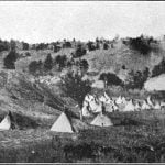
A photograph of a small Arapaho village, standing in Whitewood Canyon, Wyoming, about the year 1870, is reproduced in plate 16b. The skin-covered lodges shown in this photograph were probably similar to those sketched by Bodmer a generation before.
Citations:
- Lewis and Clark, History of the Expedition under the command of Captains Lewis and Clark. . . Prepared for the press by Paul Allen. Philadelphia, 1814. 2 vols, I, p. 234.[↩]
- Lewis and Clark. History of the Expedition under the command of Captains Lewis and Clark. . . Prepared for the press by Paul Allen. Philadelphia, 1814. 2 vols., II, pp. 379-380.[↩]
- Maximilian, Prince Of Wied, Travels in the Interior of North America. London, 1843, p. 216.[↩]
- Maximilian, Prince Of Wied, Travels in the Interior of North America. London, 1843, p. 212.[↩]
- Maximilian, Prince Of Wied, Travels in the Interior of North America. London, 1843, pp. 231-232.[↩]
- Fremont, J. C., Report of the Exploring Expedition to the Rocky Mountains in the year 1842, and to Oregon and North California in the years 1843-44. Washington, 1845, pp. 29-30.[↩]
- Fremont, J. C., Report of the Exploring Expedition to the Rocky Mountains in the year 1842, and to Oregon and North California in the years 1843-44. Washington, 1845, pp. 111-112.[↩]
