Ancient Entrenchments on Fort Hill, near Le Roy, Genesee County

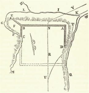
Sketch of the Ancient entrenchments on Fort Hill, near Le Roy, Genesee County

The following diagram of this work has been drawn from a pen-sketch, forwarded by the Rev. Mr. Dewey, of Rochester. The work occurs on an elevated point of land formed by the junction of a small stream, called Fordham’s Brook, with Allen’s Creek, a tributary of the Genesee River. Its position is about three miles north of the village of Le Roy, and some ten or twelve northeast of Batavia. The best view of the hill, as one of the natural features of the country, is obtained a short distance north of it, on the road from Bergen to Le … Read more

A Sketch of the Iroquois Groups of Aboriginal Tribes

On the discovery of North America, the Iroquois tribes, were found seated chiefly in the wide and fertile territory of western and northern New York, reaching west to the sources of the Ohio; north, to the banks of Lake Champlain and the St. Lawrence; and east, to the site of Albany. They had as much nationality of character, then, as any of the populous tribes, who, in the 4th century wandered over central and western Europe. They were, in a high degree, warlike, handling the bow and arrow with the skill and dexterity of the ancient Thracians and Parthians. They … Read more

American Antiquities

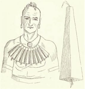
Medaeka Missouric. See Fig. 1, Plate V

Class First. Nabikoáguna. Objects of this kind were worn as marks of honor or rank. So far as known, they were constructed from the most solid and massy parts of the larger seashells. Few instances of their having been made from other materials, are known, in our latitudes. The ruins and tombs of Central and South America have not been explored, so far as is known, with this view. Nor have any insignia of this character been found of stone. Nabikoáguna Antique. Fig. I., Plate I. This article is generally found in the form of an exact circle, rarely, a … Read more

Gallery of Six Nation Images

A large collection of images from the manuscript, including maps. These images can also be found on various pages in context with the information on the page.

Annuities of the Six Nations Reservations

The Six Nations, with the exception of the St, Regis Indians, who receive no annuities from the United States, draw from the United States and from the state of New York annuities on the basis of past treaties, which secured this fixed income on account of lands sold from time to time, and rights surrendered. This payment is: The annuities themselves bring small returns in visible benefits. The payments by the United States, which are theoretically paid in the early autumn, for the census year, were not completed until February 1891, through delay of the appropriation by Congress. The various … Read more

General Remarks About the Six Nations in 1890

The state and federal courts, as the former have recognized in several instances, should recognize the 64 “Indian common law title” of occupants of reservation lands, where such lands have been improved. They should assure such titles, as well as sales, devises, and descent, through courts of surrogate or other competent tribunals, wherever local Indian officials refuse just recognition of such titles or delay a just administration when conflicts arise. All statutes which offer the Indian a premium for dishonest dealing should be repealed, and the Indian should be held to his contracts to the extent of his personal holdings. … Read more

The Shinnecock, Poosepatuck, And Montauk Indians, In New York

The report of the special committee appointed by the assembly of New York in 1888 to investigate the Indian problem of that state, made February 1, 1889, contained the following in relation to the Shinnecock, Poosepatuck, and Montauk Indians: The Shinnecock Reservation The Shinnecock Reservation is located on a neck of land running into Shinnecock Bay, near Southampton, on Long island. When the whites discovered the island 13 Indian tribes occupied the land, one of which was the Shinnecock, claiming the territory from Canoe Place to Easthampton, including Sag Harbor and the whole south shore of Peconic Bay. All the … Read more

Six Nations Names, Traditions, And Reminiscences

Indian nomenclature almost invariably has a distinct and suggestive meaning, especially in geographical locations, relations, and peculiarities. Only a few of those, which relate to the accompanying maps are supplied. The location of Bill Hill’s cabin, near the foot of the Onondaga reservation, was called Nan-ta-sa-sis, “going partly round a hill”. Tonawanda creek is named from Ta-na-wun-da, meaning “swift water”. Oil spring, on the Allegany map, was Te-car-nohs, “dropping oil”. The Allegany River was O-hee-yo, “the beautiful river”, and the Geneseo was Gen-nis-he-yo, “beautiful valley”. Buffalo was Do-sho-weh, “splitting the fork”, because near Black Rock (a rocky shore) the waters … Read more

Six Nations Health and Race Admixture

An examination of the annual reports of the United States agents for many years indicates the classes of diseases heretofore most common among the Six Nations. The reluctance of the Indians to employ physicians springs from want of means, want of easy access to physicians, and, in some measure, to the fact that from time immemorial they have relied much upon the use of medicinal roots and herbs in ordinary ailments. The women are practical nurses. This lack of professional treatment and the ignorance of the names of diseases have almost, entirely prevented an accurate specification of the causes of … Read more

Education, Schools and Language on the Six Nations Reservations

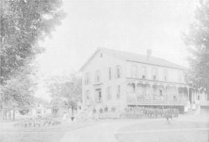
Thomas Orphan Asylum

The pagan element, as a general rule, is opposed to education. Exceptions are sometimes found. Families with small means, unwilling to make any effort to change their condition, claim that they need their children for homework. Even when they enter them at the beginning of the term, they do not enforce their attendance. The children, to a large extent, inherit careless, sluggish, indolent natures, and a lazy spirit. In some respects their capacities are above the average standard of the white people. They are more uniformly good penmen, good musicians, and excel in drawing, but the statements of the Indians … Read more

Industry and Home Life on the Reservations

Farming is the chief employment of the Six Nations Indians, and the products are typical of the varying soils of the different reservations. While more land is under cultivation than heretofore, the barns are mainly old and in had condition. This is largely true of similar buildings upon the adjoining farms of the white people, as farming has not of late netted an amount sufficient for repairs. The Indians, with no cash capital us a rule, have been compelled to lease their lands to the white people for cash rent or work them on shares. The death of influential men … Read more

Religion of the Six Nation Tribes

With the exception of the Tuscaroras, each of the Six Nations has one or more council houses, in which the people assemble for business or purely Indian ceremonies, religious or social. There is also a council house or town hall on the Mount Hope road of the Tuscarora reservation, but the pagan party has no footing among this people. The council houses, formerly built of logs, are practically in disuse, and frame buildings, about 40 by 80 feet, with fireplace or simple chimney at each end, which allows separate sittings for the sexes, have taken their place. A new building … Read more

Wampum Belts

Reading The Wampums

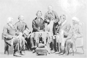
The Iroquois League had its democratic and republican elements, but the separate national governments were essentially oligarchic. The only semblance of written law was the wampum. It was the duty of the “keeper of the wampums” to store all necessary facts in his memory and associate them with the successive lines and arrangements of the beads so that they could readily be called to mind. At general councils the wampums were produced and solemnly expounded. “Reading the wampums” became therefore a means by which to perpetuate treaties, and the exchange of wampums was an impressive occasion. Both the Canadian and … Read more

Tonawanda Reservation Map and Occupants, 1890

The Tonawanda Reservation, in the counties of Erie, Genesee, and Niagara, New York, as originally surveyed in 1799, and as reserved by the treaty at Big Tree, covered 71 square miles. Coincident with a treaty between the United States and this band of Seneca Indians, March 31, 1859, promulgated November 5, 1859, the claim of the Ogden Land Company was extinguished, and the present reservation limits embrace 7,549.73 acres, lying partly in each of the counties of Erie, Genesee, and Niagara. One heavy dirt road, almost impassable in the spring or an ordinarily wet season, runs out from the center … Read more

St. Regis Tribe

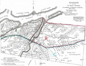
St. Regis Reservation Map, 1890

This article, written in 1890, provides a detailed account of the St. Regis Mohawk people, a group of Indigenous people residing on a reservation that straddles the border of New York and Canada. It examines their history, traditions, and current social, economic, and political realities. The article discusses their unique governance structure, the influence of French culture and Christianity on their way of life, and the challenges posed by their proximity to both the United States and Canada. It also highlights their engagement with the education system and explores the complexities of their identity and naming practices.

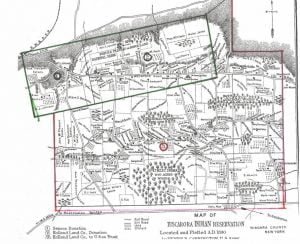
Tuscarora Reservation Map and Occupants, 1890

Tuscarora Reservation Map, 1890

The Tuscarora Reservation, in Niagara County, New York, is formed from 3 adjoining tracts successively acquired, as indicated on the map. Their early antecedents as kinsmen of the Iroquois, their wanderings westward to the Mississippi, and their final lodgment at the head waters of the rivers Neuse and Tar, in North Carolina, are too much enveloped in tradition to be formulated as history, but courageous, self-supporting, and independent, after long residence upon lands owned by them in that colony, they first came into collision with white people, then with other tribes of that section, until finally, overpowered by numbers, they … Read more

Cattaraugus Indian Reservation Map and Occupants, 1890

Theodore F. Jimerson (De-hah-teh), Cattaraugus Seneca

The Cattaraugus Reservation, in Cattaraugus, Chautauqua, and Erie Counties, New York, as delineated on the map, occupies both sides of Cattaraugus creek. It is 9.5 miles long on a direct east and west line, averages 3 miles in width at the center, dropping at is eastern line an additional rectangle of 2 by 3 miles. A 6-mile strip on the north and 2 “mile blocks” at diagonal corners are occupied by white people, and litigation is pending as to their rights and responsibilities. The Seneca Nation claims that the permit or grant under which said lands were occupied and improved … Read more

Cornplanter Reservation and Occupants, 1890

This reservation, in Warren County, Pennsylvania, nominally a tract of 640 acres, owned by Cornplanter‘s heirs, lies on both sides of the Allegheny River, and is about 2 miles long and half a mile wide, including Liberty and Donation Islands, which are formed by the forking of the river. The land surface, including the riverbed and some worthless shoals, contains about 760 acres. It was a donation to the celebrated chief Gy-ant-wa-hia, “The Cornplanter“, March 16, 1796, by the state of Pennsylvania, in consideration, states Judge Sherman, “for his many valuable services to the white people, and especially that most … Read more

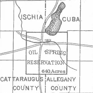
Oil Spring Reservation Map

Oil Spring Reservation Map, 1890

Oil Spring reservation, in Cattaraugus County, New York, as indicated on the Allegany reservation map, contains 640 acres in 2 towns and counties. It was by oversight included in the treaty made at Big Tree, in the sale by the Seneca Nation of 3,500,000 acres to Robert Morris, and passed with his title to the Holland Land Company. A suit for the recovery of this land was brought in 1856, and resulted in favor of the Seneca Nation. On the trial Governor Blacksnake, as he was named by Washington when he visited the capital in company with Cornplanter, testified, at … Read more

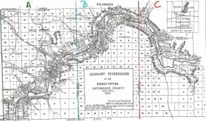
Allegany Reservation Map and Occupants, 1890

Allegany Reservation Map, 1890

Allegany Reservation, lying in Cattaraugus County, New York, has remarkable features in very respect, and of great social and political concern. Besides resting under the burden of the Ogden Land Company pre-emption right to purchase whenever the Seneca Nation shall agree to sell its lands, it is already occupied in part by white people, who, in large numbers, hold duly legalized leases, running until May, 1892, and subject by recent act of Congress to renewal upon the consent of the parties thereto for a term not exceeding 99 years. Upon location of the New York, Lake Erie and Western and … Read more