Tuscarora Reservation Map and Occupants, 1890

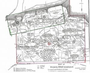
Tuscarora Reservation Map, 1890

The Tuscarora Reservation, in Niagara County, New York, is formed from 3 adjoining tracts successively acquired, as indicated on the map. Their early antecedents as kinsmen of the Iroquois, their wanderings westward to the Mississippi, and their final lodgment at the head waters of the rivers Neuse and Tar, in North Carolina, are too much enveloped in tradition to be formulated as history, but courageous, self-supporting, and independent, after long residence upon lands owned by them in that colony, they first came into collision with white people, then with other tribes of that section, until finally, overpowered by numbers, they … Read more

Cattaraugus Indian Reservation Map and Occupants, 1890

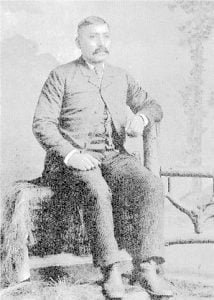
Theodore F. Jimerson (De-hah-teh), Cattaraugus Seneca

The Cattaraugus Reservation, in Cattaraugus, Chautauqua, and Erie Counties, New York, as delineated on the map, occupies both sides of Cattaraugus creek. It is 9.5 miles long on a direct east and west line, averages 3 miles in width at the center, dropping at is eastern line an additional rectangle of 2 by 3 miles. A 6-mile strip on the north and 2 “mile blocks” at diagonal corners are occupied by white people, and litigation is pending as to their rights and responsibilities. The Seneca Nation claims that the permit or grant under which said lands were occupied and improved … Read more

Cornplanter Reservation and Occupants, 1890

This reservation, in Warren County, Pennsylvania, nominally a tract of 640 acres, owned by Cornplanter‘s heirs, lies on both sides of the Allegheny River, and is about 2 miles long and half a mile wide, including Liberty and Donation Islands, which are formed by the forking of the river. The land surface, including the riverbed and some worthless shoals, contains about 760 acres. It was a donation to the celebrated chief Gy-ant-wa-hia, “The Cornplanter“, March 16, 1796, by the state of Pennsylvania, in consideration, states Judge Sherman, “for his many valuable services to the white people, and especially that most … Read more

Oil Spring Reservation Map

Oil Spring Reservation Map, 1890

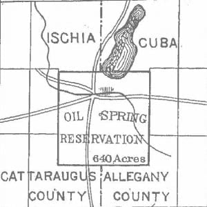
Oil Spring reservation, in Cattaraugus County, New York, as indicated on the Allegany reservation map, contains 640 acres in 2 towns and counties. It was by oversight included in the treaty made at Big Tree, in the sale by the Seneca Nation of 3,500,000 acres to Robert Morris, and passed with his title to the Holland Land Company. A suit for the recovery of this land was brought in 1856, and resulted in favor of the Seneca Nation. On the trial Governor Blacksnake, as he was named by Washington when he visited the capital in company with Cornplanter, testified, at … Read more

Allegany Reservation Map and Occupants, 1890

Allegany Reservation Map, 1890

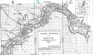
Allegany Reservation, lying in Cattaraugus County, New York, has remarkable features in very respect, and of great social and political concern. Besides resting under the burden of the Ogden Land Company pre-emption right to purchase whenever the Seneca Nation shall agree to sell its lands, it is already occupied in part by white people, who, in large numbers, hold duly legalized leases, running until May, 1892, and subject by recent act of Congress to renewal upon the consent of the parties thereto for a term not exceeding 99 years. Upon location of the New York, Lake Erie and Western and … Read more

List of Occupants of the Onondaga Reservation, Onondaga County, New York

Onondaga Reservation Map, 1890

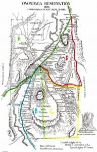
The Onondaga reservation, lying in Onondaga County, forms a rectangle of a little more than 2.3 miles by 4 miles, commencing about 5 miles southward from the city of Syracuse, and contains about 6,100 acres: Onondaga castle, with hotel, store, post office, and a few houses, is at the “entrance gate “. The blue limestone quarries belonging to the Onondaga Nation furnish excellent building material, but the deep strata, which will measure from 18 to 20 inches in thickness, are 20 feet below the ground surface, requiting laborious and expensive stripping. Only 3 derricks are now worked, each paying to … Read more

Reservations of the Six Nations in New York and Pennsylvania, 1723-1890

Map of the Country of the Five Nations

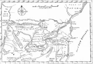
The accompanying map was prepared in 1771 under the direction of William Tryon, captain general and governor in chief of the province of New York, and is as nearly suggestive of the then recognized boundary of the Six Nations as any that has had official sanction. In 1851 Lewis H. Morgan, assisted by Ely S. Parker, a Seneca chief; and afterward an efficient staff Officer of General Grant, and the Commissioner of Indian Affairs, prepared a map for a volume entitled League of the Iroquois, which aimed to define the villages, trails, and boundaries of the Five Nations as they … Read more

Historical Outline of The Six Nations

Solomon George, Oneida

By Henry B. Carrington The retirement of the Indian westward within the United States has been qualified by two historical factors. The first grew out of the unlimited and conflicting sweep of British land grants, which involved subsequent conflicts of jurisdiction and corresponding compromises. The second was incidental’ to the passage of the ordinance of July 13, 1787, which organized the Northwest Territory. The first, especially in the adjustment of the claims of Massachusetts and New York to the same lands, dealt with Indian titles and rights, which neither party could wholly ignore. The white men had overlapped and practically … Read more

The St. Regis, Successors of the Mohawks

St. Regis River, St. Regis parish, at the junction of the river with the St. Lawrence River, St. Regis Island, directly opposite, and St. Regis reservation, in New York, alike perpetuate the memory of Jean. Francois Regis, a French ecclesiastic of good family, who consecrated his life from early youth to the welfare of the laboring classes. He sought an appointment as missionary to the Iroquois Indians of Canada, but was unable to leave home, and died in 1640. The French Jesuits as early as 1675 established a mission among the Caughnawaga, 9 miles above Montreal, and gathered many of … Read more

The Six Nations of New York

livestock

The uncertainty and doubt surrounding most North American Indian history are partially removed from the Six Nations. They, of all American Indians, have best preserved their traditions. Besides, their system was so complete, and their government so unique and so well fitted to the people, that from the earliest European arrival they have been constantly written about. Their small numbers, compared with the enormous country they occupied and the government they originated with their deeds of daring, will always excite surprise. Their league, tribal and individual characteristics and personal strength of will, together with their great courage and prowess, account … Read more

Condition of New York Indians in the 1890 Census

Chief Cornplanter

This collection of material provides an extensive look into the New York Indian tribes as they existed in 1890. While some attention is given to the remnants of the Long Island Indians, most of the material is specific to the Six Nations. The data includes maps of the Reservations, and lists and photographs of occupants of those reservations in 1890.

1890 Report on the Pueblos of Laguna, Acoma and Zuñi

By Julian Scott, Special Agent The following report was prepared during September and October 1890, and August and September 1891: Laguna Pueblo Acoma Pueblo Zuñi Pueblo My observation in the 3 pueblos of Laguna, Acoma, and Zuñi is, that the so called control of these people by the United States government makes them expectant, and they hurry to Santa Fe to the United States Indian agent on small matters, Their civilization from an Anglo Saxon standpoint is nominal, still they are more provident than their New Mexican neighbors. These people should at once be dropped by the nation and required … Read more

Zuñi Pueblo

Home of WeWa, Pueblo of Zuni, 1890

Zuñi lies in a great plain, or valley, through which the Zuñi River flows. On account of the severe storm that had prevailed for a number of days the streets of the town were in a horrible condition, and looked as if they were never cleaned. They are now higher than the ground floors of the houses, though they were evidently once on the same level. Some of the terraced buildings are 5 stories high, reached by clumsy ladders and narrow partition steps of adobe or stone. All those visited were very clean inside, but as a general rule cheerless … Read more

Acoma Pueblo

The Rock and Pueblo of Acoma, New Mexico

Reaching the open plain, we came within view of the rock of Acoma, and were in a little while watering our horses at the reservoir over which the pueblos are quarreling. The water was very low and there wore evidences of recent neglect. The rock of Acoma, bears the pueblo of that name. It seems unreasonable that such a site should have been selected by its founders for a habitation except for protection against the more warlike tribes that infested the great plains, roaming at will, preying upon their fields, and later their herds. The distance to wood and water, … Read more

Laguna Pueblo

Mesa Encantado

The night of October 17, 1890, found me a lodger in the railroad station at Laguna. The day after my arrival I went to the pueblo, which is but a few minutes walk west of the station, and was introduced to the Principal men of Laguna, who, learning the nature of my visit, received me with every expression of respect. The town is built upon a sandstone ledge, the southern base of which is washed by the San Jose. The streets are narrow and winding, and in some places very steep, requiring stone steps. The houses are constructed of stone … Read more

The Tablita or Corn Dance

Male Pueblo Dancer

The question of physical condition is one less dependent upon diet than the mode of life which renders general development a result, No better test of a high grade of physique could be found than the prolonged and fatiguing dances, lasting for the greater part of as day, indulged in at all of the pueblos. I have witnessed three of these great dances and several minor ones. At San Domingo, August 12, 1890, 200 dancers, male and female, participated, led by 2 choruses, each of 40 male voices. This display being regarded the finest to be seen among pueblos, with … Read more

Observations of the Census of the Pueblo Indians, 1890

For various reasons statistics compiled from schedules of enumerators as applied to the area under cultivation would be misleading. Upon the ordinary blanks used for agricultural statistics the instructions were that no entry was to be made of farms under 3 acres. Very many farms among these villages do not contain that amount, awl were therefore not included. Again, in a number of cases enumerators were not faithful either in inquiries or entries. On the schedules of Jemez, Cochiti, and San Domingo the number of farms and not their area was given. The, enumerators of San Felipe, Sandia, Santa Ana, … Read more

Picuris Pueblo

The following report was furnished by Mr. Frederick P. Midler, of Taos, New Mexico, February 20, 1891 I have just returned from the pueblo of Picuris. On the journey I and my horse came near freezing, The snow on the mountains and on the trail is 4.5 feet deep. No human being has passed through there this winter, The Indian land under cultivation at Picuris amounts to 555 acres. Out of this every family owns an average of about 15 acres. The sanitary condition can not be called good, as the statistics of the pueblo show that they are every … Read more

Isleta Pueblo

Pueblo of Isleta

On arriving in Isleta one immediately marks numerous points of difference between this community and the more northern pueblos in matters of dress, building, and customs. The town is composed entirely of 1 story dwellings, for the most part detached, though not isolated from neighboring habitations. These are always commodious and built frequently after the Spanish custom, about a court, or plaza.. Tables are generally found within, though not always dined upon, and chairs of Americain manufacture are usually to be had to offer a stranger; but the ease of a roll of blankets on the floor is not forgotten … Read more

Sandia Pueblo

Like San Felipe, the Sandia Pueblo community holds more land than it can improve. The large Mexican town of Bernalillo presses upon the north side of its tract of 24,187 acres, In 1824 the Indians of the pueblo gave the land on which the town stands, but no patent of this transaction is inexistence. Sales are consummated in the town and await confirmation, Passing 1,200 acres of open land, here and there developing weak traces of alkali, left as a pasture open to the use of the town, cultivation begins half a mile from the pueblo. The acequia, at a … Read more